This hike has it all: two gorgeous lakes, a short walk
along the Continental Divide, and memorable views of several 14,000-foot
Collegiate Peaks. At 12.9 miles it is a relatively easy backpack trip with a
choice of two lakes as campsites. If you get an early start you will
probably want to spend the night at Kroenke Lake, 8.2 miles from the Denny
Creek Trailhead. If you get a late start, however, you can also camp at
Hartenstein Lake which is only 3.0 miles from the trailhead. Either lake is
a beautiful place to spend the night. The hike described here begins at the
Denny Creek Trailhead, but you can just as easily do the trip in the
opposite direction.
Day 1 ( 8.9 miles):
The trail follows the west side of Denny Creek for the
first 1.0 mile, then crosses the creek on a primitive log bridge as it
continues to climb toward the Continental Divide. 0.3 mile beyond Denny
Creek you will come to a well-marked trail junction where the trail to Mount
Yale departs on the right. Up to that point the trail is so wide it
sometimes looks more like a jeep road than a foot path, but beyond the
junction the trail soon narrows down. Also, as you gain elevation the forest
seems to thin a bit, yielding occasional views of the mountains north and
west of the trail.
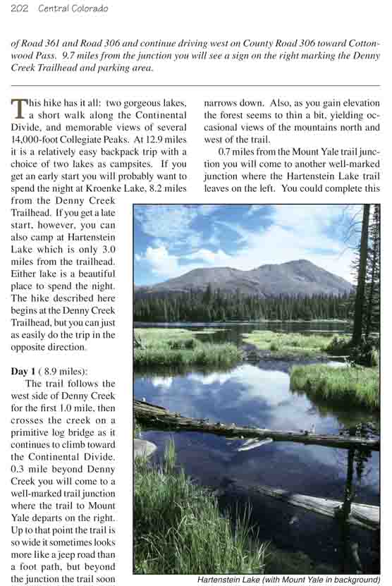
0.7 miles from the Mount Yale trail junction you will
come to another well-marked junction where the Hartenstein Lake trail leaves
on the left. You could complete this hike without taking the detour to
Hartenstein, but it is such a pretty lake it would be a shame to miss it. It
is just a half-hour’s walk from the main trail over an easy path with an
elevation gain of only 330 feet. As you approach Hartenstein you will notice
a treeless slope above the north side of the lake that is swept clean almost
every winter by avalanches. The slope descends 1,200 feet from the ridge
above at an almost constant 30-degree angle-a perfect avalanche chute. Not a
place you would want to be in late winter or early spring! There are some
excellent campsites where the trail ends at Hartenstein Lake, and if it is
late in the day you may want to consider spending the night there instead of
pushing on to Kroenke Lake.
The Kroenke Lake Trail crosses the North Fork of Denny
Creek just a few yards beyond its junction with the Hartenstein Lake Trail,
and from there it climbs another 900 feet over a distance of 1.6 miles to
the summit of Browns Pass. This part of the hike is very pleasant. The trail
is situated in an alpine bowl just east of the Continental Divide, and as
you pass above timberline you will have an unimpeded view of Mount Yale
further to the east. Finally, when you reach Browns Pass the full glory of
the Collegiate Peaks Wilderness Area opens up before you. Texas Creek runs
through the deep canyon directly below the pass, and above the north side of
the canyon a long like of dramatic mountain peaks marches east to west
across the skyline. First in line is Mt. Columbia, followed by Mt. Harvard.
Then there is Emerald Peak, a near fourteener, with Missouri Mountain, Mt.
Belford and Mt. Oxford behind it. And finally, further to the west, the
distinctive Three Apostles.
300 feet below the north side of Browns Pass you can see
the remains of an old broken-down cabin, Browns Cabin, that was once well
known to hikers in the area. Before the 1990s the hundred-year-old cabin was
still intact and backpackers frequently used it as an overnight stop. The
cabin had a large attic and an iron stove, and there was plenty of room to
roll out sleeping bags on the floor. Unfortunately, sometime in the
late-1990s the winter snow-load proved to be too much for the old shelter
and the roof collapsed. Now Browns Cabin is little more than a gigantic pile
of logs, but it is still fun to visit and poke around in the debris. A
detour to the cabin and back will add 0.7 mile to the length of this hike.
From Browns Pass the trail climbs up the ridge that
defines the Continental Divide, then zigzags along the north side of the
Divide for 1.4 miles to a saddle at the head of North Cottonwood Creek. This
is all alpine tundra country, well above timberline, and walking across it
on a carpet of grass and wildflowers with the spectacular Collegiate Peaks
rising dramatically above Texas Creek on your left and Mount Yale on your
right is an exhilarating experience. The trail between Browns Pass and
Kroenke Lake is easily my favorite part of this hike.
Upon reaching the basin above North Cottonwood Creek the
trail makes a long descending turn around the north side of the bowl (in
order to avoid a snowfield), and then heads east down the drainage towards
Kroenke Lake. Finally, 0.8 mile after leaving the Divide, the path arrives
at a terrific overlook point above the lake and then makes its way down the
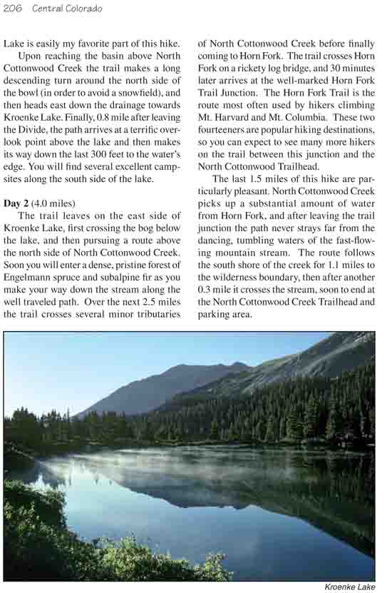
last 300 feet to the water’s edge. You will find several excellent campsites
along the south side of the lake.
Day 2 (4.0 miles)
The trail leaves on the east side of Kroenke Lake, first
crossing the bog below the lake, and then pursuing a route above the north
side of North Cottonwood Creek. Soon you will enter a dense, pristine forest
of Engelmann spruce and subalpine fir as you make your way down the stream
along the well traveled path. Over the next 2.5 miles the trail crosses
several minor tributaries of North Cottonwood Creek before finally coming to
Horn Fork. The trail crosses Horn Fork on a rickety log bridge, and 30
minutes later arrives at the well-marked Horn Fork Trail Junction. The Horn
Fork Trail is the route most often used by hikers climbing Mt. Harvard and
Mt. Columbia. These two fourteeners are popular hiking destinations, so you
can expect to see many more hikers on the trail between this junction and
the North Cottonwood Trailhead.
The last 1.5 miles of this hike are particularly
pleasant. North Cottonwood Creek picks up a substantial amount of water from
Horn Fork, and after leaving the trail junction the path never strays far
from the dancing, tumbling waters of the fast-flowing mountain stream. The
route follows the south shore of the creek for 1.1 miles to the wilderness
boundary, then after another 0.3 mile it crosses the stream, soon to end at
the North Cottonwood Creek Trailhead and parking area.