The highlights of this hike are two gorgeous waterfalls
that are located 3.0 miles from the trailhead. The falls are an easy walk
from the road with an elevation gain of only 750 feet, and upon reaching
them most people go no further. There are several more waterfalls along
Fourmile Creek, however, and the additional 2.3-mile walk to the head of the
fast-flowing mountain stream will yield additional rewards. The trail
finally ends at Fourmile Lake, a 600-foot diameter tarn hidden in the back
of a basin on the northeast side of Pagosa Peak.
If you want to experience Fourmile Creek at its very best
try to begin this hike no more than a half-hour after sunrise. The trail
passes through a succession of pristine mountain meadows along the stream
that are a delight to experience in the early morning hours. The show begins
at dawn, when clouds of mist begin rising from the due-covered grass that
surrounds the creek. The soft light flickering through the mist onto the
wildflowers and the clean, white trunks of the bordering quaking aspen make
an enchanting prolog to the day. Birds of all kinds flock to the meadows at
daybreak, and their songs combine with the sounds of the running water to
fill the parks with nature’s music. Morning is also the best time to see
Fourmile Falls. The highest of the two falls faces directly east, and for a
few precious hours each day its watery descent is bathed in the glory of the
morning sunshine.
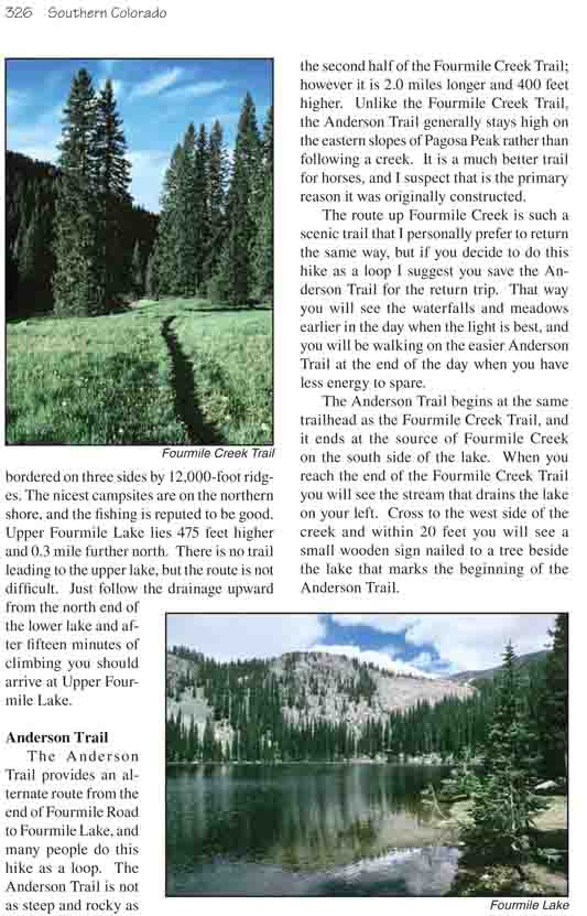
From the trailhead the hike begins by winding gently
downward through a primeval forest of Engelmann spruce. After an
elevation loss of 200 feet over a distance of 0.7 mile the trail crosses
the southern boundary of the Weminuche Wilderness Area, and soon
afterward it enters the first of several long, narrow meadows that line
the banks of the creek. The route crosses several small streams that
flow into Fourmile Creek from the west, but they are easily crossed on
rocks and fallen logs.
After 2.6 miles you will begin to catch glimpses of
one of the falls on the north side of the valley, then it disappears
behind the trees and reemerges again only when you are almost directly
below it. The first fall you will see pours off a 300-foot cliff of
volcanic breccia. It is fed by Falls Creek, a small side stream that
flows into Fourmile Creek from the west. The fall is some 250 feet high,
with a sheer vertical drop of two-thirds that distance. The setting is
magnificent, but if you are taking pictures you had better have a
wide-angle lens for your camera.
After crossing Falls Creek below the waterfall the
trail becomes rocky and steep as it climbs along the west side of Fourmile Creek.
Then, only 250 yards from the first fall you will pass near the top of
another equally impressive waterfall. The second fall is fed by Fourmile
Creek itself, and the volume of water is at least 3-4 times greater. This
fall roars over a break in the streambed and shoots down 120 feet to a
calamitous end on the boulders below. Unfortunately, because of the heavy
vegetation it is impossible to get a good view of the second fall from the
trail. There is a large, open area at the bottom of the fall with an
unimpeded view, but getting there requires some serious bushwhacking.
As if two were not enough, there is a third waterfall on
Fourmile Creek just 0.1 mile above the second fall. The third one does not
have a long vertical drop like the first two, but it is still worth pausing
to look at. The gradient of the creek (and the trail!) is so steep after the
first 3.0 miles that waterfalls are inevitable, and as you proceed upward
you will be treated to one cascade after another. If you are doing this hike
in early summer before the spring runoff has ended the rushing water is
particularly dramatic.
Five minutes beyond the third waterfall the trail crosses
to the east side of the creek. Older maps indicate that there was once a
steel bridge across the creek at this point, but now there is scarcely a
trace of the old span. It has been gone for at least 20 years, but
fortunately there is a fallen log nearby so it is possible to cross the
water without getting your feet wet.
The trail stays on the east side of the water for only
about 10 minutes before crossing back again. When you are back on the west
side pause to look 200 yards upstream and you will see yet another dramatic
cascade of whitewater roaring down another chute in the streambed. This is
also a fine area for camping if you are carrying a tent. The forest is open
and flat for some distance below the cascade, and one couldn’t ask for a
more inspirational place to spend a night.
Soon the trail crosses to the east side of the creek for
the second time, where it will remain for the rest of the way to the lake.
After 15 minutes you will see a sign at a trail junction where the trail to
Turkey Creek Lake branches off to the right. Bear left here and soon you
will enter the southern end of another long alpine meadow that lines the
shores of Fourmile Creek. The trail stays in the meadow for 0.7 mile before
climbing into the trees on its northern side. Finally it climbs the last 200
feet to end at the southern shore of Fourmile Lake.
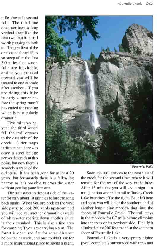
Fourmile Lake is a very pretty alpine jewel,
completely surrounded with trees and bordered on three sides by
12,000-foot ridges. The nicest campsites are on the northern shore, and
the fishing is reputed to be good. Upper Fourmile Lake lies 475 feet
higher and 0.3 mile further north. There is no trail leading to the
upper lake, but the route is not difficult. Just follow the drainage
upward from the north end of the lower lake and after fifteen minutes of
climbing you should arrive at Upper Fourmile Lake.
Anderson Trail
The Anderson Trail provides an alternate route from the
end of Fourmile Road to Fourmile Lake, and many people do this hike as a
loop. The Anderson Trail is not as steep and rocky as the second half of the
Fourmile Creek Trail; however it is 2.0 miles longer and 400 feet higher.
Unlike the Fourmile Creek Trail, the Anderson Trail generally stays high on
the eastern slopes of Pagosa Peak rather than following a creek. It is a
much better trail for horses, and I suspect that is the primary reason it
was originally constructed.
The route up Fourmile Creek is such a scenic trail that I
personally prefer to return the same way, but if you decide to do this hike
as a loop I suggest you save the Anderson Trail for the return trip. That
way you will see the waterfalls and meadows earlier in the day when the
light is best, and you will be walking on the easier Anderson Trail at the
end of the day when you have less energy to spare.
The Anderson Trail begins at the same trailhead as the Fourmile Creek
Trail, and it ends at the source of Fourmile Creek on the south side of the
lake. When you reach the end of the Fourmile Creek Trail you will see the
stream that drains the lake on your left. Cross to the west side of the
creek and within 20 feet you will see a small wooden sign nailed to a tree
beside the lake that marks the beginning of the Anderson Trail.