Y Mountain Trail
excerpted from our book
Salt Lake City's Incredible Hiking and Biking Trails
pages 216-220
|
Buy book directly from the author!
Salt Lake City's Incredible Hiking and Biking Trails
- has access info for 73 trailheads
- 73 colorful trail maps
- 325 full color photographs
- loads of hiking tips
|
regularly $19.95
now on sale for only
$9.95
click here
for book orders
|
 Perhaps the most iconic symbol of Provo’s Brigham Young University is the enormous whitewashed Y on the side of Y Mountain east
of the campus. It has long been a tradition among American schools and universities to paint symbolic letters on hillsides near their campuses, but at 380
feet long and 130 feet wide, the BYU’s Y is probably the largest such collegiate symbol in the United States. It is also one of the oldest; the Y has
looked down on the city of Provo since the spring of 1906, when several hundred students from the recently established Brigham Young University and
Brigham Young High School hiked up the mountain with bags of lime and sand to paint the huge Y.
Perhaps the most iconic symbol of Provo’s Brigham Young University is the enormous whitewashed Y on the side of Y Mountain east
of the campus. It has long been a tradition among American schools and universities to paint symbolic letters on hillsides near their campuses, but at 380
feet long and 130 feet wide, the BYU’s Y is probably the largest such collegiate symbol in the United States. It is also one of the oldest; the Y has
looked down on the city of Provo since the spring of 1906, when several hundred students from the recently established Brigham Young University and
Brigham Young High School hiked up the mountain with bags of lime and sand to paint the huge Y.
The original plan was to construct three letters, B-Y-U, on the mountain, and in order to make sure the other letters were properly aligned the middle Y
was done first. The work proved to be so exhausting that plans to construct the B and the U were ultimately abandoned, but the completion and
preservation of the Y has never been in doubt. Every year thousands of students converge on the
Y Mountain Trail to repair and repaint it. The letter
has since been modified into a block Y, reinforced with many tons of cement and sand, and even equipped with an electrical generator so it can be
lighted on homecoming night, graduation night, and other special occasions. In 2013 the Brigham Young University succeeded in purchasing 80 acres
of land surrounding the Y from the US Forest Service, thus insuring that the icon will be there as long as the university exists.
The Y Mountain Trail described here climbs 1.1 miles to the top of the Y and then continues another 2.1 miles to the top of the mountain above the Y. Although
thousands of people make the journey to the Y every year, only a small percentage of them bother to climb on to the summit of Y Mountain. This is
a shame because the second half of the hike is very scenic, and being so close to Provo makes it even more special. Unfortunately, the Y cannot be
easily seen from the top of the mountain, but the view of the BYU campus and the city beyond is superb.
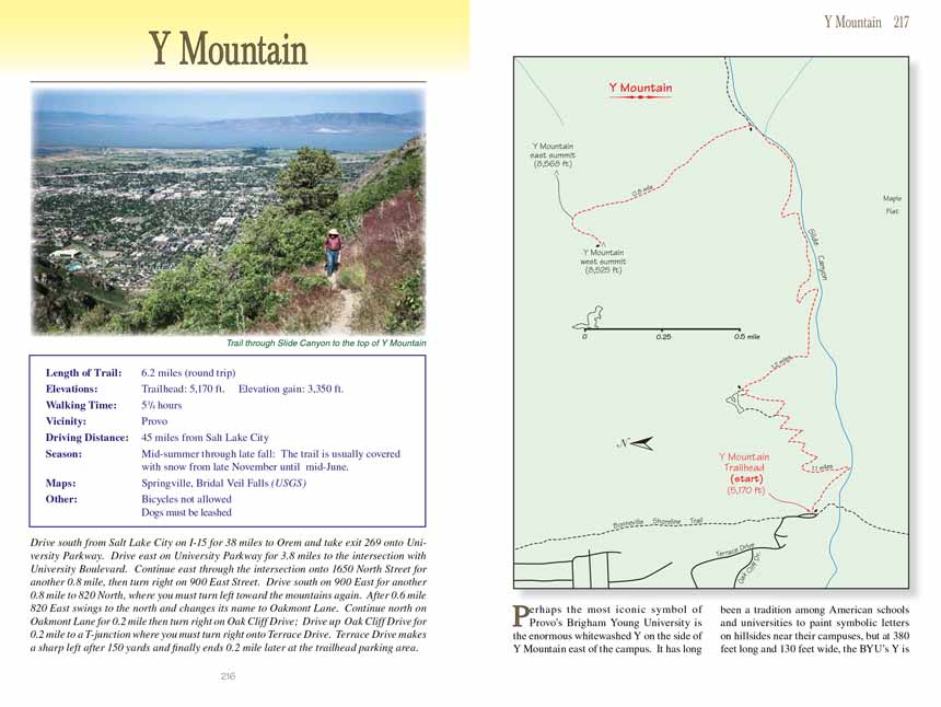
From the parking area the Y Mountain Trail starts climbing immediately along a steady grade that never changes much over the next 1.1 miles to the top of the Y.
Before reaching the Y you will have gained 1,100 feet but the Y Mountain Trail is wide and relatively smooth, and there are benches where you can rest at the
beginning of nearly every switchback. Best of all, if you start before about 8:30 you will be in shade the entire distance. The summer sun doesn’t
reach the west face of Y Mountain until well past 9:00 a.m.
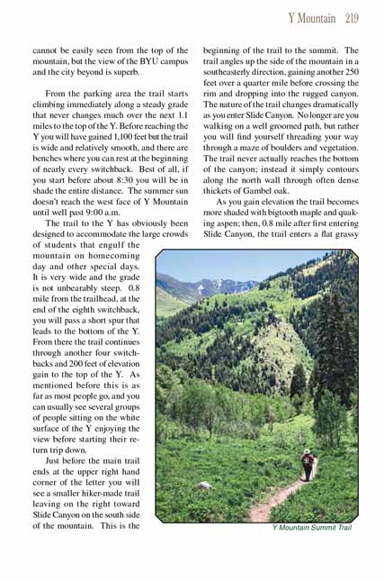
The Y Mountain Trail as far as the Y has obviously been designed to accommodate the large crowds of students that engulf the mountain on homecoming day and other special
days. It is very wide and the grade is not unbearably steep. 0.8 mile from the trailhead, at the end of the eighth switchback, you will pass a short
spur that leads to the bottom of the Y. From there the Y Mountain Trail continues through another four switchbacks and 200 feet of elevation gain to the top of
the Y. As mentioned before this is as far as most people go, and you can usually see several groups of people sitting on the white surface of the Y
enjoying the view before starting their return trip down.
 Just before the main trail ends at the upper right hand corner of the letter you will see a smaller hiker-made trail leaving
on the right toward Slide Canyon on the south side of the mountain. This is the beginning of the
Y Mountain Trail to the mountain's summit. The trail angles up the side of the
mountain in a southeasterly direction, gaining another 250 feet over a quarter mile before crossing the rim and dropping into the rugged canyon. The
nature of the Y Mountain Trail changes dramatically as you enter Slide Canyon. No longer are you walking on a well groomed path, but rather you will find yourself
threading your way through a maze of boulders and vegetation. The trail never actually reaches the bottom of the canyon; instead it simply contours
along the north wall through often dense thickets of Gambel oak.
Just before the main trail ends at the upper right hand corner of the letter you will see a smaller hiker-made trail leaving
on the right toward Slide Canyon on the south side of the mountain. This is the beginning of the
Y Mountain Trail to the mountain's summit. The trail angles up the side of the
mountain in a southeasterly direction, gaining another 250 feet over a quarter mile before crossing the rim and dropping into the rugged canyon. The
nature of the Y Mountain Trail changes dramatically as you enter Slide Canyon. No longer are you walking on a well groomed path, but rather you will find yourself
threading your way through a maze of boulders and vegetation. The trail never actually reaches the bottom of the canyon; instead it simply contours
along the north wall through often dense thickets of Gambel oak.
As you gain elevation the Y Mountain Trail becomes more shaded with bigtooth maple and quaking aspen; then, 0.8 mile after first entering Slide Canyon, the trail
enters a flat grassy meadow. This meadow, called Bear Flat, marks the end of Slide Canyon, and from that point on the terrain is much gentler. Upon
leaving Bear Flat you will be walking through an aspen forest, and after a few hundred yards you will come to a fork in the trail where you must turn
left. There are no signs at the fork, but if you are observant you will see a large Y carved into the trunk of one of the quaking aspens. This junction
marks the beginning of the Y Mountain summit trail to the top of Y Mountain.
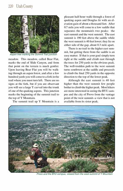
The summit trail up Y Mountain is a pleasant half-hour walk through a forest of quaking aspen and Douglas fir with an elevation gain of about a thousand
feet. After 0.7 mile you will come to a low saddle that separates the mountain's two peaks: the east summit and the west summit. The east summit is 190
feet above the saddle while the west summit is 40 feet lower; they lie on either side of the gap, about 0.3 mile apart.
There is no trail to the higher east summit, but getting there from the saddle is an easy matter. If that is your goal simply turn right at the saddle
and climb east through the trees for 250 yards to the obvious peak. The well-trodden
Y Mountain Trail to the west summit turns southwest at the saddle and proceeds
to climb the final 250 yards in the opposite direction to the top of the lower peak.
Although the east summit is 40 feet higher than the west summit few people bother to climb the higher peak. Most hikers are more interested in seeing the
BYU campus and the city of Provo from the vantage point of the west summit-a view that is not available from its sister peak.
Note to web developers: You may copy this material onto your site, but in return please include a link to my home page
www.utahtrails.com. Thank you, David Day (utahdavidday at gmail.com)
Click here to see more
trails near Salt Lake City
© Rincon Publishing Company, all rights reserved
|