Stewart Falls Trail
excerpted from our book
Salt Lake City's Incredible Hiking and Biking Trails
pages 196-198
|
Buy book directly from the author!
Salt Lake City's Incredible Hiking and Biking Trails
- has access info for 73 trailheads
- 73 colorful trail maps
- 325 full color photographs
- loads of hiking tips
|
regularly $19.95
now on sale for only
$9.95
click here
for book orders
|
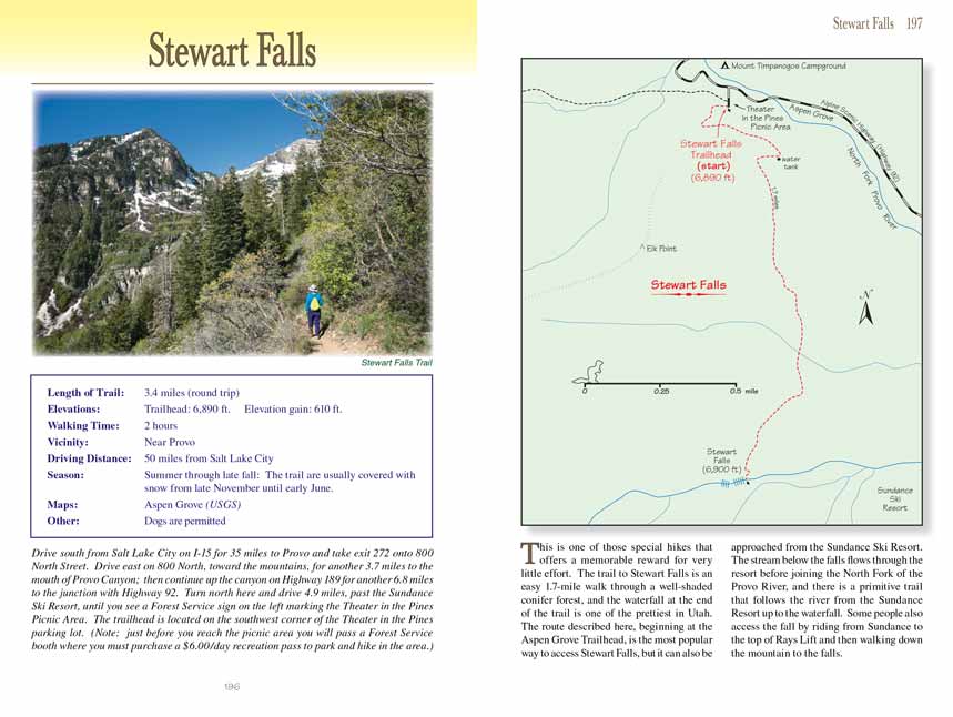
This is one of those special hikes that offers a memorable reward for very little effort. The Stewart Falls
Trail is an
easy 1.7-mile walk through a well-shaded conifer forest, and the waterfall at the end of the trail is one of the prettiest in Utah. The route described
here, beginning at the Aspen Grove Trailhead, is the most popular way to access Stewart Falls, but it can also be approached from the Sundance Ski Resort.
The stream below the falls flows through the resort before joining the North Fork of the Provo River, and there is a primitive trail that follows the
river from the Sundance Resort up to the waterfall. Some people also access the fall by riding from Sundance to the top of Rays Lift and then walking
down the mountain to the falls.
There are two separate trails departing from the Aspen Grove parking area: the trail to Mount Timpanogos, and the Stewart Falls
Trail. The Stewart Falls
Trail is not as well marked as the Timpanogos Trail, so be sure you start of the correct trail. The trail you want is the one that begins on the southwest
side of the parking lot next to the public restrooms. The Stewart Falls Trail first goes west for 150 feet, and then it turns and begins traversing the base of the
mountain in a south and southeasterly direction. This area is heavily forested with large Engelmann spruce and Douglas fir, but occasionally you might
catch glimpses of some buildings below the north side of the trail. These buildings are part of the Aspen Grove Conference Center, a facility owned and
operated by Brigham Young University.
After 0.4 mile you will pass the conference center’s water tank, and from there the
Stewart Falls Trail turns south for the remainder of the hike. The path continues to
climb at a very gradual rate for the next 0.6 mile before reaching its highest point at 7,200 feet, and then it begins an equally gradual descent for the
next 0.6 mile to the base of the waterfall.
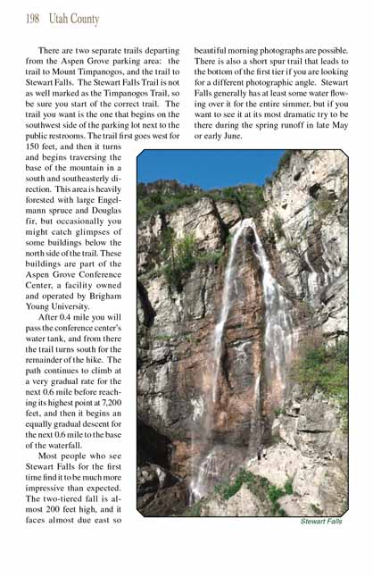
Most people who see Stewart Falls for the first time find it to be much more impressive than expected. The two-tiered fall is almost 200 feet high, and it
faces almost due east so beautiful morning photographs are possible. There is also a short spur trail that leads to the bottom of the first tier if you
are looking for a different photographic angle. Stewart Falls generally has at least some water flowing over it for the entire simmer, but if you want
to see it at its most dramatic try to be there during the spring runoff in late May or early June.
Note to web developers: You may copy this material onto your site, but in return please include a link to my home page
www.utahtrails.com. Thank you, David Day (utahdavidday at gmail.com)
Click here to see more
trails near Salt Lake City
© Rincon Publishing Company, all rights reserved
|