Squaw Peak Trail
excerpted from our book
Salt Lake City's Incredible Hiking and Biking Trails
pages 211-215
|
Buy book directly from the author!
Salt Lake City's Incredible Hiking and Biking Trails
- has access info for 73 trailheads
- 73 colorful trail maps
- 325 full color photographs
- loads of hiking tips
|
regularly $19.95
now on sale for only
$9.95
click here
for book orders
|
 It would be difficult to find a student at Brigham Young University who can’t identify Squaw Peak. The iconic mountain is scarcely
two miles away and rises 3,000 feet above the campus. The summit is only 7,876 feet above sea level, much lower than other nearby summits, but its prominent profile
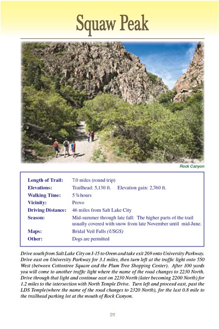
and easy accessibility make it one of Provo’s most popular hiking destinations. Rock Canyon, through which the first half of the Squaw Peak Trail goes, is also an
extremely popular venue for walkers, joggers, and especially rock climbers. Every afternoon dozens of students can be seen practicing their climbing skills beside
the trail on the canyon’s quartzite cliffs.
It would be difficult to find a student at Brigham Young University who can’t identify Squaw Peak. The iconic mountain is scarcely
two miles away and rises 3,000 feet above the campus. The summit is only 7,876 feet above sea level, much lower than other nearby summits, but its prominent profile
and easy accessibility make it one of Provo’s most popular hiking destinations. Rock Canyon, through which the first half of the Squaw Peak Trail goes, is also an
extremely popular venue for walkers, joggers, and especially rock climbers. Every afternoon dozens of students can be seen practicing their climbing skills beside
the trail on the canyon’s quartzite cliffs.
The Rock Canyon Trailhead is now owned by the City of Provo and it appears that the future of the trail through Rock Canyon to Squaw Peak is secure. However it is
worth noting that this has not always been the case. Developers have long coveted Rock Canyon for a variety of reasons, and we are very fortunate that this scenic
treasure still remains unspoiled. As long ago as the 1930s there were attempts to build a ski resort in the Rock Canyon watershed, but each attempt failed because
of inadequate financing. The most recent attempt was made in the late 1980s by the owners of the Seven Peaks Resort in Provo. Their plan was to build a skiing
village above Provo in Maple Flats, and the complex would have included a service road through Rock Canyon. Fortunately for the canyon’s aficionados the plan
was dropped after Seven Peaks’ bankruptcy in 1994.
Public access to Rock Canyon was almost eliminated in the early 1990s when the Provo Planning Commission approved an application for the construction of 13
condominiums on the privately owned land that included the trailhead. Fortunately, a group of activists learned of the plan and succeeded in lobbying the Provo
City Council to purchase the land before it could be developed.
The last threat to Rock Canyon came from a local businessman named Richard Davis. In 1998 Mr. Davis and a partner purchased an old 80-acre mining claim, reportedly
for less than $100,000, on the forest service land at the mouth of Rock Canyon. Five years later, to the horror of local residents, Mr. Davis began mining the
reddish quartzite stone on his claim to sell for landscaping purposes. Fortunately, a series of legal disputes with Red Slab, LLC, an environmental group that
purchased his partner’s interest in the claim, prevented Davis from fully implementing his plan to establish a quartzite quarry. Mr. Davis unexpectedly died
in 2012, and the matter was finally resolved two years later when the Provo City Council reached an agreement with the Davis family to purchase the 80-acre
mining claim for a total of 1.6 million dollars.
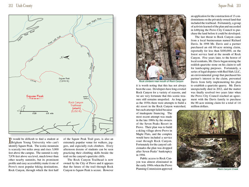
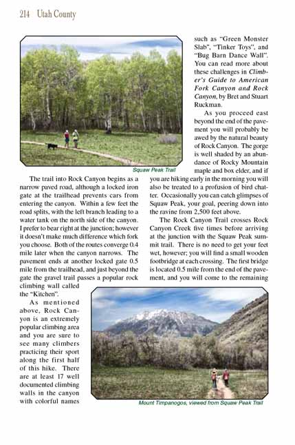
 The trail into Rock Canyon begins as a narrow paved road, although a locked iron gate at the trailhead prevents cars from entering the
canyon. Within a few feet the road splits, with the left branch leading to a water tank on the north side of the canyon. I prefer to bear right at the junction;
however it doesn’t make much difference which fork you choose. Both of the routes converge 0.4 mile later when the canyon narrows. The pavement ends at another
locked gate 0.5 mile from the trailhead, and just beyond the gate the gravel trail passes a popular rock climbing wall called the “Kitchen”.
The trail into Rock Canyon begins as a narrow paved road, although a locked iron gate at the trailhead prevents cars from entering the
canyon. Within a few feet the road splits, with the left branch leading to a water tank on the north side of the canyon. I prefer to bear right at the junction;
however it doesn’t make much difference which fork you choose. Both of the routes converge 0.4 mile later when the canyon narrows. The pavement ends at another
locked gate 0.5 mile from the trailhead, and just beyond the gate the gravel trail passes a popular rock climbing wall called the “Kitchen”.
As mentioned above, Rock Canyon is an extremely popular climbing area and you are sure to see many climbers practicing their sport along the first half of this hike.
There are at least 17 well documented climbing walls in the canyon with colorful names such as “Green Monster Slab”, “Tinker Toys”, and “Bug Barn Dance Wall”. You
can read more about these challenges in Climber’s Guide to American Fork Canyon and Rock Canyon, by Bret and Stuart Ruckman.
As you proceed east beyond the end of the pavement you will probably be awed by the natural beauty of Rock Canyon. The gorge is well shaded by an abundance of
Rocky Mountain maple and box elder, and if you are hiking early in the morning you will also be treated to a profusion of bird chatter. Occasionally you can catch
glimpses of Squaw Peak, your goal, peering down into the ravine from 2,500 feet above.
The Rock Canyon Trail crosses Rock Canyon Creek five times before arriving at the junction with the Squaw Peak trail. There is no need to get your feet wet,
however; you will find a small wooden footbridge at each crossing. The first bridge is located 0.5 mile from the end of the pavement, and you will come to the
remaining four bridges within the next 0.4 mile. Look for another faint trail on the left when you arrive at the fourth bridge. This secondary trail continues
along the north side of the streambed for 200 feet to the opening of an old mine shaft. If you want to explore the mine you better bring a flashlight. It isn’t
very deep but there is a pit in its dark recesses that you wouldn’t want to stumble into.
The Squaw Peak trail junction is located 0.2 mile past the last bridge. It is well marked with a Forest Service “flap-pole” sign and also a large boulder with
the words “Squaw Peak Trail” written on it. The Rock Canyon Trail continues along the bottom of the canyon for another mile to Squaw Peak Road and the Rock Canyon
Campground, but if the summit of Squaw Peak is your destination you must turn left at the
Squaw Peak trail junction. It is another 1.9 miles from the bottom of Rock Canyon to Squaw
Peak.
The climb out of Rock Canyon is the most strenuous part of this hike. You still have another 1,760 feet of elevation gain to deal with, and the trail is not as
well developed as the trail through Rock Canyon. But it is not a difficult climb if you are in reasonably good condition. The assent begins by following the First
Left Fork of Rock Canyon Creek upward in a northwesterly direction through a largely quaking aspen forest for 1.1 miles. When you reach the top of this drainage
you will enter a small open meadow with great views of Cascade Mountain to the east and Squaw Peak to the south. At this point you have already gained most of
the elevation this hike requires; the peak is only 640 feet higher than the meadow. You may notice a much fainter trail that departs from the center of the
meadow in a northerly direction. This little-used trail eventually joins the Squaw Peak Road that runs from Provo Canyon to the Rock Canyon Campground.
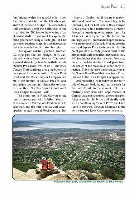
After reaching the meadow on the north side of Squaw Peak the trail turns south for the last 0.8 mile to the summit. This is a relatively open area with large
thickets of Gambel Oak and occasional groves of aspen. After a gentle climb the
Squaw Peak trail finally ends with a breathtaking view of Provo and Utah Lake to the west,
Cascade Mountain to the northeast, and Rock Canyon to the south.
Note to web developers: You may copy this material onto your site, but in return please include a link to my home page
www.utahtrails.com. Thank you, David Day (utahdavidday at gmail.com)
Click here to see more
trails near Salt Lake City
© Rincon Publishing Company, all rights reserved
|