Red Pine Lake Trail
excerpted from our book
Salt Lake City's Incredible Hiking and Biking Trails
pages 107-110
|
Buy book directly from the author!
Salt Lake City's Incredible Hiking and Biking Trails
- has access info for 73 trailheads
- 73 colorful trail maps
- 325 full color photographs
- loads of hiking tips
|
regularly $19.95
now on sale for only
$9.95
click here
for book orders
|
 Located in the heart of Utah’s Lone Peak Wilderness Area, Red Pine Lake definitely ranks among the prettiest of the Wasatch
Mountains’ high alpine lakes. It is a popular day or overnight hike and you are bound to meet many other trekkers along the way. But if you are looking
for more solitude there are also several possible side trips off the main trail that receive far fewer visitors.
Located in the heart of Utah’s Lone Peak Wilderness Area, Red Pine Lake definitely ranks among the prettiest of the Wasatch
Mountains’ high alpine lakes. It is a popular day or overnight hike and you are bound to meet many other trekkers along the way. But if you are looking
for more solitude there are also several possible side trips off the main trail that receive far fewer visitors.
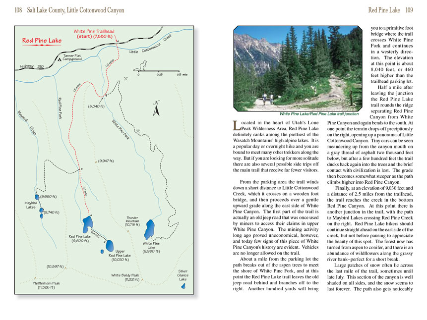
From the parking area the Red Pine Lake trail winds down a short distance to Little Cottonwood Creek, which it crosses on a wooden foot bridge, and then proceeds over a gentle
upward grade along the east side of White Pine Canyon. The first part of the trail is actually an old jeep road that was once used by miners to access their
claims in upper White Pine Canyon. The mining activity long ago proved uneconomical, however, and today few signs of this piece of White Pine Canyon's history
are evident. Vehicles are no longer allowed on the trail.
About a mile from the parking lot the path breaks out of the aspen trees to meet the shore of White Pine Fork, and at this point the Red Pine Lake trail leaves the
old jeep road behind and branches off to the right. Another hundred yards will bring you to a primitive foot bridge where the trail crosses White Pine Fork and
continues in a westerly direction. The elevation at this point is about 8,040 feet, or 460 feet higher than the trailhead parking lot.
Half a mile after leaving the junction the Red Pine Lake trail rounds the ridge separating Red Pine Canyon from White Pine Canyon and again bends to the south.
At one point the terrain drops off precipitously on the right, opening up a panorama of Little Cottonwood Canyon. Tiny cars can be seen meandering up from the
canyon mouth on a gray thread of asphalt two thousand feet below, but after a few hundred feet the
Red Pine Lake trail ducks back again into the trees and the brief contact
with civilization is lost. The grade then becomes somewhat steeper as the path climbs higher into Red Pine Canyon.
Finally, at an elevation of 9,030 feet and a distance of 2.5 miles from the trailhead, the trail reaches the creek in the bottom Red Pine Canyon. At this point
there is another junction in the trail, with the path to Maybird Lakes crossing Red Pine Creek on the right. Red Pine Lake hikers should continue straight ahead
on the east side of the creek, but not before pausing to appreciate the beauty of this spot. The forest now has turned from aspen to conifer, and there is an
abundance of wildflowers along the grassy river bank-perfect for a short break.
Large patches of snow often lie across the last mile of the trail, sometimes until late July. This section of the canyon is well shaded on all sides, and the
snow seems to last forever. The Red Pine Lake trail also gets noticeably steeper near the top of the canyon. Finally, at an elevation of 9,600 feet, the trail abruptly levels
off, and another five minutes of easy walking will bring you to the lake.
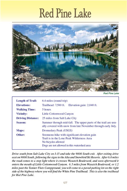
The setting of Red Pine Lake is exquisite. The rugged crest that separates Little Cottonwood and American Fork Canyons, as well as the Wasatch and Uinta National
Forests, lies just beyond the lake. White Baldy Peak (11,321 ft.) juts out prominently a mile to the southeast, and to the north, across Little Cottonwood Canyon,
Dromedary Peak (11,107 ft.) and Superior Peak (11,132 ft.) are clearly visible. The lake itself is about 600 feet across, with a smaller bay protruding on the
south end where the forest comes right to the water’s edge.
Upper Red Pine Lake
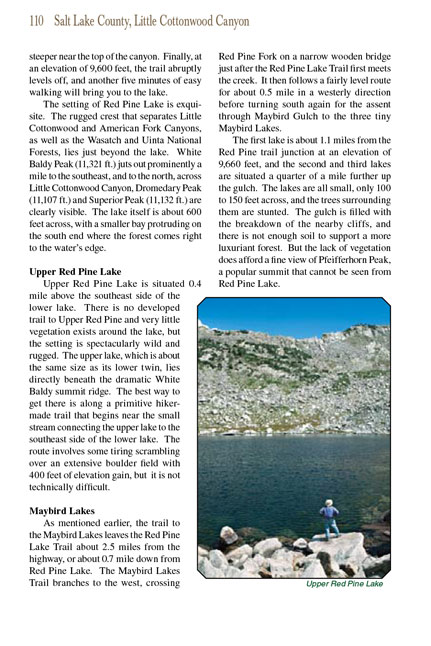
Upper Red Pine Lake is situated 0.4 mile above the southeast side of the lower lake. There is no developed trail to Upper Red Pine
Lake and very little vegetation
exists around the lake, but the setting is spectacularly wild and rugged. The upper lake, which is about the same size as its lower twin, lies directly beneath
the dramatic White Baldy summit ridge. The best way to get there is along a primitive hiker-made trail that begins near the small stream connecting the upper
lake to the southeast side of the lower lake. The route involves some tiring scrambling over an extensive boulder field with 400 feet of elevation gain, but
it is not technically difficult.
Maybird Lakes
As mentioned earlier, the trail to the Maybird Lakes leaves the Red Pine Lake Trail about 2.5 miles from the highway, or about 0.7 mile down from Red Pine Lake.
The Maybird Lakes Trail branches to the west, crossing Red Pine Fork on a narrow wooden bridge just after the Red Pine Lake Trail first meets the creek. It
then follows a fairly level route for about 0.5 mile in a westerly direction before turning south again for the assent through Maybird Gulch to the three tiny
Maybird Lakes.
The first lake is about 1.1 miles from the Red Pine trail junction at an elevation of 9,660 feet, and the second and third lakes are situated a quarter of a mile
further up the gulch. The lakes are all small, only 100 to 150 feet across, and the trees surrounding them are stunted. The gulch is filled with the breakdown
of the nearby cliffs, and there is not enough soil to support a more luxuriant forest. But the lack of vegetation does afford a fine view of Pfeifferhorn Peak,
a popular summit that cannot be seen from Red Pine Lake.
Note to web developers: You may copy this material onto your site, but in return please include a link to my home page
www.utahtrails.com. Thank you, David Day (utahdavidday
at gmail.com)
Click here to see more
trails near Salt Lake City
© Rincon Publishing Company, all rights reserved
|