Provo River Parkway Trail
Provo Canyon Section
excerpted from our book
Salt Lake City's Incredible Hiking and Biking Trails
pages 236-240
|
Buy book directly from the author!
Salt Lake City's Incredible Hiking and Biking Trails
- has access info for 73 trailheads
- 73 colorful trail maps
- 325 full color photographs
- loads of hiking tips
|
regularly $19.95
now on sale for only
$9.95
click here
for book orders
|
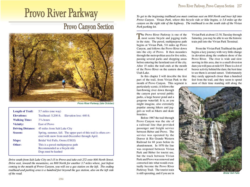
 The Provo River Parkway is one of the most scenic bicycle and jogging trails in the state. The paved, multipurpose path begins at
Vivian Park, 5.8 miles up Provo Canyon, and follows the Provo River down into the city of Provo. It then meanders through the metropolitan area for five miles,
passing several parks and shopping areas before entering the farmland east of the city. After 15 miles the trail ends at the mouth of the Provo River on the
eastern shore of Utah Lake.
The Provo River Parkway is one of the most scenic bicycle and jogging trails in the state. The paved, multipurpose path begins at
Vivian Park, 5.8 miles up Provo Canyon, and follows the Provo River down into the city of Provo. It then meanders through the metropolitan area for five miles,
passing several parks and shopping areas before entering the farmland east of the city. After 15 miles the trail ends at the mouth of the Provo River on the
eastern shore of Utah Lake.
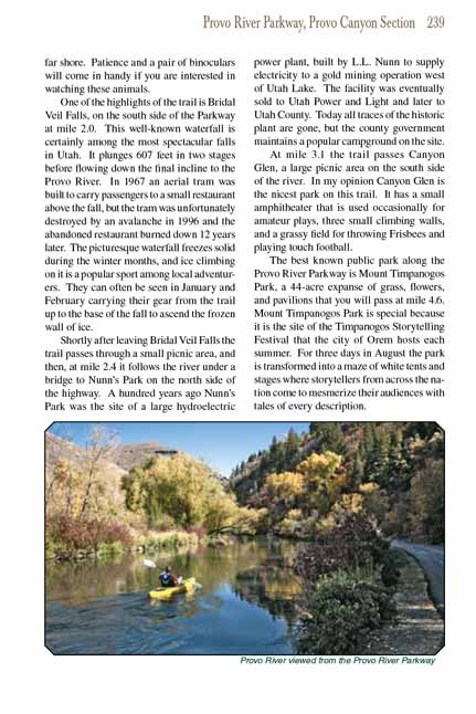
In this chapter I will describe the first part of the
Provo River Parkway Trail, from Vivian Park to the mouth of Provo Canyon. This segment is particularly scenic; it follows
the fast-flowing river down through the canyon past several public parks, a large beaver pond and a gorgeous waterfall. It is, as you might imagine, also
extremely popular among hikers and joggers as well as bikers and skate boarders.
Before 1967 the Provo River Parkway Trail through Provo Canyon was the site of a railroad line that provided passenger and freight service between Heber and Provo. The service
was operated by the Denver & Rio Grande Western Railroad for 68 years before its abandonment. In 1970 the line was reopened between Vivian Park and Heber
for tourist use, but the track between Vivian Park and Provo was removed and converted into what would eventually become the Provo River Parkway Trail. The
tourist train is still operating, and if you are in Vivian Park at about 12:30, Tuesday through Saturday, you may be able to see the historic train pull into
the Vivian Park Terminal.
From the Vivian Park Trailhead the Provo
River Parkway Trail begins a lazy journey with very little change in elevation along the southern shore of the Provo River. The river is
wide and slow moving in this area, due to a small diversion dam you will pass at mile 0.9. There is a lot of beaver activity behind the dam; the best time to
see them is around sunset. Unfortunately they rarely approach closer than a hundred feet from the trail, and they seem to spend most of their time standing
still along the far shore. Patience and a pair of binoculars will come in handy if you are interested in watching these animals.
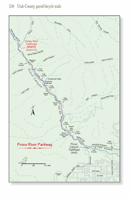
One of the highlights of the Provo River
Parkway Trail is Bridal Veil Falls, on the south side of the Parkway at mile 2.0. This well-known waterfall is certainly among the most
spectacular falls in Utah. It plunges 607 feet in two stages before flowing down the final incline to the Provo River. In 1967 an aerial tram was built to
carry passengers to a small restaurant above the fall, but the tram was unfortunately destroyed by an avalanche in 1996 and the abandoned restaurant burned
down 12 years later. The picturesque waterfall freezes solid during the winter months, and ice climbing on it is a popular sport among local adventurers.
They can often be seen in January and February carrying their gear from the trail up to the base of the fall to ascend the frozen wall of ice.
 Shortly after leaving Bridal Veil Falls the Provo
River Parkway Trail passes through a small picnic area, and then, at mile 2.4 it follows the river
under a bridge to Nunn’s Park on the north side of the highway. A hundred years ago Nunn’s Park was the site of a large hydroelectric power plant, built by L.L.
Nunn to supply electricity to a gold mining operation west of Utah Lake. The facility was eventually sold to Utah Power and Light and later to Utah County.
Today all traces of the historic plant are gone, but the county government maintains a popular campground on the site.
Shortly after leaving Bridal Veil Falls the Provo
River Parkway Trail passes through a small picnic area, and then, at mile 2.4 it follows the river
under a bridge to Nunn’s Park on the north side of the highway. A hundred years ago Nunn’s Park was the site of a large hydroelectric power plant, built by L.L.
Nunn to supply electricity to a gold mining operation west of Utah Lake. The facility was eventually sold to Utah Power and Light and later to Utah County.
Today all traces of the historic plant are gone, but the county government maintains a popular campground on the site.
At mile 3.1 the trail passes Canyon Glen, a large picnic area on the south side of the river. In my opinion Canyon Glen is the nicest park on this trail. It has
a small amphitheater that is used occasionally for amateur plays, three small climbing walls, and a grassy field for throwing Frisbees and playing touch football.
The best known public park along the Provo River Parkway
Trail is Mount Timpanogos Park, a 44-acre expanse of grass, flowers, and pavilions that you will pass at mile
4.6. Mount Timpanogos Park is special because it is the site of the Timpanogos Storytelling Festival that the city of Orem hosts each summer. For three days in
August the park is transformed into a maze of white tents and stages where storytellers from across the nation come to mesmerize their audiences with tales of
every description.
After you leave Mount Timpanogos Park start looking up on the north canyon wall. Soon you will see a long thread-like flume about 300 feet above the river that
eventually disappears into a tunnel near the canyon mouth. This flume was designed to feed water to another hydroelectric facility, the Olmsted Station, that
was built by L.L. Nunn in 1898. As you exit the canyon you will see the four large penstocks that carry water from the flume down to the turbine building just
a few hundred feet from the trail. Amazingly, this century-old installation was still being used as recently as 2013 by the Rocky Mountain Power company to
generate some of the electricity used by the city of Orem. When the river was full the plant could produce up to 12 megawatts of power-enough to supply about
3,000 homes.
The ride described here ends at the mouth of Provo Canyon in the parking lot near the Olmsted Power Station; however after crossing under 800 North Street the
Provo River Parkway Trail continues on into Provo along the east side of University Boulevard. A nice extension of this ride is to continue along the trail for another 1.1 miles
to Riverwoods, an up-scale shopping center in north Provo. Riverwoods has all of the usual movie theaters, restaurants and boutiques, but what really sets it
apart is its outdoor pedestrian mall. Free concerts are occasionally held there in the summer, as well as special events such as chalk drawing contests and
farmers' markets.
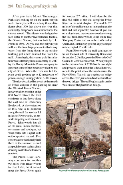
The Provo River Parkway Trail continues for another 9.5 miles from River Woods to Utah Lake, but it doesn’t meet the Provo River again for another 2.7 miles. I will
describe the final 6.8 miles of the trail along the Provo River in the next chapter. The middle 2.7 miles of the trail are not as interesting as the first and
last segments; however if you are on a bicycle you may want to continue along the trail from Riverwoods to the Plum Tree Shopping Center and on to the trail's
end at Utah Lake. In that way you can enjoy a single uninterrupted 15 mile ride.
From Riverwoods the Provo River Parkway Trail continues to follow the west side of University Boulevard for another 2.5 miles, past the Riverside Golf Course to 2230 North Street.
When you get to the intersection of 2230 North turn right and proceed west along the sidewalk for 0.3 mile to the point where the road crosses the Provo River.
You will see a pedestrian bridge across the river just a hundred feet north of the road bridge. The trail begins again on the west side of the pedestrian
bridge.
Note to web developers: You may copy this material onto your site, but in return please include a link to my home page
www.utahtrails.com. Thank you, David Day (utahdavidday
at gmail.com)
Click here to see more
trails near Salt Lake City
© Rincon Publishing Company, all rights reserved
|