Mount Raymond
via Butler Fork Trail
excerpted from our book
Salt Lake City's Incredible Hiking and Biking Trails
pages 72-74
|
Buy book directly from the author!
Salt Lake City's Incredible Hiking and Biking Trails
- has access info for 73 trailheads
- 73 colorful trail maps
- 325 full color photographs
- loads of hiking tips
|
regularly $19.95
now on sale for only
$9.95
click here
for book orders
|
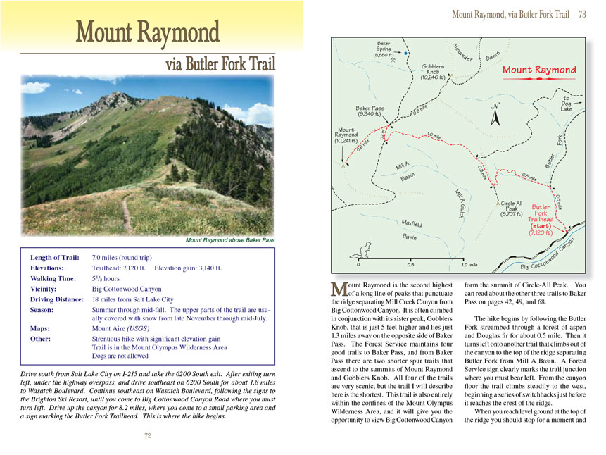
Mount Raymond is the second highest of a long line of peaks that punctuate the ridge separating Mill Creek Canyon from Big Cottonwood
Canyon. It is often climbed in conjunction with its sister peak, Gobblers Knob, that is just 5 feet higher and lies just 1.3 miles away on the opposite side of
Baker Pass. The Forest Service maintains four good trails to Baker Pass, and from Baker Pass there are two shorter spur trails that ascend to the summits of
Mount Raymond and Gobblers Knob. All four of the trails are very scenic, but the trail I will describe here is the shortest. This trail is also entirely
within the confines of the Mount Olympus Wilderness Area, and it will give you the opportunity to view Big Cottonwood Canyon form the summit of Circle-All
Peak. You can read about the other three trails to Baker Pass on pages 42, 49, and 68.
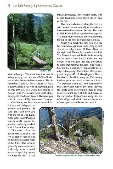
The Mount Raymond hike begins by following the Butler Fork streambed through a forest of aspen and Douglas fir for about 0.5 mile. Then it turns left onto another trail that
climbs out of the canyon to the top of the ridge separating Butler Fork from Mill A Basin. A Forest Service sign clearly marks the trail junction where you must
bear left. From the canyon floor the trail climbs steadily to the west, beginning a series of switchbacks just before it reaches the crest of the ridge.
When you reach level ground at the top of the ridge you should stop for a moment and look both ways. The main trail turns north to begin a long traverse around
Mill A Basin, but another fainter trail turns south. This is the trail to Circle-All Peak. Circle-All Peak is just 0.2 mile away with an elevation gain of only
150 feet, so it would be a shame to miss it. The five-minute walk south along the ridge to Circle-All Peak will reward you with nice views of Big Cottonwood
Canyon.
Continuing north on the main Mount Raymond trail for 0.3 mile will bring you to another trail junction. If you turn right here you will end up at Dog Lake, but to get to
Baker Pass and Mount Raymond you must turn left. Again, the junction is clearly marked with a Forest Service sign.
The next 1.2 miles across Mill A Basin to the top of Baker Pass is one of the most pleasant parts of this hike. The forest is generally more open here with only
an occasional grove of quaking aspen blocking the view. Baker Pass can be clearly seen from the basin, with Mount Raymond rising above the left side of the
pass.
Five minutes before reaching the pass you will come to an unmarked junction where a less-used trail departs on the left. This trail to Mill B North Fork
described on page 68. The main trail continues upward, reaching the top of the pass after another 0.2 mile.
When you reach the pass you will see two other more primitive trails going up each side of the ridge toward Gobblers Knob on the right and Mount Raymond on the
left. The Mount Raymond Trail climbs steadily up the grassy slope for 0.5 mile, but then comes to an obstacle that may give pause to some inexperienced hikers.
The route is blocked by a seemingly impassable knife-edge outcropping of limestone. (See photograph on page 45.) Although you will need both hands, the climb
along the 30-foot-long knife-edge is not nearly as bad as it looks. The exposure is minimal and, furthermore, this is the worst part of the climb. Beyond
the knife-edge outcropping there is more minor scrambling, with bits and pieces of the trail visible. Just continue along the crest of the ridge, and within
another five or ten minutes you should be on the summit.
Note to web developers: You may copy this material onto your site, but in return please include a link to my home page
www.utahtrails.com. Thank you, David Day (utahdavidday
at gmail.com)
Click here to see more
trails near Salt Lake City
© Rincon Publishing Company, all rights reserved
|