Malan's Basin Trail
excerpted from our book
Salt Lake City's Incredible Hiking and Biking Trails
pages 288-291
|
Buy book directly from the author!
Salt Lake City's Incredible Hiking and Biking Trails
- has access info for 73 trailheads
- 73 colorful trail maps
- 325 full color photographs
- loads of hiking tips
|
regularly $19.95
now on sale for only
$9.95
click here
for book orders
|
 Malanĺs Basin is a beautiful piece of privately owned alpine land below the western side of Mount Ogden. Although most
of the Malan's Basin Trail described here passes across Forest Service land, the basin itself is and has been privately owned for as long as anyone can remember.
In 2006 the current owner planned to build a resort in Malanĺs Basin with a gondola that would run from the city of Ogden, through the basin, to
Snow Basin Ski Resort on the east side of Mount Ogden. Fortunately for the hiking community that proposal appears to have died because of a lack
of funding, but there is still a very real possibility that the land might be developed at some point in the future. For now Malanĺs Basin is
nothing more or less than an enjoyable hike to a beautiful alpine basin in the mountains above Ogden.
Malanĺs Basin is a beautiful piece of privately owned alpine land below the western side of Mount Ogden. Although most
of the Malan's Basin Trail described here passes across Forest Service land, the basin itself is and has been privately owned for as long as anyone can remember.
In 2006 the current owner planned to build a resort in Malanĺs Basin with a gondola that would run from the city of Ogden, through the basin, to
Snow Basin Ski Resort on the east side of Mount Ogden. Fortunately for the hiking community that proposal appears to have died because of a lack
of funding, but there is still a very real possibility that the land might be developed at some point in the future. For now Malanĺs Basin is
nothing more or less than an enjoyable hike to a beautiful alpine basin in the mountains above Ogden.
It is interesting to note that between 1894 and 1906, a century before the recent proposal to build a resort in Malanĺs Basin, there actually was a
fully functioning resort in the area. The facility, built by Bartholomew Malan and his family, occupied about 10 acres and included a two story Malan
Heights Hotel, seven private cabins, and a small sawmill. The Malans charged $6.00/week for board and room plus $1.00 for the round trip wagon ride
from Ogden. The hotel, however, burned down after only 12 years of operation and was never rebuilt.
Most of the trail described below follows the old wagon road that was built by the Malans in 1892-1893. The road started in Ogden on the east end of
25th Street and, like the trail today, it ran up Taylor Canyon, across Malans Peak, and down into the basin. The wagon left at 8:15 each morning and
arrived at the resort 90 minutes later.
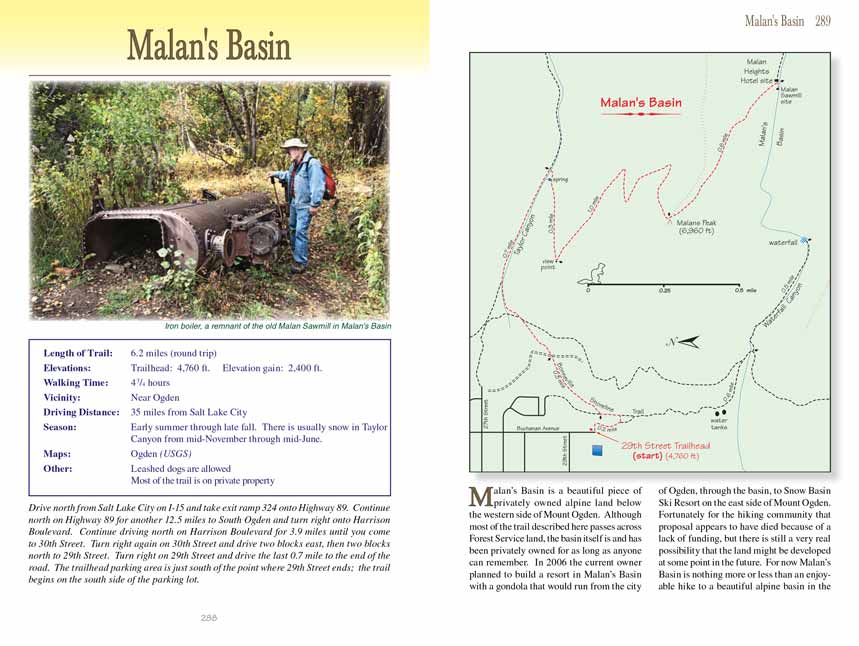
A hundred years of erosion has taken its toll, and today it is not obvious that the footpath you will be walking on was once a road. There is not much
evidence of the resort that once stood in the basin either, but, as I will describe later, you can still see an old boiler and parts of a steam engine
near the hotel site that were used by the sawmill.
The Malan's Basin Trail heads east from the trailhead and then turns south as it begins a 150-foot climb up to the Bonneville Shoreline Trail. When you reach the
junction, 0.2 mile from the trailhead, turn left. The Bonneville Trail at this point is actually an old road, but the road quickly runs through a
gate into private property. 150 feet before the gate, or about 100 yards after first turning onto the Bonneville Shoreline Trail you will see a
more primitive path departing on the right where you must turn to avoid the ôno trespassingö signs. After just 200 feet you will come to another
private property boundary, but this time there is a notice that the public is welcome.
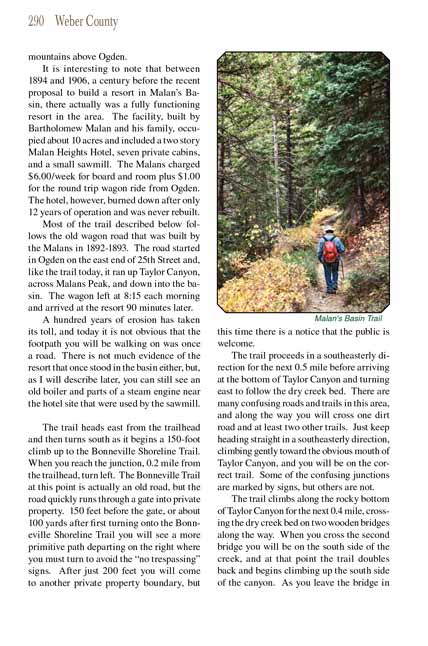
The Malan's Basin Trail proceeds in a southeasterly direction for the next 0.5 mile before arriving at the bottom of Taylor Canyon and turning east to follow the dry
creek bed. There are many confusing roads and trails in this area, and along the way you will cross one dirt road and at least two other trails. Just
keep heading straight in a southeasterly direction, climbing gently toward the obvious mouth of Taylor Canyon, and you will be on the correct trail.
Some of the confusing junctions are marked by signs, but others are not.
The trail climbs along the rocky bottom of Taylor Canyon for the next 0.4 mile, crossing the dry creek bed on two wooden bridges along the way. When
you cross the second bridge you will be on the south side of the creek, and at that point the
Malan's Basin Trail doubles back and begins climbing up the south side
of the canyon. As you leave the bridge in the bottom of the canyon look down on the north side of the trail. 250 feet after leaving the bridge you
will pass a large spring below the right side of the path.
After leaving the bottom of the canyon the
Malan's Basin Trail switches back four times before finally arriving at Malanĺs Peak 1.3 miles later. Most of the trail
is in a dense conifer forest, but as you approach the peak the forest becomes more open, giving you an occasional glimpse of Ben Lomond and other peaks
north along the Wasatch Front. At the first switchback, 0.3 mile from the canyon bottom, you will come to a particularly fine overlook point 1,200 feet
above the east side of Ogden. Many people stop at this point and go no farther.
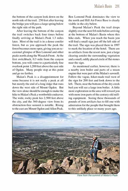
Malanĺs Peak is a disappointment for some because it is not really a peak at all but merely the end of a long ridge that runs down the west side of Mount
Ogden. But the view alone should be enough to make the hike to Malanĺs Peak a worthwhile endeavor. The wide, rocky peak lies 2,500 feet above the city,
and the 360-degree view from its obstruction-free summit is notable. Rising to the east are Mount Ogden and Allen Peak. Ben Lomond Peak dominates the
view to the north and Hill Air Force Base is clearly visible in the city below.
Beyond Malanĺs Peak the Malan's Basin Trail drops slightly over the next 0.6 mile before arriving at the bottom of Malanĺs Basin where this hike ends. When you reach
the basin you will find a small sign just off the left side of the trail. The sign was placed there in 1997 to mark the location of the hotel. There
are no artifacts from the resort now, just a large clearing amidst the surrounding vegetation and a small, oddly placed circle of flat stones near the
sign.
As mentioned earlier, however, there is a nearby iron boiler and parts of a steam engine that were part of the Malanĺs sawmill. Follow the vague,
hiker-made trail west of the sign for 200 feet and look down to the left. There, near the bottom of the dry creek bed you will see a large iron boiler.
A little more exploration in the area will reward you with more iron parts of the century-old milling equipment. Seeing these thousands of pounds of
iron artifacts has to fill one with admiration for the people that brought them to this unlikely place so many years ago.
Note to web developers: You may copy this material onto your site, but in return please include a link to my home page
www.utahtrails.com. Thank you, David Day (utahdavidday at gmail.com)
Click here to see more
trails near Salt Lake City
ę Rincon Publishing Company, all rights reserved
|