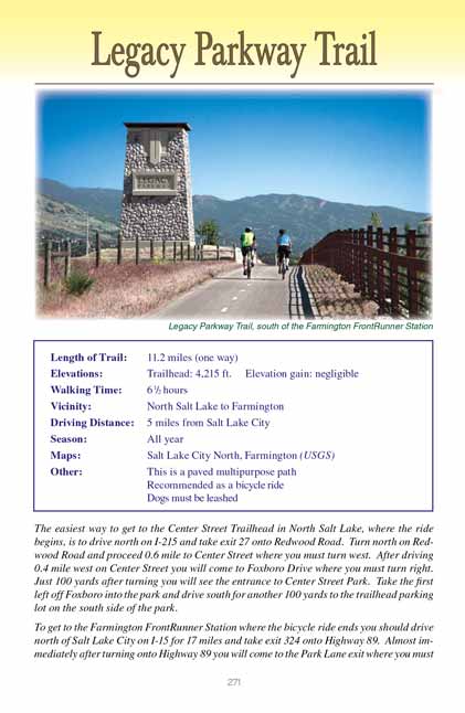
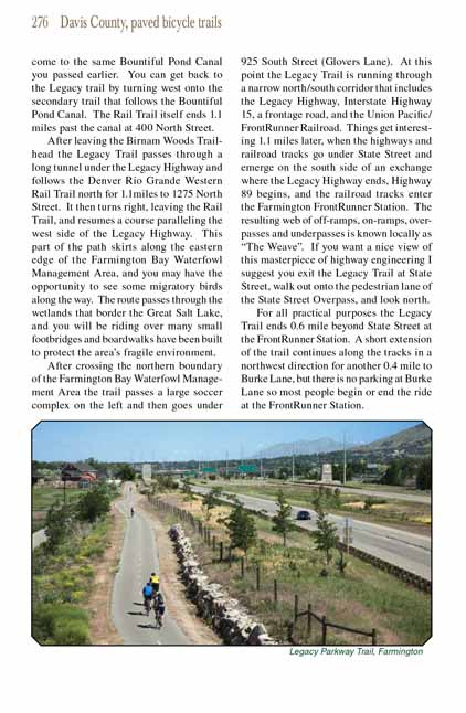
Legacy Parkway Trail
excerpted from our book
Salt Lake City's Incredible Hiking and Biking Trails
pages 271-276
|
Buy book directly from the author!
Salt Lake City's Incredible Hiking and Biking Trails
- has access info for 73 trailheads
- 73 colorful trail maps
- 325 full color photographs
- loads of hiking tips
|
regularly $19.95
now on sale for only
$9.95
click here
for book orders
|
 The Legacy Parkway Trail is the result of a legal compromise that was reached in 2005 between the Sierra Club and the State
of Utah regarding the construction of the controversial Legacy Highway on the eastern shore of the Great Salt Lake. Initial construction of the
long-planned highway began in 2001, but it was soon halted by a series of lawsuits and a ruling by the Federal Court of Appeals that said the state’s
Environmental Impact Statement was inadequate. Four more years of negotiations followed before a new agreement could be reached that allowed the
project to continue. The compromise agreement rerouted the road away from the most environmentally sensitive areas east of the Great Salt Lake and
created the 2,225-acre Legacy Nature Preserve between the highway and the lake. It also reduced the highway’s width from six lanes to four and
provided for the Legacy Parkway Trail to be built.
The Legacy Parkway Trail is the result of a legal compromise that was reached in 2005 between the Sierra Club and the State
of Utah regarding the construction of the controversial Legacy Highway on the eastern shore of the Great Salt Lake. Initial construction of the
long-planned highway began in 2001, but it was soon halted by a series of lawsuits and a ruling by the Federal Court of Appeals that said the state’s
Environmental Impact Statement was inadequate. Four more years of negotiations followed before a new agreement could be reached that allowed the
project to continue. The compromise agreement rerouted the road away from the most environmentally sensitive areas east of the Great Salt Lake and
created the 2,225-acre Legacy Nature Preserve between the highway and the lake. It also reduced the highway’s width from six lanes to four and
provided for the Legacy Parkway Trail to be built.
The Legacy Parkway project was completed in 2008, and the associated 14-mile-long Legacy Parkway Trail has since become one of the state’s most popular
bicycle paths; you won’t be able to ride far along this 14-mile trail without passing or being passed by other bicyclers. The trail also connects with
the Jordan River Parkway, making it possible to continue south to Salt Lake City’s North Temple Street along an uninterrupted, paved trail. Furthermore,
in Farmington the Legacy Trail also connects with the Denver and Rio Grande Western Rail Trail which goes north all the way to Roy. So a lot of variations
of the route described here are possible. (See pages 132-137 and 277-281.)
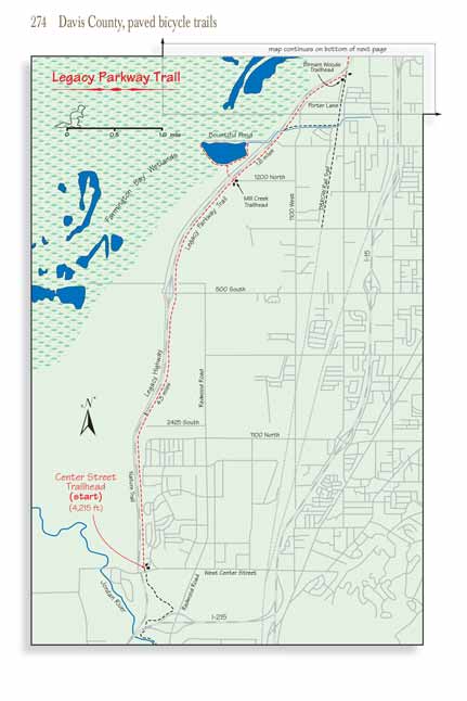
Initially the trail north of the Center Street Trailhead in North Salt Lake is not particularly interesting. It parallels closely along the east side of
the Legacy Highway, and although it passes Foxboro Park and several other open areas the vegetation is sparse and there is not a great deal of shade. At
1.6 miles you will come to the 2425 South Trailhead in Woods Cross where there is also an overpass for bicycles to cross to the west side of the highway.
The main trail remains on the east side of the highway, but the overpass was built to allow access to an unpaved nature trail that runs for the next three
miles along the opposite side of the road. In theory the nature trail could have been a nice addition to the Legacy Parkway Trail, but it is seldom used.
After completion a chain link fence was erected to keep hikers out of the Legacy Nature Preserve on the west side of the highway, so now most of the
“nature trail” is simply an uninteresting dirt path that runs through the narrow strip of land between the fence and the highway.
 The trail passes under 500 South Street in Woods Cross 1.4 miles north of the 2425 South Trailhead. There is also a ramp at
this point that leads up to the south side of 500 South Street and across the highway bridge to the 500 South Trailhead on the west side of the Legacy
Highway. The Legacy Parkway Nature Trail ends at this trailhead.
The trail passes under 500 South Street in Woods Cross 1.4 miles north of the 2425 South Trailhead. There is also a ramp at
this point that leads up to the south side of 500 South Street and across the highway bridge to the 500 South Trailhead on the west side of the Legacy
Highway. The Legacy Parkway Nature Trail ends at this trailhead.
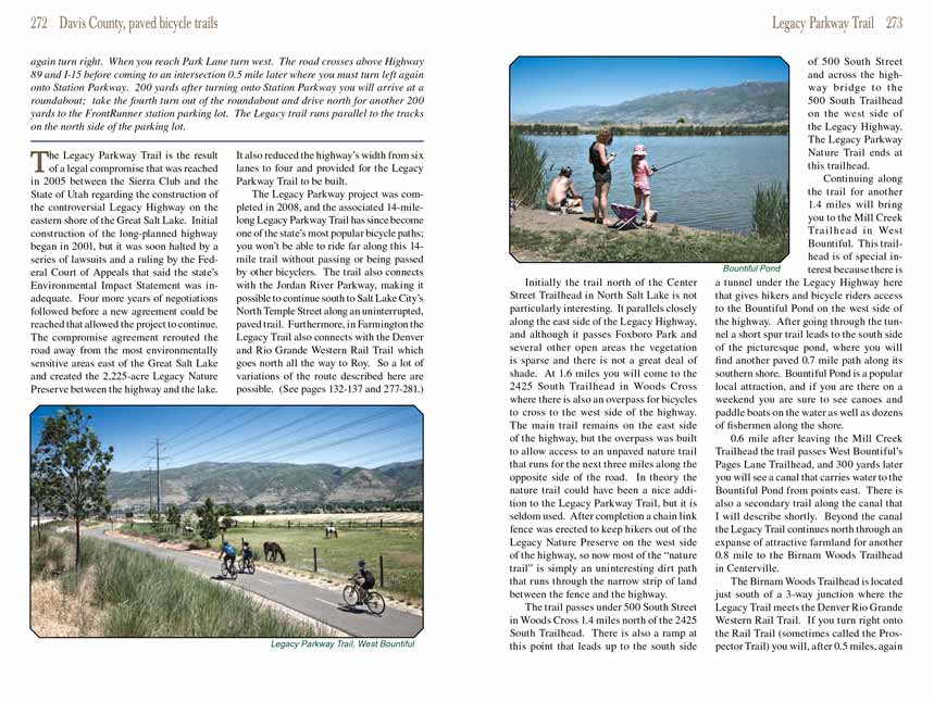
Continuing along the Legacy Parkway Trail for another 1.4 miles will bring you to the Mill Creek Trailhead in West Bountiful. This trailhead is of special interest because
there is a tunnel under the Legacy Highway here that gives hikers and bicycle riders access to the Bountiful Pond on the west side of the highway. After
going through the tunnel a short spur trail leads to the south side of the picturesque pond, where you will find another paved 0.7 mile path along its
southern shore. Bountiful Pond is a popular local attraction, and if you are there on a weekend you are sure to see canoes and paddle boats on the water
as well as dozens of fishermen along the shore.
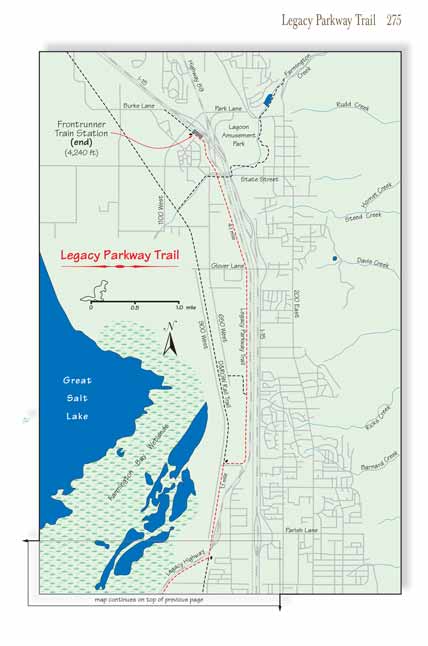
0.6 mile after leaving the Mill Creek Trailhead the
Legacy Parkway Trail passes West Bountiful’s Pages Lane Trailhead, and 300 yards later you will see a canal that carries
water to the Bountiful Pond from points east. There is also a secondary trail along the canal that I will describe shortly. Beyond the canal the Legacy
Parkway Trail continues north through an expanse of attractive farmland for another 0.8 mile to the Birnam Woods Trailhead in Centerville.
The Birnam Woods Trailhead is located just south of a 3-way junction where the Legacy
Parkway Trail meets the Denver Rio Grande Western Rail Trail. If you turn
right onto the Rail Trail (sometimes called the Prospector Trail) you will, after 0.5 miles, again come to the same Bountiful Pond Canal you passed earlier.
You can get back to the Legacy trail by turning west onto the secondary trail that follows the Bountiful Pond Canal. The Rail Trail itself ends 1.1 miles
past the canal at 400 North Street.
 After leaving the Birnam Woods Trailhead the Legacy Trail passes through a long tunnel under the Legacy Highway and follows
the Denver Rio Grande Western Rail Trail north for 1.1miles to 1275 North Street. It then turns right, leaving the Rail Trail, and resumes a course
paralleling the west side of the Legacy Highway. This part of the path skirts along the eastern edge of the Farmington Bay Waterfowl Management Area,
and you may have the opportunity to see some migratory birds along the way. The route passes through the wetlands that border the Great Salt Lake, and
you will be riding over many small footbridges and boardwalks have been built to protect the area’s fragile environment.
After leaving the Birnam Woods Trailhead the Legacy Trail passes through a long tunnel under the Legacy Highway and follows
the Denver Rio Grande Western Rail Trail north for 1.1miles to 1275 North Street. It then turns right, leaving the Rail Trail, and resumes a course
paralleling the west side of the Legacy Highway. This part of the path skirts along the eastern edge of the Farmington Bay Waterfowl Management Area,
and you may have the opportunity to see some migratory birds along the way. The route passes through the wetlands that border the Great Salt Lake, and
you will be riding over many small footbridges and boardwalks have been built to protect the area’s fragile environment.
After crossing the northern boundary of the Farmington Bay Waterfowl Management Area the trail passes a large soccer complex on the left and then goes under
925 South Street (Glovers Lane). At this point the Legacy Trail is running through a narrow north/south corridor that includes the Legacy Highway, Interstate
Highway 15, a frontage road, and the Union Pacific/FrontRunner Railroad. Things get interesting 1.1 miles later, when the highways and railroad tracks go
under State Street and emerge on the south side of an exchange where the Legacy Highway ends, Highway 89 begins, and the railroad tracks enter the
Farmington FrontRunner Station. The resulting web of off-ramps, on-ramps, overpasses and underpasses is known locally as “The Weave”. If you want
a nice view of this masterpiece of highway engineering I suggest you exit the Legacy Trail at State Street, walk out onto the pedestrian lane of the
State Street Overpass, and look north.
For all practical purposes the Legacy Trail ends 0.6 mile beyond State Street at the FrontRunner Station. A short extension of the trail continues along
the tracks in a northwest direction for another 0.4 mile to Burke Lane, but there is no parking at Burke Lane so most people begin or end the ride at the
FrontRunner Station.
Note to web developers: You may copy this material onto your site, but in return please include a link to my home page
www.utahtrails.com. Thank you, David Day (utahdavidday at gmail.com)
Click here to see more
trails near Salt Lake City
© Rincon Publishing Company, all rights reserved
|