Lake Blanche Trail
excerpted from our book
Salt Lake City's Incredible Hiking and Biking Trails
pages 65-67
|
Buy book directly from the author!
Salt Lake City's Incredible Hiking and Biking Trails
- has access info for 73 trailheads
- 73 colorful trail maps
- 325 full color photographs
- loads of hiking tips
|
regularly $19.95
now on sale for only
$9.95
click here
for book orders
|
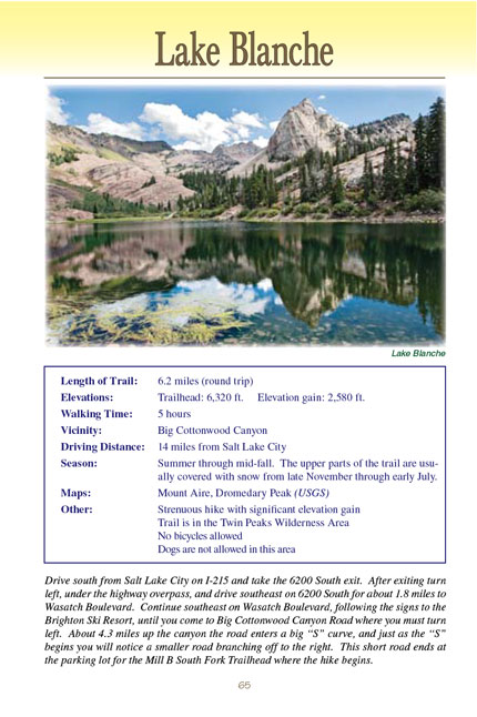
Lake Blanche is one of the most popular hikes in the Salt Lake City area, not only because the walk is relatively short and the
trailhead easy to get to, but because of the scenic beauty and the geologic attractions within the Lake Blanche Basin. Blanche and its two sister lakes, Florence
and Lillian, sit in a high alpine basin that was dug out by a glacier during the last ice age. Long straight scratch marks and deep polished grooves, etched
out by the glacier, are still clearly visible on the stone surrounding the lakes. Picturesque Sundial Peak (10,320 ft.), that the Wasatch Mountain Club uses
as its emblem, rises abruptly from the south shore of Lake Blanche, and Dromedary Peak (11,170 ft.) is only a mile to the southwest. Blanche, its two sister
lakes, Dromedary Peak, and the Sundial are all part of Utah's 11,300-acre Twin Peaks Wilderness Area.
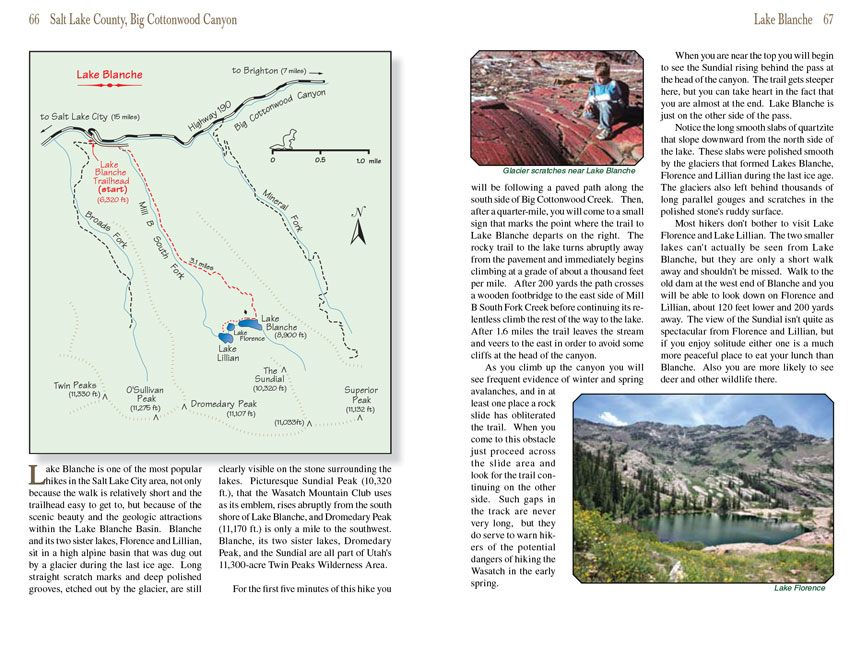
For the first five minutes of this hike you will be following a paved path along the south side of Big Cottonwood Creek. Then, after a quarter-mile, you will
come to a small sign that marks the point where the Lake Blanche trail departs on the right. The rocky trail to the lake turns abruptly away from the pavement
and immediately begins climbing at a grade of about a thousand feet per mile. After 200 yards the path crosses a wooden footbridge to the east side of Mill B
South Fork Creek before continuing its relentless climb the rest of the way to the lake. After 1.6 miles the
Lake Blanche trail leaves the stream and veers to the east in
order to avoid some cliffs at the head of the canyon.
As you climb up the canyon you will see frequent evidence of winter and spring avalanches, and in at least one place a rock slide has obliterated the trail. When
you come to this obstacle just proceed across the slide area and look for the trail continuing on the other side. Such gaps in the track are never very long, but
they do serve to warn hikers of the potential dangers of hiking the Wasatch in the early spring.
When you are near the top you will begin to see the Sundial rising behind the pass at the head of the canyon. The trail gets steeper here, but you can take heart
in the fact that you are almost at the end. Lake Blanche is just on the other side of the pass.
Notice the long smooth slabs of quartzite that slope downward from the north side of the lake. These slabs were polished smooth by the glaciers that formed Lakes
Blanche, Florence and Lillian during the last ice age. The glaciers also left behind thousands of long parallel gouges and scratches in the polished stone's
ruddy surface.
Most hikers don't bother to visit Lake Florence and Lake Lillian. The two smaller lakes can't actually be seen from Lake Blanche, but they are only a short walk
away and shouldn't be missed. Walk to the old dam at the west end of Lake Blanche and you will be able to look down on Florence and Lillian, about 120 feet lower and
200 yards away. The view of the Sundial isn't quite as spectacular from Florence and Lillian, but if you enjoy solitude either one is a much more peaceful place
to eat your lunch than Blanche. Also you are more likely to see deer and other wildlife there.
Note to web developers: You may copy this material onto your site, but in return please include a link to my home page
www.utahtrails.com. Thank you, David Day (utahdavidday
at gmail.com)
Click here to see more
trails near Salt Lake City
© Rincon Publishing Company, all rights reserved
|