Jordan River Parkway Trail
Salt Lake City to Taylorsville
excerpted from our book
Salt Lake City's Incredible Hiking and Biking Trails
pages 138-143
|
Buy book directly from the author!
Salt Lake City's Incredible Hiking and Biking Trails
- has access info for 73 trailheads
- 73 colorful trail maps
- 325 full color photographs
- loads of hiking tips
|
regularly $19.95
now on sale for only
$9.95
click here
for book orders
|
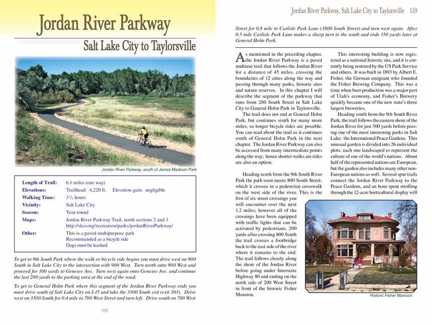
 As mentioned in the preceding chapter, the Jordan River Parkway
Trail is a paved multiuse trail that follows the Jordan River for a distance of 45 miles, crossing
the boundaries of 12 cities along the way and passing through many parks, historic sites and nature reserves. In this chapter I will describe the segment
of the parkway that runs from 200 South Street in Salt Lake City to General Holm Park in Taylorsville.
As mentioned in the preceding chapter, the Jordan River Parkway
Trail is a paved multiuse trail that follows the Jordan River for a distance of 45 miles, crossing
the boundaries of 12 cities along the way and passing through many parks, historic sites and nature reserves. In this chapter I will describe the segment
of the parkway that runs from 200 South Street in Salt Lake City to General Holm Park in Taylorsville.
The Jordan River Parkway Trail does not end at General Holm Park, but continues south for many more miles, so longer bicycle rides are possible. You can read about the trail as
it continues south of General Holm Park in the next chapter. The Jordan River Parkway
Trail can also be accessed from many intermediate points along the way;
hence shorter walks are rides are also an option.
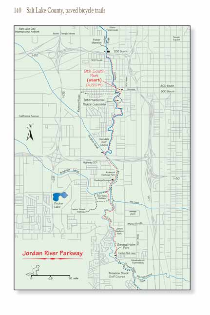
Heading north from the 9th South River Park the
Jordan River Parkway Trail soon meets 800 South Street, which it crosses in a pedestrian crosswalk on the west side of the river.
This is the first of six street crossings you will encounter over the next 1.2 miles; however all of the crossings have been equipped with traffic lights
that can be activated by pedestrians. 200 yards after crossing 800 South the trail crosses a footbridge back to the east side of the river where it remains
to the end. The Jordan River Parkway Trail follows closely along the shore of the Jordan River before going under Interstate Highway 80 and ending on the north side of 200
West Street in front of the historic Fisher Mansion.
This interesting building is now registered as a national historic site, and it is currently being restored by the US Park Service and others. It was built
in 1893 by Albert E. Fisher, the German emigrant who founded the Fisher Brewing Company. This was a time when beer production was a major part of Utah’s
economy, and Fisher’s Brewery quickly became one of the new state’s three largest breweries.
Heading south from the 9th South River Park, the
Jordan River Parkway Trail follows the eastern shore of the Jordan River for just 300 yards before passing one of the most
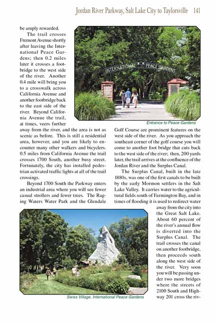
interesting parks in Salt Lake: the International Peace Gardens. This unusual garden is divided into 26 individual plots, each one landscaped to represent
the culture of one of the world’s nations. About half of the represented nations are European, but the garden also includes many other non-European nations
as well. Several spur trails connect the Jordan River Parkway Trail to the Peace Gardens, and an hour spent strolling through the 12-acre horticultural display
will be amply rewarded.
 The Jordan River Parkway Trail crosses Fremont Avenue shortly after leaving the International Peace Gardens; then 0.2 miles later it crosses a footbridge to the west side of
the river. Another 0.4 mile will bring you to a crosswalk across California Avenue and another footbridge back to the east side of the river. Beyond
California Avenue the trail, at times, veers further away from the river, and the area is not as scenic as before. This is still a residential area,
however, and you are likely to encounter many other walkers and bicyclers. 0.5 miles from California Avenue the trail crosses 1700 South, another busy
street. Fortunately, the city has installed pedestrian activated traffic lights at all of the trail crossings.
The Jordan River Parkway Trail crosses Fremont Avenue shortly after leaving the International Peace Gardens; then 0.2 miles later it crosses a footbridge to the west side of
the river. Another 0.4 mile will bring you to a crosswalk across California Avenue and another footbridge back to the east side of the river. Beyond
California Avenue the trail, at times, veers further away from the river, and the area is not as scenic as before. This is still a residential area,
however, and you are likely to encounter many other walkers and bicyclers. 0.5 miles from California Avenue the trail crosses 1700 South, another busy
street. Fortunately, the city has installed pedestrian activated traffic lights at all of the trail crossings.
Beyond 1700 South the Jordan River Parkway
Trail enters an industrial area where you will see fewer casual strollers and fewer trees. The Raging Waters Water Park and
the Glendale Golf Course are prominent features on the west side of the river. As you approach the southeast corner of the golf course you will come
to another foot bridge that cuts back to the west side of the river; then, 200 yards later, the trail arrives at the confluence of the Jordan River
and the Surplus Canal.
The Surplus Canal, built in the late 1880s, was one of the first canals to be built by the early Mormon settlers in the Salt Lake Valley. It carries
water to the agricultural fields south of Farmington Bay, and in times of flooding it is used to redirect water away from the city into the Great Salt
Lake. About 60 percent of the river’s annual flow is diverted into the Surplus Canal. The
Jordan River Parkway Trail crosses the canal on another footbridge, then proceeds
south along the west side of the river. Very soon you will be passing under two more bridges where the streets of 2100 South and Highway 201 cross the
river. Highway 201 also marks the boundary between Salt Lake City and West Valley City to the south.
The course of the Jordan River has been massively reengineered south of the Surplus Canal, primarily for reasons of flood control, and the river’s original
meanders have been mostly eliminated. Beyond the 2100 South Street bridge the waterway is more of an extension of the canal than the natural river, and
much of the scenic beauty that the lazy stream earlier possessed is gone. Furthermore, this is an industrial area with few trees and parks, and although
the paved trail is in excellent condition it is lamentably unattractive.
 To make matters worse, there is sometimes a bad smell near the water in this area. The problem is not nearly as bad
as it once was, but pollution in the Jordan River has been a major problem for decades. Fifty years ago the river was heavily contaminated by raw sewage,
agricultural runoff and mining wastes, but now, thanks to the 1972 Clean Water Act and other similar environmental laws, American rivers are much less
polluted than they once were. The Jordan River is still not pristine, but it has made a dramatic comeback.
To make matters worse, there is sometimes a bad smell near the water in this area. The problem is not nearly as bad
as it once was, but pollution in the Jordan River has been a major problem for decades. Fifty years ago the river was heavily contaminated by raw sewage,
agricultural runoff and mining wastes, but now, thanks to the 1972 Clean Water Act and other similar environmental laws, American rivers are much less
polluted than they once were. The Jordan River is still not pristine, but it has made a dramatic comeback.
0.5 mile beyond the 2100 South Street bridge the
Jordan River Parkway Trail passes Redwood Trailhead Park, a small but welcome oasis of trees and grass on the west side of the
river. As the name suggests, this park can be used as a convenient access point to the Jordan River Parkway
Trail. There is also a pleasant loop trail here
that begins by crossing the river on a footbridge to meet another trail on the east side of the river. That trail leads to another bridge 1.1 miles
further south that bicycle riders can use to cross back over the river and complete the loop (see map on page 140). The total distance of the loop
trail is 2.4 miles.
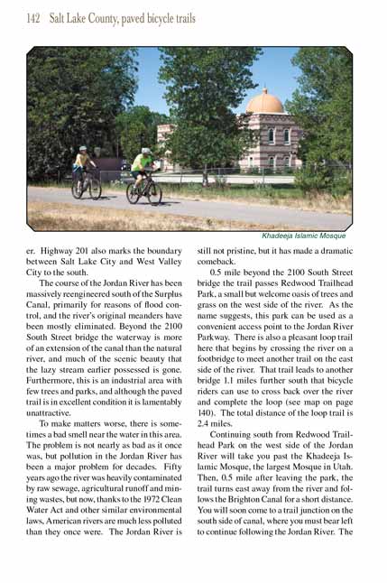
Continuing south from Redwood Trailhead Park on the west side of the Jordan River will take you past the Khadeeja Islamic Mosque, the largest Mosque in
Utah. Then, 0.5 mile after leaving the park, the Jordan River Parkway Trail turns east away from the river and follows the Brighton Canal for a short distance. You will
soon come to a trail junction on the south side of canal, where you must bear left to continue following the Jordan River. The trail on the right
continues following the Brighton Canal for another 0.3 mile, then turns south along the edge of the adjacent wetlands for 0.4 mile. It finally turns
again to the west and ends 0.3 mile later at West Valley City’s Lester Street Trailhead. The trailhead is located on the southeast side of the Redwood
Park parking area, just south of the baseball diamonds.
Back on the Jordan River Parkway, the trail continues along the boundary of West Valley City for 0.5 mile before crossing a footbridge into South Salt
Lake City on the east side. You will find this section of the trail to be significantly more attractive that before. More industrial buildings can
still be seen to the east, but the area on the river’s western shore is primarily wetlands. There is more vegetation along this segment, and the river
seems to be following close to its original meandering course. After following the river for another 0.9 mile the trail passes under a bridge at 3300
South Street and arrives at James Madison (Oxbow) Park. This small park on the boundary between West Valley City and South Salt Lake is also where
the James Madison Trailhead is located.
As you proceed south along the trail from James Madison Park the scenery continues to get better and better. Most of the industry of South Salt Lake is
north of 3300 South Street, and over the next mile the Jordan River Parkway Trail is often surrounded by trees. Also West Valley City actively prevents most development
along the part of the river that it controls, and since the boundary between West Valley and South Salt Lake generally lies a few hundred feet east of
the riverbed in this area West Valley has jurisdiction over both shores. The results of West Valley’s conservationist efforts have made this section
of the Jordan River Parkway Trail a very pleasant bicycle ride.
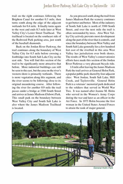
1.0 mile after leaving the James Madison Park the
Jordan River Parkway Trail arrives at General Holm Park, a popular public park shared by four adjacent cites: West Jordan,
South Salt Lake, Mill Creek, and Taylorsville. General Holm Park is a veterans’ memorial park dedicated to the soldiers that served in World War Two.
It was named after Jeanne M. Holm who served in the Women’s Army Corps during the war and later as an officer in the Air Force. In 1973 Holm became
the first woman in the United States Armed Forces to attain the rank of major general.
Note to web developers: You may copy this material onto your site, but in return please include a link to my home page
www.utahtrails.com. Thank you, David Day (utahdavidday
at gmail.com)
Click here to see more
trails near Salt Lake City
© Rincon Publishing Company, all rights reserved
|