Gobblers Knob
via Alexander Basin Trail
excerpted from our book
Salt Lake City's Incredible Hiking and Biking Trails
pages 49-53
|
Buy book directly from the author!
Salt Lake City's Incredible Hiking and Biking Trails
- has access info for 73 trailheads
- 73 colorful trail maps
- 325 full color photographs
- loads of hiking tips
|
regularly $19.95
now on sale for only
$9.95
click here
for book orders
|
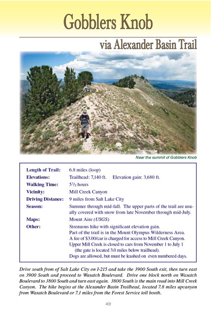
 Gobblers Knob is the highest point on the ridge separating Mill Creek Canyon from Big Cottonwood Canyon, and the view from the
top is exceptional. It lies on the boundary of the Mount Olympus Wilderness Area just above the north-facing bowl of picturesque Alexander Basin. Gobblers
Knob’s proximity to Alexander Basin is in large part why it is such a delightful place, but, regrettably, it was also this proximity that prevented it, in
1984, from being wholly included in the Mount Olympus Wilderness Area. As a result there is now a very real possibility that someday the view from the peak
will be marred by the presence of ski lifts on its northern slopes.
Gobblers Knob is the highest point on the ridge separating Mill Creek Canyon from Big Cottonwood Canyon, and the view from the
top is exceptional. It lies on the boundary of the Mount Olympus Wilderness Area just above the north-facing bowl of picturesque Alexander Basin. Gobblers
Knob’s proximity to Alexander Basin is in large part why it is such a delightful place, but, regrettably, it was also this proximity that prevented it, in
1984, from being wholly included in the Mount Olympus Wilderness Area. As a result there is now a very real possibility that someday the view from the peak
will be marred by the presence of ski lifts on its northern slopes.
A fierce political battle was fought in the early 1980s over the boundaries of the proposed Mount Olympus Wilderness Area. Protection of Alexander Basin was a
high priority among Utah’s environmentalists, but since the basin is used by helicopter skiers they were opposed by the state’s skiing industry. In the end the
skiers won, and the scenic glacial cirque was excluded. The boundaries of the Mount Olympus Wilderness Area are now distorted by a huge gouge on the eastern
side where Alexander Basin lies. Not only is the basin still used by helicopter skiers, but, even worse, it could easily become part of a future ski resort
in upper Mill Creek Canyon. Proposals for such a resort have already been submitted to the Forest Service.
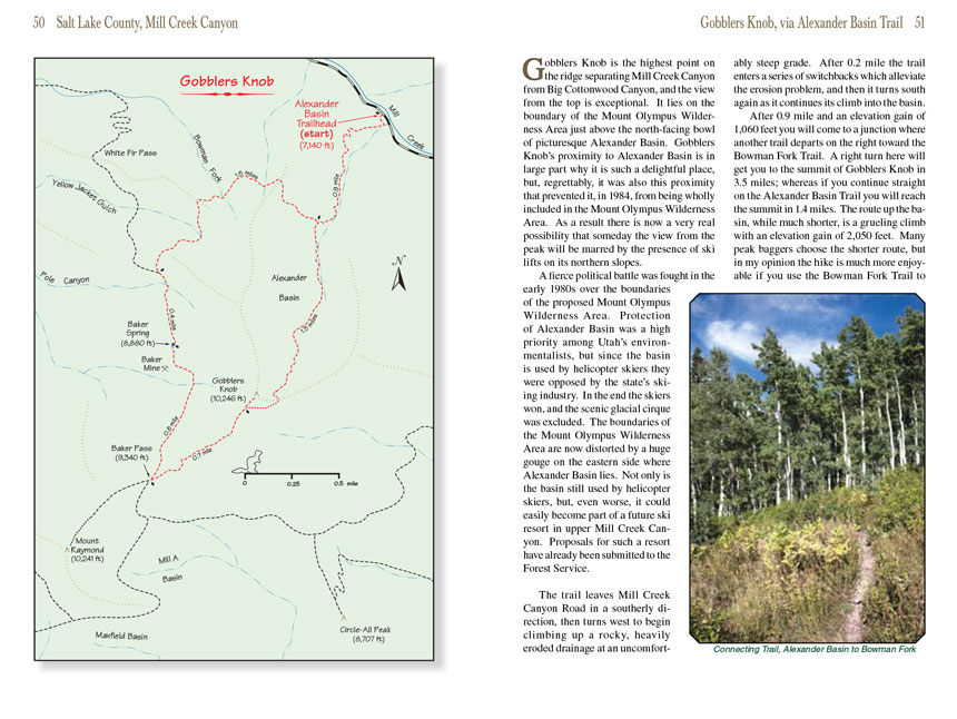
The trail leaves Mill Creek Canyon Road in a southerly direction, then turns west to begin climbing up a rocky, heavily eroded drainage at an uncomfortably steep
grade. After 0.2 mile the trail enters a series of switchbacks which alleviate the erosion problem, and then it turns south again as it continues its climb into
the basin.
After 0.9 mile and an elevation gain of 1,060 feet you will come to a junction where another trail departs on the right toward the Bowman Fork Trail. A right
turn here will get you to the summit of Gobblers Knob in 3.5 miles; whereas if you continue straight on the Alexander Basin Trail you will reach the summit in
1.4 miles. The route up the basin, while much shorter, is a grueling climb with an elevation gain of 2,050 feet. Many peak baggers choose the shorter route,
but in my opinion the hike to the summit of Gobblers Knob is much more enjoyable if you use the Bowman Fork Trail to access the summit and then return through Alexander Basin to the trailhead.
That is the route I will describe here.
 Turning right at the junction, the trail winds westward, gaining a total of 470 feet and loosing 560 feet as it crosses three
drainages on the north side of the mountain. Finally, 1.6 miles after leaving Alexander Basin, you will come to another junction where the Bowman Trail departs
on the left toward Mount Raymond and Gobblers Knob.
Turning right at the junction, the trail winds westward, gaining a total of 470 feet and loosing 560 feet as it crosses three
drainages on the north side of the mountain. Finally, 1.6 miles after leaving Alexander Basin, you will come to another junction where the Bowman Trail departs
on the left toward Mount Raymond and Gobblers Knob.
Continuing upward on the Bowman Fork Trail toward Gobblers Knob for another 0.4 mile will bring you to Baker Spring, the site of an old mining camp. There was
a cabin here until the 1980s, but unfortunately it burned down and now there is no trace left of it. If you look around, however, you will see remnants of the
mining activity. Baker Mine is about 300 yards south of the spring, and there are remains of a smaller mine above the trail. Gobblers Knob is said to have
gotten its name from the noise made by a flock of turkeys that were once kept by miners living in the area.
Beyond Baker Spring the scenery continues to become more and more inspiring. As you pass the 9,000 foot level the forest opens up to some fine views of Gobblers
Knob, Mount Raymond, and the Great Salt Lake. When you reach the summit of Baker Pass, 0.8 mile later, you will be greeted by a panorama of the Twin Peaks
Wilderness Area south of Big Cottonwood Canyon. On the southwest side of the pass is Mount Raymond, and on the opposite side is Gobblers Knob-both rising
about 900 feet above the saddle. At the crest of the pass you will see two other trails taking off in either direction along the ridge to the two nearby
summits. Turn east here for the climb to the top of Gobblers Knob. (See pages 42 and 72 for descriptions of the trail up Mount Raymond.)
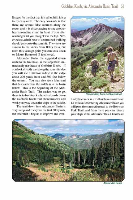
The trail up Gobblers Knob is not maintained, but it is well used and easy to follow. Except for the fact that it is all uphill, it is a fairly easy walk. The
only downside is that there are several false summits along the route, and it is discouraging to see another heart-pounding climb in front of you after reaching
what you thought was the top. Nevertheless, a half hour of determined walking should get you to the summit. The views are similar to the views from Baker Pass,
but from this vantage point you can look down on Mount Raymond (5 feet lower).
Alexander Basin, the suggested return route to the trailhead, is the large bowl immediately northeast of Gobblers Knob. If you look directly east along the
summit ridge you will see a shallow saddle in the ridge about 200 yards from and 300 feet below the summit. You may also see a faint trail that descends from
the saddle into the basin below. This is the beginning of the Alexander Basin Trail. The easiest way to get there is to backtrack a hundred yards down the
Gobblers Knob trail, then turn east and work your way down the slope to the saddle.
The trail down into Alexander Basin is very steep and rocky for the first 300 yards, but after that it begins to improve and eventually becomes an excellent
hiker-made trail. 1.1 miles after entering Alexander Basin you will pass the connecting trail to the Bowman Fork Trail, and from there you can retrace your
steps to the Alexander Basin Trailhead.
Note to web developers: You may copy this material onto your site, but in return please include a link to my home page
www.utahtrails.com. Thank you, David Day (utahdavidday
at gmail).com
Click here to see more
trails near Salt Lake City
© Rincon Publishing Company, all rights reserved
|