Elephant Rock Trail
excerpted from our book
Salt Lake City's Incredible Hiking and Biking Trails
pages 246-248
|
Buy book directly from the author!
Salt Lake City's Incredible Hiking and Biking Trails
- has access info for 73 trailheads
- 73 colorful trail maps
- 325 full color photographs
- loads of hiking tips
|
regularly $19.95
now on sale for only
$9.95
click here
for book orders
|
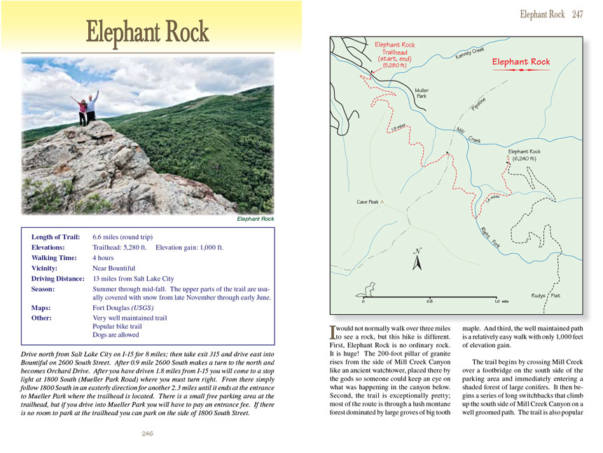
I would not normally walk over three miles to see a rock, but this hike is different. First, Elephant Rock is no ordinary rock.
It is huge! The 200-foot pillar of granite rises from the side of Mill Creek Canyon like an ancient watchtower, placed there by the gods so someone could
keep an eye on what was happening in the canyon below. Second, the Elephant
Rock Trail is exceptionally pretty; most of the route is through a lush montane forest
dominated by large groves of big tooth maple. And third, the well maintained path is a relatively easy walk with only 1,000 feet of elevation gain.
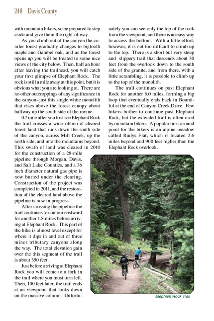
The Elephant Rock Trail begins by crossing Mill Creek over a footbridge on the south side of the parking area and immediately entering a shaded forest of large conifers.
It then begins a series of long switchbacks that climb up the south side of Mill Creek Canyon on a well groomed path. The trail is also popular with
mountain bikers, so be prepared to step aside and give them the right-of-way.
As you climb out of the canyon the conifer forest gradually changes to bigtooth maple and Gambel oak, and as the forest opens up you will be treated to some
nice views of the city below. Then, half an hour after leaving the trailhead, you will catch your first glimpse of Elephant Rock. The rock is still a mile
away at this point, but it is obvious what you are looking at. There are no other outcroppings of any significance in the canyon-just this single white
monolith that rises above the forest canopy about halfway up the south side of the ravine.
0.7 mile after you first see Elephant Rock the trail crosses a wide ribbon of cleared forest land that runs down the south side of the canyon, across Mill
Creek, up the north side, and into the mountains beyond. This swath of land was cleared in 2010 for the construction of a 28-mile pipeline through Morgan,
Davis, and Salt Lake Counties, and a 36 inch diameter natural gas pipe is now buried under the clearing. Construction of the project was completed in 2011,
and the restoration of the cleared land above the pipeline is now in progress.
After crossing the pipeline the Elephant Rock
Trail continues to contour eastward for another 1.8 miles before arriving at Elephant Rock. This part of the hike is almost
level except for where it dips in and out of three minor tributary canyons along the way. The total elevation gain over the this segment of the trail is about
350 feet.
Just before arriving at Elephant Rock you will come to a fork in the trail where you must turn left. Then, 100 feet later, the
Elephant Rock Trail ends at an viewpoint that
looks down on the massive column. Unfortunately you can see only the top of the rock from the viewpoint, and there is no easy way to access the bottom. With
a little effort, however, it is not too difficult to climb up to the top. There is a short but very steep and slippery trail that descends about 30 feet from
the overlook down to the south side of the granite, and from there, with a little scrambling, it is possible to climb up to the top of the monolith.
The trail continues on past Elephant Rock for another 6.0 miles, forming a big loop that eventually ends back in Bountiful at the end of Canyon Creek Drive.
Few hikers bother to continue past Elephant Rock, but the extended trail is often used by mountain bikers. A popular turn-around point for the bikers is
an alpine meadow called Rudys Flat, which is located 2.6 miles beyond and 900 feet higher than the Elephant Rock overlook.
Note to web developers: You may copy this material onto your site, but in return please include a link to my home page
www.utahtrails.com. Thank you, David Day (utahdavidday at gmail.com)
Click here to see more
trails near Salt Lake City
© Rincon Publishing Company, all rights reserved
|