Deseret Peak Trail
excerpted from our book
Salt Lake City's Incredible Hiking and Biking Trails
pages 327-331
|
Buy book directly from the author!
Salt Lake City's Incredible Hiking and Biking Trails
- has access info for 73 trailheads
- 73 colorful trail maps
- 325 full color photographs
- loads of hiking tips
|
regularly $19.95
now on sale for only
$9.95
click here
for book orders
|
 Most of the western third of Utah, locally known as the West Desert, lies in an interesting geologic province called the Great Basin.
The Great Basin is a vast, semiarid desert that extends from the Wasatch Front, across Nevada, all the way to the Sierra Nevada Mountains of California. The
desert is not unbroken, though. It contains a number of narrow, isolated mountain ranges, running mostly in a north-south direction and separated by long
desert valleys.
Most of the western third of Utah, locally known as the West Desert, lies in an interesting geologic province called the Great Basin.
The Great Basin is a vast, semiarid desert that extends from the Wasatch Front, across Nevada, all the way to the Sierra Nevada Mountains of California. The
desert is not unbroken, though. It contains a number of narrow, isolated mountain ranges, running mostly in a north-south direction and separated by long
desert valleys.
This hike will take you up Deseret Peak, the highest peak in the Stansbury Mountains, a particularly prominent mountain range in the West Desert just west of Salt Lake City.
The Stansbury Range rises an impressive 6,000 feet above Skull Valley in slightly more than four miles, and it is also one of the few ranges in Utah's West
Desert with a good system of developed hiking trails. The uniqueness of the range was recognized in 1984, when it was selected for the creation of the Deseret
Peak Wilderness Area.
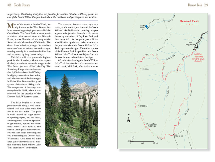
The Deseret Peak hike begins as a very pleasant walk along a well maintained trail that gains only 400 feet in the first mile. The path is well shaded by large groves of
quaking aspen, and the thick, verdant ground cover with patches of geraniums, lupines and other wildflowers only adds to the charm. After just a hundred yards
you will pass a sign indicating that you are entering the Deseret Peak Wilderness Area; then, 0.7 mile later, you will come to a trail junction where the South
Willow Lake Trail branches off to the right.
The presence of several other vague secondary trails near the junction with the South Willow Lake Trail can be confusing. As you approach the junction the main
trail crosses the rocky streambed of Dry Lake Fork and then turns left. At that point you will see a half-hidden sign in the bushes that marks the junction
where the South Willow Lake Trail departs on the right. The return portion of the Deseret Peak loop
hike follows the South Willow Lake Trail back to this junction,
but for now be sure to bear left at the sign.
0.2 mile after leaving the South Willow Lake Trail Junction the
Deseret Peak trail crosses another small creek, Mill Fork, after which it turns south to begin following Mill
Fork Canyon for the next 2.0 miles to the top of the summit ridge. This is the most tiring part of the hike-you must gain 2,300 feet before reaching the summit
ridge-but the unfolding panorama gets more impressive with every step. The trail gradually climbs out of the aspen into a conifer forest, and then it enters a
series of large grassy meadows as it approaches timberline. Along the way you will catch frequent glimpses of the summit on your right.
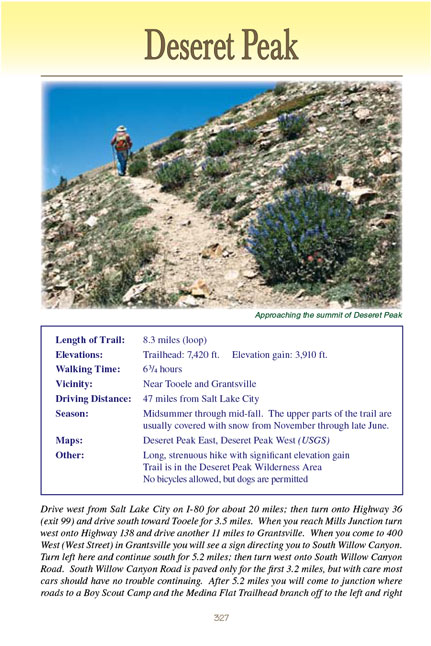
 The last 400 feet are the steepest part of the
Deseret Peak climb; then when you finally reach the summit ridge the scene changes dramatically.
There are no more tall trees here-only a vast, dry expanse of high alpine meadowland. Another small sign marks a junction where trails fan out in three
different directions. Straight ahead will take you into Antelope Canyon, to the left is the Bear Fork Trail, and to the right is the summit trail to Deseret
Peak. For the next 0.9 mile the trail follows the summit ridge in a westerly direction, switchbacking up the last 990 feet of elevation gain, climbing
over a smaller false summit, and continuing on to your goal: the highest point in the Stansbury Range.
The last 400 feet are the steepest part of the
Deseret Peak climb; then when you finally reach the summit ridge the scene changes dramatically.
There are no more tall trees here-only a vast, dry expanse of high alpine meadowland. Another small sign marks a junction where trails fan out in three
different directions. Straight ahead will take you into Antelope Canyon, to the left is the Bear Fork Trail, and to the right is the summit trail to Deseret
Peak. For the next 0.9 mile the trail follows the summit ridge in a westerly direction, switchbacking up the last 990 feet of elevation gain, climbing
over a smaller false summit, and continuing on to your goal: the highest point in the Stansbury Range.
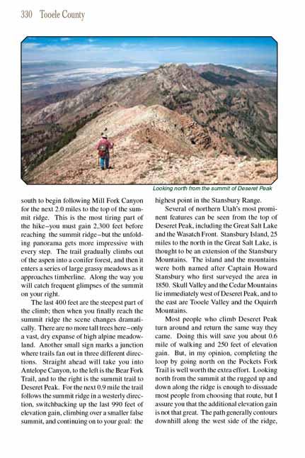
Several of northern Utah’s most prominent features can be seen from the top of Deseret Peak, including the Great Salt Lake and the Wasatch Front. Stansbury
Island, 25 miles to the north in the Great Salt Lake, is thought to be an extension of the Stansbury Mountains. The island and the mountains were both named
after Captain Howard Stansbury who first surveyed the area in 1850. Skull Valley and the Cedar Mountains lie immediately west of Deseret Peak, and to the east
are Tooele Valley and the Oquirrh Mountains.
Most people who climb Deseret Peak turn around and return the same way they came. Doing this will save you about 0.6 mile of walking and 250 feet of elevation
gain. But, in my opinion, completing the loop by going north on the Pockets Fork Trail is well worth the extra effort. Looking north from the summit at the
rugged up and down along the ridge is enough to dissuade most people from choosing that route, but I assure you that the additional elevation gain is not that
great. The path generally contours downhill along the west side of the ridge, and very little additional elevation gain is necessary. The Pockets Fork Trail
is, admittedly, more primitive, but it is nevertheless easy to follow.
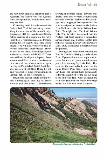
Continuing north from the summit the Pockets Fork Trail follows a steep contour along the west side of the summit ridge, descending 1,170 feet over the next
0.8 mile before arriving at a saddle on the ridge. From there it resumes its descent, dropping another 200 feet over 0.3 mile to the second saddle. You will
know when you have arrived at the second saddle because the Forest Service has placed a small sign there to advise hikers that the trail DOES NOT turn east and
leave the ridge at this point. Some adventurous hikers, however, do choose to turn east and take a steep shortcut, again meeting the Pockets Fork Trail 0.5
mile later after a descent of 1,200 feet. Doing this will save you about 1.3 miles over continuing on the trail, but I do not recommend it.
Beyond the second saddle the trail begins climbing again, realizing 200 feet of elevation gain over the next 0.4 mile before arriving at the third saddle. Here
the Deseret Peak trail finally turns east to begin switchbacking down the slope into the Pockets Fork drainage. After dropping 970 feet you will arrive at another signed
junction where the Pockets Fork Trail meets the South Willow Lake Trail. Turn right here. The South Willow Lake Trail is better maintained than the Pockets
Fork Trail, and also it descends at a more gradual rate. The trail is often used by horses making their way to South Willow Lake, a tiny lake located 1.5 miles
north of the junction.
Turning south on the South Willow Lake Trail for 0.8 mile will bring you to Dry Lake Fork. If you need water you might want to know that the trail passes several
streams just before reaching Dry Lake Fork. This area has the most reliable water on the entire Deseret Peak hike. Upon reaching Dry Lake Fork the trail turns
east again to follow the creek bed for the last 0.6 miles to the Mill Fork Trail. Once you reach the Mill Fork Trail you can retrace your steps the last 0.7
mile back to the trailhead.
Note to web developers: You may copy this material onto your site, but in return please include a link to my home page
www.utahtrails.com. Thank you, David Day (utahdavidday at gmail.com)
Click here to see more
trails near Salt Lake City
© Rincon Publishing Company, all rights reserved
|