Corner Canyon Trails
excerpted from our book
Salt Lake City's Incredible Hiking and Biking Trails
pages 122-126
|
Buy book directly from the author!
Salt Lake City's Incredible Hiking and Biking Trails
- has access info for 73 trailheads
- 73 colorful trail maps
- 325 full color photographs
- loads of hiking tips
|
regularly $19.95
now on sale for only
$9.95
click here
for book orders
|
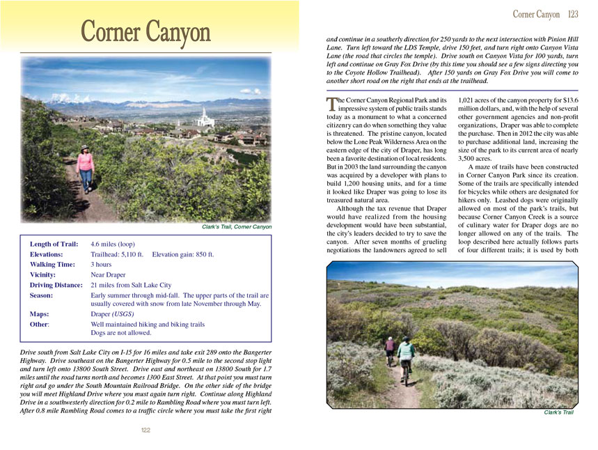
 The Corner Canyon Regional Park and its impressive system of public trails stands today as a monument to what a concerned citizenry
can do when something they value is threatened. The pristine canyon, located below the Lone Peak Wilderness Area on the eastern edge of the city of Draper, has
long been a favorite destination of local residents. But in 2003 the land surrounding
Corner Canyon was acquired by a developer with plans to build 1,200 housing
units, and for a time it looked like Draper was going to lose its treasured natural area.
The Corner Canyon Regional Park and its impressive system of public trails stands today as a monument to what a concerned citizenry
can do when something they value is threatened. The pristine canyon, located below the Lone Peak Wilderness Area on the eastern edge of the city of Draper, has
long been a favorite destination of local residents. But in 2003 the land surrounding
Corner Canyon was acquired by a developer with plans to build 1,200 housing
units, and for a time it looked like Draper was going to lose its treasured natural area.
Although the tax revenue that Draper would have realized from the housing development would have been substantial, the city’s leaders decided to try to save the
canyon. After seven months of grueling negotiations the landowners agreed to sell 1,021 acres of the
Corner Canyon property for $13.6 million dollars, and, with the
help of several other government agencies and non-profit organizations, Draper was able to complete the purchase. Then in 2012 the city was able to purchase
additional land, increasing the size of the park to its current area of nearly 3,500 acres.
A maze of trails have been constructed in Corner Canyon Park since its creation. Some of the trails are specifically intended for bicycles while others are
designated for hikers only. Leashed dogs were originally allowed on most of the park’s trails, but because Corner Canyon Creek is a source of culinary water
for Draper dogs are no longer allowed on any of the trails. The loop described here actually follows parts of four different trails; it is used by both bikers
and hikers.
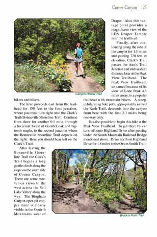
The hike proceeds east from the trailhead for 150 feet to the first junction, where you must turn right onto the Clark’s Trail/Bonneville Shoreline Trail.
Continue from there for another 0.1 mile, through a luxuriant forest of Gambel oak and bigtooth maple, to the second junction where the Bonneville Shoreline
Trail departs on the right. Here you should bear left on the Clark’s Trail.
After leaving the Bonneville Shoreline Trail the Clark’s Trail begins a long gentle climb along the slope on the south side of Corner Canyon. There are some
marvelous views to the west across the Salt Lake Valley along the way. The Bingham Canyon open pit copper mine is clearly visible in the Oquirrh Mountains west
of Draper. Also, this vantage point provides a magnificent view of the LDS Draper Temple near the trailhead.
 Finally, after contouring along the side of
Corner Canyon for 1.3 miles and gaining 720 feet in elevation, Clark’s Trail passes the
Ann’s Trail Junction and ends a short distance later at the Peak View Trailhead. The Peak View Trailhead, so named because of its view of Lone Peak 4.3 miles
away, is a popular trailhead with mountain bikers. A steep, exhilarating bike path, appropriately named the Rush Trail, descends into the canyon from here with
the first 2.3 miles being one-way only.
Finally, after contouring along the side of
Corner Canyon for 1.3 miles and gaining 720 feet in elevation, Clark’s Trail passes the
Ann’s Trail Junction and ends a short distance later at the Peak View Trailhead. The Peak View Trailhead, so named because of its view of Lone Peak 4.3 miles
away, is a popular trailhead with mountain bikers. A steep, exhilarating bike path, appropriately named the Rush Trail, descends into the canyon from here with
the first 2.3 miles being one-way only.
It is also possible to begin the Corner
Canyon hike at the Peak View Trailhead. To get there by car turn left onto Highland Drive after passing under the South Mountain
Railroad Bridge mentioned above. Drive north on Highland Drive for 1.8 miles to the Orson Smith Trailhead and parking area on the right side of the road. There
you will see a high clearance dirt road called the Draper Alpine Road that runs into the mountains in a southeasterly direction. The Peak View Trailhead is 3.4
miles from Highland Drive on this road.
From the Peak View Trailhead you will be descending into Corner Canyon on the Brock’s Point Trail. This trail briefly parallels the Draper Alpine Road in a
northerly direction before turning east to end at a 3-way junction. There you must bear left onto the Canyon Hollow Trail, which you will be following for most
of the remainder of the hike.
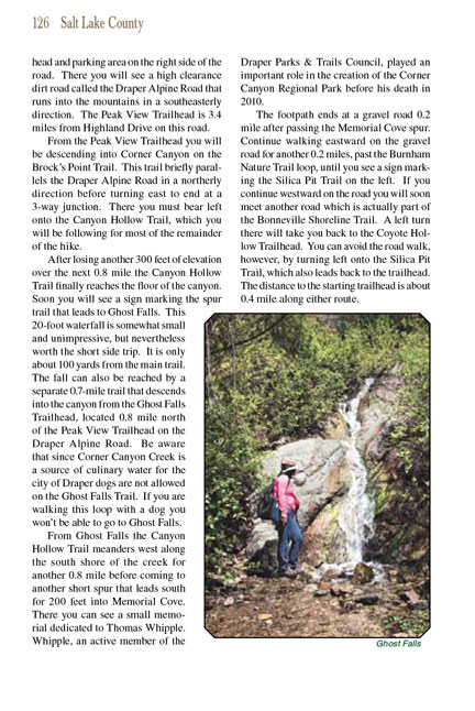
After losing another 300 feet of elevation
over the next 0.8 mile the Canyon Hollow Trail finally reaches the floor of the
canyon. Soon you will see a sign marking the spur trail that leads to Ghost
Falls. This 20-foot waterfall is somewhat small and unimpressive, but
nevertheless worth the short side trip. It is only about 100 yards from the
main trail. The fall can also be reached by a separate 0.7-mile trail that
descends into the canyon from the Ghost Falls Trailhead, located 0.8 mile north
of the Peak View Trailhead on the Draper Alpine Road.
From Ghost Falls the Canyon Hollow Trail meanders west along the south shore of the creek for another 0.8 mile before coming to another short spur that leads south
for 200 feet into Memorial Cove. There you can see a small memorial dedicated to Thomas Whipple. Whipple, an active member of the Draper Parks & Trails Council,
played an important role in the creation of the Corner Canyon Regional Park before his death in 2010.
The footpath ends at a gravel road 0.2 mile after passing the Memorial Cove spur. Continue walking eastward on the gravel road for another 0.2 miles, past the
Burnham Nature Trail loop, until you see a sign marking the Silica Pit Trail on the left. If you continue westward on the road you will soon meet another road
which is actually part of the Bonneville Shoreline Trail. A left turn there will take you back to the Coyote Hollow Trailhead. You can avoid the road walk,
however, by turning left onto the Silica Pit Trail, which also leads back to the trailhead. The distance to the starting trailhead is about 0.4 mile along
either route.
Note to web developers: You may copy this material onto your site, but in return please include a link to my home page
www.utahtrails.com. Thank you, David Day (utahdavidday at gmail.com)
Click here to see more
trails near Salt Lake City
© Rincon Publishing Company, all rights reserved
|