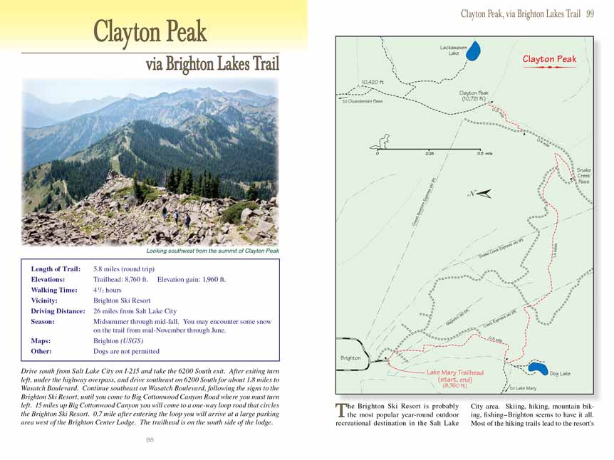
Clayton Peak
via Brighton Lakes Trail
excerpted from our book
Salt Lake City's Incredible Hiking and Biking Trails
pages 98-101
|
Buy book directly from the author!
Salt Lake City's Incredible Hiking and Biking Trails
- has access info for 73 trailheads
- 73 colorful trail maps
- 325 full color photographs
- loads of hiking tips
|
regularly $19.95
now on sale for only
$9.95
click here
for book orders
|
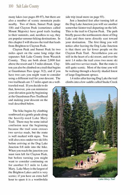
 The Brighton Ski Resort is probably the most popular year-round outdoor recreational destination in the Salt Lake City area. Skiing,
hiking, mountain biking, fishing-Brighton seems to have it all. Most of the hiking trails lead to the resort's many lakes (see pages 89-97), but there are also a
number of scenic mountain peaks nearby. Two of them, Sunset Peak (page 118) and Clayton Peak (sometimes called Mount Majestic) have good trails leading to their
summits, and, needless to say, they are popular summer hiking destinations. In this chapter I will discuss the trail that leads from Brighton to Clayton Peak.
The Brighton Ski Resort is probably the most popular year-round outdoor recreational destination in the Salt Lake City area. Skiing,
hiking, mountain biking, fishing-Brighton seems to have it all. Most of the hiking trails lead to the resort's many lakes (see pages 89-97), but there are also a
number of scenic mountain peaks nearby. Two of them, Sunset Peak (page 118) and Clayton Peak (sometimes called Mount Majestic) have good trails leading to their
summits, and, needless to say, they are popular summer hiking destinations. In this chapter I will discuss the trail that leads from Brighton to Clayton Peak.
Clayton Peak and Sunset Peak lie two miles apart on the same long ridge that separates Salt Lake County from Wasatch County. They are both about 2,000 feet above
the resort and 1.5 miles distant. Clayton Peak can also be climbed on a trail that begins at Guardsman Pass (page 312), and if you have two cars you might want to
consider using a different trail for your descent. The two trailheads are 3.7 miles apart on a well-traveled road. If you decide to do that, however, you can
minimize your elevation gain by beginning at the Guardsman Pass Trailhead and making your descent on the trail described below.
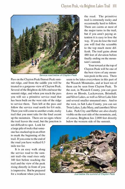
The Claayton Peak hike begins by climbing southward at a gentle grade along the heavily-used Lake Mary Trail. There may be some initial confusion near the beginning because the
trail soon crosses two service roads, but the route is well marked with signs. You will also cross under two ski lifts before arriving at the Dog Lake Junction
0.8 mile into the hike. When you reach the junction you must turn left for Clayton Peak, but before turning you might want to consider continuing on for another
0.3 mile to Lake Mary. Lake Mary is the largest of the Brighton Lakes and it is very scenic; if you have an extra half hour to spare it is a worthwhile side
trip (read more on page 93).
Just a hundred feet after turning left at the Dog Lake Junction you will see another somewhat fainter trail departing on the left. This is the trail to Clayton
Peak. The path briefly passes the northeastern shore of Dog Lake and then turns directly east toward your destination. The first thing you will notice after
leaving the Dog Lake Junction is that there are far fewer people on the Clayton Peak Trail. Nevertheless you are still in the heart of a ski resort, and over
the next 1.4 miles the trail cross two more ski lifts and two service roads. But the route is still quite scenic. Most of the time you will be walking through
a heavily shaded forest of large Engelmann spruce.
1.4 miles after leaving Dog Lake the trail climbs into a low saddle called Snake Creek Pass on the Clayton Peak/Sunset Peak summit ridge, and from the saddle you
will be treated to a gorgeous view of Clayton Peak. Several of the Brighton ski lifts end near the summit ridge, and when you reach the pass you will see a
primitive service road that has been built on the west side of the ridge to service them. Turn left at the pass and follow the service road north for 0.4 mile.
There you will come to another crude, rocky trail that you must take for the final ascent up the mountain. There are no signs where the trail leaves the road,
but the junction is not difficult to spot. Look for a large pile of rocks that someone has stacked up in an effort to mark the beginning of the trail. If you
come to the end of the road you have walked 0.3 mile too far.
It is an easy walk along the service road to the summit trail-the road rises only 140 feet before reaching the trail and the view of the peak rising directly in
front of you is impressive. But be prepared for a workout when you leave the road. The primitive trail
to the Clayton Peak summit is extremely rocky and occasionally hard to follow. There
are cairns at most of the major turns in the trail, but if you aren’t paying attention it is easy to lose the way. If you do lose the trail you will find the
scramble to the top much more difficult. The trail gains about 480 feet of elevation before finally ending on the mountain’s summit.
Your reward at the top of Clayton Peak will be one of the best views of any mountain peak in the area. There seem to be lakes everywhere in this part of the
Wasatch Mountains, and at least ten of them can be seen from Clayton Peak. To the east, in Wasatch County, you can gaze down on Bloods, Lackawaxen, Brimhall,
and Silver Lakes, as well as Silver Lake Islet and several smaller unnamed ones. And to the west, in Salt Lake County, you can see Twin Lakes, Lake Mary, and
(another) Silver Lake. Park City and Heber are also clearly visible on the east side of the mountain, and, of course, Brighton lies 2,000 feet directly below
the western side of the summit.
Note to web developers: You may copy this material onto your site, but in return please include a link to my home page
www.utahtrails.com. Thank you, David Day (utahdavidday
at gmail.com)
Click here to see more
trails near Salt Lake City
© Rincon Publishing Company, all rights reserved
|