City Creek Canyon
excerpted from our book
Salt Lake City's Incredible Hiking and Biking Trails
pages 127-131
|
Buy book directly from the author!
Salt Lake City's Incredible Hiking and Biking Trails
- has access info for 73 trailheads
- 73 colorful trail maps
- 325 full color photographs
- loads of hiking tips
|
regularly $19.95
now on sale for only
$9.95
click here
for book orders
|
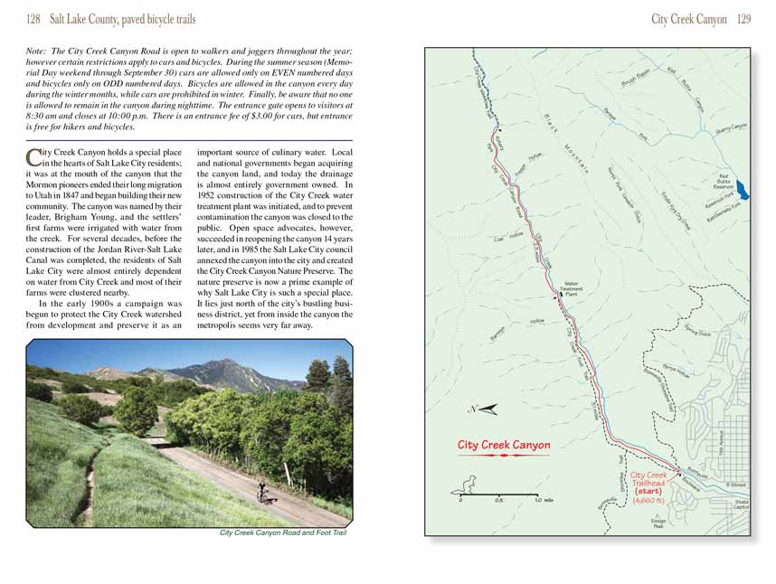
 City Creek Canyon holds a special place in the hearts of Salt Lake City residents; it was at the mouth of the canyon that the Mormon
pioneers ended their long migration to Utah in 1847 and began building their new community. The canyon was named by their leader, Brigham Young, and the settlers’
first farms were irrigated with water from the creek. For several decades, before the construction of the Jordan River-Salt Lake Canal was completed, the
residents of Salt Lake City were almost entirely dependent on water from City Creek and most of their farms were clustered nearby.
City Creek Canyon holds a special place in the hearts of Salt Lake City residents; it was at the mouth of the canyon that the Mormon
pioneers ended their long migration to Utah in 1847 and began building their new community. The canyon was named by their leader, Brigham Young, and the settlers’
first farms were irrigated with water from the creek. For several decades, before the construction of the Jordan River-Salt Lake Canal was completed, the
residents of Salt Lake City were almost entirely dependent on water from City Creek and most of their farms were clustered nearby.
In the early 1900s a campaign was begun to protect the City Creek watershed from development and preserve it as an important source of culinary water. Local and
national governments began acquiring the canyon land, and today the drainage is almost entirely government owned. In 1952 construction of the City Creek water
treatment plant was initiated, and to prevent contamination the canyon was closed to the public. Open space advocates, however, succeeded in reopening the
canyon 14 years later, and in 1985 the Salt Lake City council annexed the canyon into the city and created the City Creek Canyon Nature Preserve. The nature
preserve is now a prime example of why Salt Lake City is such a special place. It lies just north of the city’s bustling business district, yet from inside
the canyon the metropolis seems very far away.
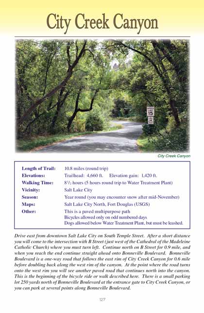
Most people prefer to walk or bike the City Creek Canyon Road on odd numbered days during the summer when cars are not allowed, and that is the choice I will
describe here. Hikers and joggers however may be interested to know that there is also an unpaved foot trail through most of the canyon that runs above the
northwest side of the road. The City Creek Foot Trail begins on the west side of the junction where the City Creek Canyon Road departs from Bonneville Boulevard.
That is also the point where the Bonneville Shoreline Trail crosses City Creek Canyon Road, and for a short distance the two trails follow the same route above
the northwest side of the canyon. After 0.7 mile, however, the Bonneville Trail splits off from the City Creek Trail and climbs west into the foothills above
the canyon.
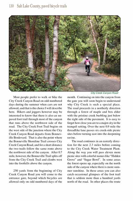
 250 yards from the beginning of City Creek Canyon Road you will come to the entrance gate, beyond which bicycles are allowed only
on odd numbered days of the month. Continuing on into the canyon from the gate you will soon begin to understand why City Creek is such a special place. The
road proceeds in a northerly direction through a forest of maple and box elder with the pristine creek burbling just below the right side of the pavement. It
is easy to forget how close you are to a major city in the tranquil setting. Over the next 0.9 mile the threadlike lane passes six creek-side picnic sites
before turning east into the deepening ravine.
250 yards from the beginning of City Creek Canyon Road you will come to the entrance gate, beyond which bicycles are allowed only
on odd numbered days of the month. Continuing on into the canyon from the gate you will soon begin to understand why City Creek is such a special place. The
road proceeds in a northerly direction through a forest of maple and box elder with the pristine creek burbling just below the right side of the pavement. It
is easy to forget how close you are to a major city in the tranquil setting. Over the next 0.9 mile the threadlike lane passes six creek-side picnic sites
before turning east into the deepening ravine.
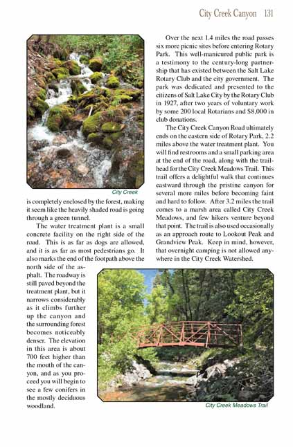
The road continues in an easterly direction for the next 2.3 miles before coming to the City Creek Water Treatment Plant. Along the way you will pass eleven
more picnic sites with colorful names like “Hidden Grove” and “Sugar Bowl”. In some areas the forest opens up, especially on the north side of the canyon where
there is more summer sunshine. In these areas you can also catch occasional glimpses of the foot trail that is seldom more than a hundred yards north of the
road. In other places the route is completely enclosed by the forest, making it seem like the heavily shaded road is going through a green tunnel.
The City Creek water treatment plant is a small concrete facility on the right side of the road. This is as far as dogs are allowed, and it is as far as most pedestrians go.
It also marks the end of the footpath above the north side of the asphalt. The roadway is still paved beyond the treatment plant, but it narrows considerably as
it climbs further up City Creek Canyon and the surrounding forest becomes noticeably denser. The elevation in this area is about 700 feet higher than the mouth of the
canyon, and as you proceed you will begin to see a few conifers in the mostly deciduous woodland.
Over the next 1.4 miles the City Creek Canyon road passes six more picnic sites before entering Rotary Park. This well-manicured public park is a testimony to the century-long
partnership that has existed between the Salt Lake Rotary Club and the city government. The park was dedicated and presented to the citizens of Salt Lake City
by the Rotary Club in 1927, after two years of voluntary work by some 200 local Rotarians and $8,000 in club donations.
The City Creek Canyon Road ultimately ends on the eastern side of Rotary Park, 2.2 miles above the water treatment plant. You will find restrooms and a small
parking area at the end of the road, along with the trailhead for the City Creek Meadows Trail. This trail offers a delightful walk that continues eastward
through the pristine canyon for several more miles before becoming faint and hard to follow. After 3.2 miles the trail comes to a marsh area called City Creek
Meadows, and few hikers venture beyond that point. The trail is also used occasionally as an approach route to Lookout Peak and Grandview Peak. Keep in mind,
however, that overnight camping is not allowed anywhere in the City Creek Watershed.
Note to web developers: You may copy this material onto your site, but in return please include a link to my home page
www.utahtrails.com. Thank you, David Day (utahdavidday at gmail.com)
Click here to see more
trails near Salt Lake City
© Rincon Publishing Company, all rights reserved
|