Box Elder Peak
excerpted from our book
Salt Lake City's Incredible Hiking and Biking Trails
pages 170-174
|
Buy book directly from the author!
Salt Lake City's Incredible Hiking and Biking Trails
- has access info for 73 trailheads
- 73 colorful trail maps
- 325 full color photographs
- loads of hiking tips
|
regularly $19.95
now on sale for only
$9.95
click here
for book orders
|
 Box Elder Peak is one of those hikes that you will probably do only once, but you will also remember it fondly for years
afterward. It is not an easy hike; over 4,000 feet of elevation gain is required and there is no developed trail for the last 1,700 feet of the climb.
It is a long, grueling hike, but when you reach the summit the breathtaking views will almost make you forget how tired you are.
Box Elder Peak is one of those hikes that you will probably do only once, but you will also remember it fondly for years
afterward. It is not an easy hike; over 4,000 feet of elevation gain is required and there is no developed trail for the last 1,700 feet of the climb.
It is a long, grueling hike, but when you reach the summit the breathtaking views will almost make you forget how tired you are.
Box Elder Peak is completely surrounded by Forest Service trails; two of them depart from Granite Flat and two more leave from the Dry Creek Trailhead in Alpine,
so hikers have a choice of four different approaches to the mountain. The final off-trail ascent to the summit is usually made up one of two ridges: one
on the north side of the peak and one on the south side. Regardless of which route you choose, however, the final ascent must be made without the benefit
of a developed trail.
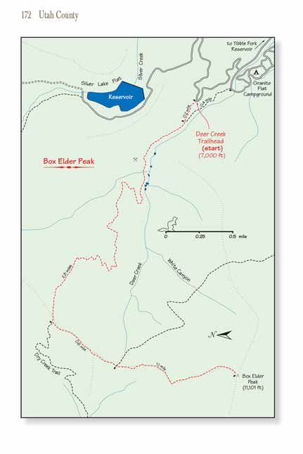
The route I will describe here begins at Granite Flat and uses the mountain’s north ridge for the final ascent to the summit
of Box Elder Peak. This is the easiest way to
the top and also the most popular route. The trailhead at Granite Flat is 1,300 higher than the Dry Creek Trailhead in Alpine, so less elevation gain is
required from Granite Flat. Furthermore, the north ridge of Box Elder Peak is not quite as steep as the south ridge, and since that route is more frequently used a crude
hiker-made trail is beginning to form along the north ridge. The climb up
Box Elder Peak from the north is still very steep (1,700 feet of elevation gain in only 1.1
miles), but the presence of the primitive trail does make it a little easier that it would otherwise be.
The Box Elder Peak trail from the upper Deer Creek Trailhead begins as a very pleasant walk through a well shaded grove of bigtooth maple. After 0.2 mile you will come
to a junction where the path is joined by the trail coming up from the lower Deer Creek Trailhead in the campground. Continuing past the junction the
grade picks up slightly as you climb above the north side of Deer Creek. After about 15 minutes the path crosses a small unnamed stream that flows south
into Deer Creek. This stream is the only reliable water you will encounter on the hike.
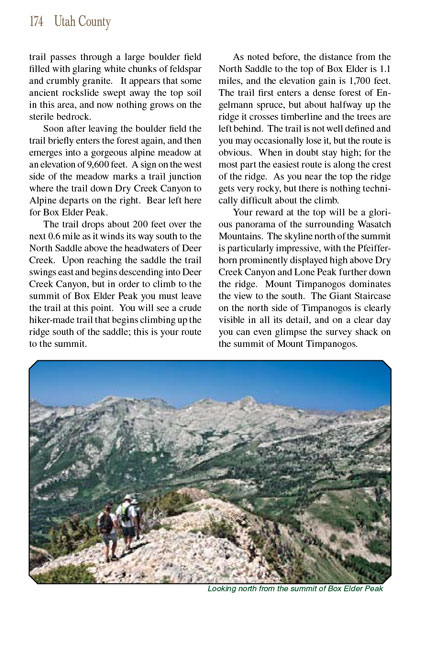 The trail is about a hundred feet above Deer Creek in this area, and the creek flows through a swampy area that is filled
with a half dozen beaver ponds. As you walk you will see several short spur trails that depart from the main path to viewpoints above the ponds. Then,
shortly after passing the last pond the Box Elder Peak trail briefly doubles back to the east as it begins climbing higher up the slope north of Deer Creek Canyon.
The trail is about a hundred feet above Deer Creek in this area, and the creek flows through a swampy area that is filled
with a half dozen beaver ponds. As you walk you will see several short spur trails that depart from the main path to viewpoints above the ponds. Then,
shortly after passing the last pond the Box Elder Peak trail briefly doubles back to the east as it begins climbing higher up the slope north of Deer Creek Canyon.
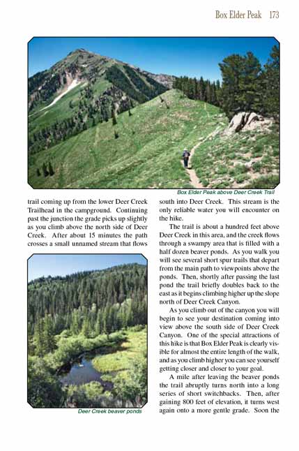
As you climb out of the canyon you will begin to see your destination coming into view above the south side of Deer Creek Canyon. One of the special attractions
of this hike is that Box Elder Peak is clearly visible for almost the entire length of the walk, and as you climb higher you can see yourself getting closer and
closer to your goal.
A mile after leaving the beaver ponds the trail abruptly turns north into a long series of short switchbacks. Then, after gaining 800 feet of elevation, it
turns west again onto a more gentle grade. Soon the Box Elder Peak trail passes through a large boulder field filled with glaring white chunks of feldspar and crumbly
granite. It appears that some ancient rockslide swept away the top soil in this area, and now nothing grows on the sterile bedrock.
After leaving the boulder field the Box Elder Peak trail briefly enters the forest again, and then emerges into a gorgeous alpine meadow at an elevation of 9,600 feet.
A sign on the west side of the meadow marks a trail junction where the trail down Dry Creek Canyon to Alpine departs on the right. Bear left here for Box
Elder Peak.
The trail drops about 200 feet over the next 0.6 mile as it winds its way south to the North Saddle above the headwaters of Deer Creek. Upon reaching the
saddle the trail swings east and begins descending into Deer Creek Canyon, but in order to climb to the summit of Box Elder Peak you must leave the trail
at this point. You will see a crude hiker-made trail that begins climbing up the ridge south of the saddle; this is your route to the summit.
As noted before, the distance from the North Saddle to the top of Box Elder
Peak is 1.1 miles, and the elevation gain is 1,700 feet. The trail first enters a
dense forest of Engelmann spruce, but about halfway up the ridge it crosses timberline and the trees are left behind. The trail is not well defined and
you may occasionally lose it, but the route is obvious. When in doubt stay high; for the most part the easiest route is along the crest of the ridge.
As you near the top the ridge gets very rocky, but there is nothing technically difficult about the climb.
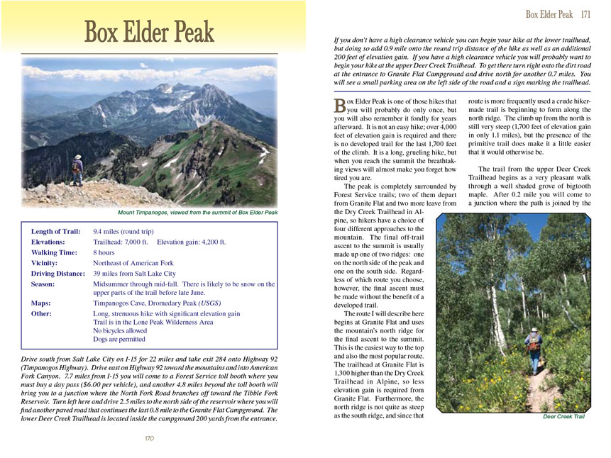
Your reward at the top of Box Elder Peak will be a glorious panorama of the surrounding Wasatch Mountains. The skyline north of the summit is particularly impressive, with
the Pfeifferhorn prominently displayed high above Dry Creek Canyon and Lone Peak further down the ridge. Mount Timpanogos dominates the view to the south.
The Giant Staircase on the north side of Timpanogos is clearly visible in all its detail, and on a clear day you can even glimpse the survey shack on the
summit of Mount Timpanogos.
Note to web developers: You may copy this material onto your site, but in return please include a link to my home page
www.utahtrails.com. Thank you, David Day (utahdavidday at gmail.com)
Click here to see more
trails near Salt Lake City
© Rincon Publishing Company, all rights reserved
|