Adams Canyon Trail
excerpted from our book
Salt Lake City's Incredible Hiking and Biking Trails
pages 264-266
|
Buy book directly from the author!
Salt Lake City's Incredible Hiking and Biking Trails
- has access info for 73 trailheads
- 73 colorful trail maps
- 325 full color photographs
- loads of hiking tips
|
regularly $19.95
now on sale for only
$9.95
click here
for book orders
|
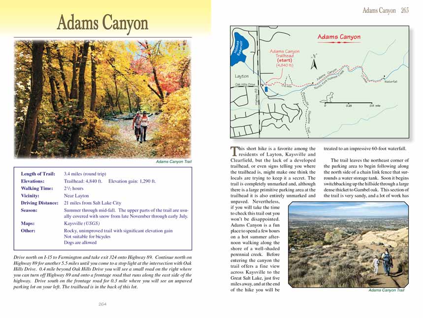
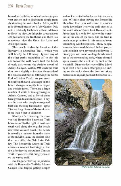
This short hike into Adams Canyon is a favorite among the residents of Layton, Kaysville and Clearfield, but the lack of a developed trailhead,
or even signs telling you where the trailhead is, might make one think the locals are trying to keep it a secret. The
Adams Canyon Trail is completely unmarked and,
although there is a large primitive parking area at the trailhead it is also entirely unmarked and unpaved. Nevertheless, if you will take the time to
check out the Adams Canyon Trail out you won’t be disappointed. Adams Canyon is a fun place to spend a few hours on a hot summer afternoon walking along the shore of a
well-shaded perennial creek. Before entering the canyon the trail offers a fine view across Kaysville to the Great Salt Lake, just five miles away, and
at the end of the hike you will be treated to an impressive 60-foot waterfall.
The Adams Canyon Trail leaves the northeast corner of the parking area to begin following along the north side of a chain link fence that surrounds a water storage tank.
Soon it begins switchbacking up the hillside through a large dense thicket to Gambel oak. This section of the trail is very sandy, and a lot of work has
been done building wooden barriers to prevent erosion and to discourage people from shortcutting the switchbacks. After just 0.3 mile the
Adams Canyon Trail breaks out
of the Gambel Oak onto a relatively flat bench with no tall trees to block the view. At this point you are about 350 feet above the trailhead, and there
is a marvelous view the Great Salt Lake and Antelope Island.
This bench is also the location of the Bonneville Shoreline Trail, which you will briefly be following. Ignore any of the other paths branching off to the
left and follow the well beaten trail that heads directly east toward the obvious mouth of Adams Canyon. Within 250 yards the
Adams Canyon Trail dips down slightly as
it enters the mouth of the canyon and begins following the North Fork of Holms Creek. As you enter the canyon the arid landscape on the bench changes
abruptly to a maple and conifer forest. There are a large number of white fir trees growing in Adams Canyon, and a few of them have grown to enormous size.
They are the trees with deeply corrugated bark and the long flat needles-up to 2 inches long. Some of the trunks are more than 3 feet in diameter.
Shortly after entering the canyon the Bonneville Shoreline Trail branches off to the right to continue southward along the long flat bench above the Wasatch
Front. This bench is actually a remnant from the shore of Bonneville Lake, the ancient lake that once filled the Salt Lake Valley. The Bonneville Shoreline
Trail crosses a wooden footbridge a few feet after leaving the Adams Canyon Trail; if you cross that bridge you are on the wrong trail.
Not long after leaving the junction with the Bonneville Trail the Adams Canyon Trail begins getting steeper and rockier as it climbs deeper into the canyon.
0.7 mile after leaving the Bonneville Shoreline Trail you will come to another crude footbridge where the trail crosses to the south side of North Fork Holms
Creek. From there it is only 0.4 mile to the waterfall at the end of the trail, but the trail is much more primitive in this area and some scrambling will
be required. Many people, however, have used this trail before you, so you shouldn’t have any trouble following it. Finally you will come to a large bowl
carved out of the surrounding rock, where the Adams Canyon Trail again crosses the creek at the foot of the waterfall. On most days you will be joined by at least a
half dozen other people climbing on the rocks above the bowl or taking pictures and enjoying a snack below the fall.
Note to web developers: You may copy this material onto your site, but in return please include a link to my home page
www.utahtrails.com. Thank you, David Day (utahdavidday at gmail.com)
Click here to see more
trails near Salt Lake City
© Rincon Publishing Company, all rights reserved
|