With over 350 miles of trails to choose from Rocky
Mountain National Park is truly a hiker’s paradise, but in my opinion
the greatest concentration of beautiful alpine scenery lies in the
vicinity of Bear Lake. Four trails leave Bear Lake in different
directions to explore the eastern slopes of the Continental Divide. The
hike described here uses two of these trails to complete a loop south of
the lake with side trips into three glacial canyons on the edge of the
Divide. The route passes by no fewer than seven icy lakes, fed by the
melting snow in the upper canyons. Five of the lakes lie above 10,000
feet, surrounded by a few stunted Engelmann spruce and subalpine fir
that somehow manage to survive in an environment that buries them in
snow for six months of every year. It is a harsh, unforgiving
environment, but it also has a stark beauty that is hard to forget.
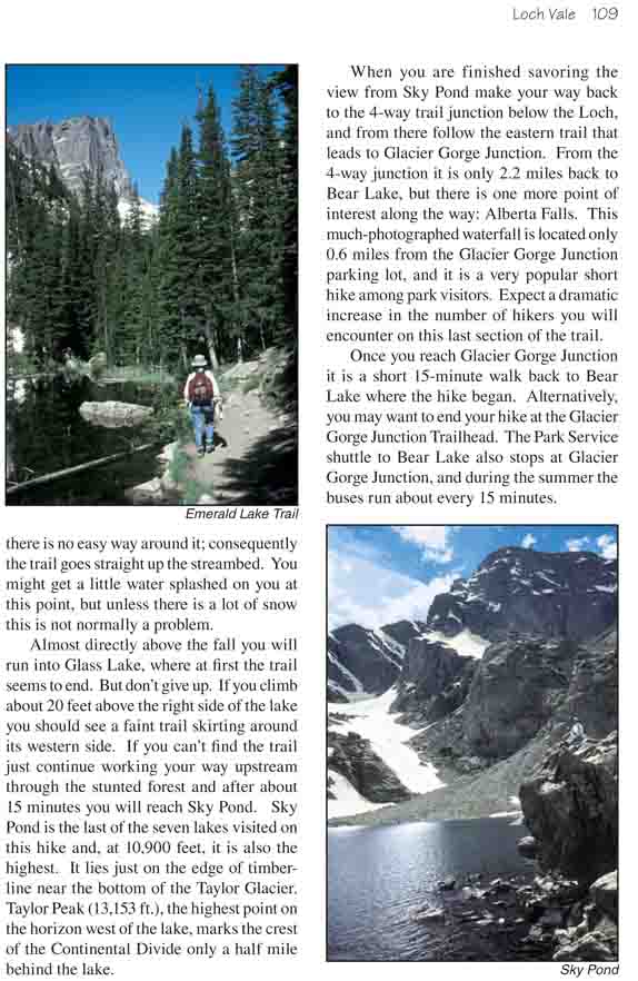
To begin take the trail on the south side of Bear
Lake near the ranger station, and follow the signs to Dream and Emerald
Lakes. The trail immediately starts gaining altitude as it winds through
a dense forest of lodgepole pine and Engelmann spruce, but the assent is
gradual. Over the next 1.8 miles to Emerald Lake you will gain a total
of only 605 feet. There are usually many people along this section of
the trail, but beyond the first mile the crowd thins considerably.
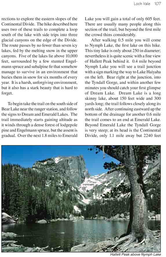
After walking 0.5 mile you will come to Nymph Lake,
the first lake on this hike. This tiny lake is only about 250 in
diameter; nevertheless it is quite scenic with a fine view of Hallett Peak behind it.
0.4 mile beyond Nymph Lake you will see a trail junction with a sign marking
the way to Lake Haiyaha on the left. Bear right at the junction, into the
Tyndall Gorge, and within another few minutes you should catch your first
glimpse of Dream Lake. Dream Lake is a long skinny lake, about 150 feet wide
and 300 yards long; the trail follows closely along its north side. After
continuing eastward up the bottom of the drainage for another 0.6 mile the
trail comes to an end at Emerald Lake. Beyond Emerald Lake the Tyndall Gorge
is very steep; at its head is the Continental Divide, only 1.1 mile away but
2240 feet higher in elevation. Looking up the gorge you can see Flattop
Mountain (12,324 ft.) on the right, Hallett Peak (12,713 ft.) on the left,
and the Tyndall Glacier reaching downward between the two. It is an
impressive sight.
From Emerald Lake you must backtrack to the trail
junction below Dream Lake and turn south. After walking 0.9 miles on this
trail you will come to another junction where a short spur trail leads into
Chaos Canyon for 0.2 miles to Lake Haiyaha. This junction, like all of the
trail junctions in this area, is well marked with signs, so you shouldn’t
have any trouble finding your way. Lake Haiyaha is just slightly larger than
Emerald Lake. Roughly circular in shape and about 250 yards in diameter, it
is located at the foot of a huge pile of granite boulders, obviously
deposited by the ancient glacier that once filled Chaos Canyon. Again there
is a permanent snowfield at the top of the canyon, but the view is not quite
as dramatic as Tyndall Gorge.
Back on the main trail below Lake Haiyaha, you must
continue south for another 1.0 mile to the next trail junction at the mouth
of Loch Vale. This is a major junction with four trails branching off from
it, but again the trail signs will tell you which way to go. You should bear
right at the junction and proceed in an easterly direction into Loch Vale.
This is the longest and, in my opinion, the most interesting glacial valley
you will explore on this hike. You must walk 2.3 miles from the junction to
reach the end of the trail at Sky Pond, but the walk through the sub-alpine
valley is well worth the time and energy spent.
After you have walked about 20 minutes from the junction
you will come upon the Loch, a 450-yard-long lake that is the largest of the
seven lakes encountered on this hike. From the Loch the trail meanders up
the valley along the north side of a small stream called Icy Brook before
reaching a minor obstacle: Timberline Falls. Timberline is not really a
waterfall, but rather a cascade. It lies directly in the center of the
canyon, and there is no easy way around it; consequently the trail goes
straight up the streambed. You might get a little water splashed on you at
this point, but unless there is a lot of snow this is not normally a
problem.
Almost directly above the fall you will run into Glass
Lake, where at first the trail seems to end. But don’t give up. If you climb
about 20 feet above the right side of the lake you should see a faint trail
skirting around its western side. If you can’t find the trail just continue
working your way upstream through the stunted forest and after about 15
minutes you will reach Sky Pond. Sky Pond is the last of the seven lakes
visited on this hike and, at 10,900 feet, it is also the highest. It lies
just on the edge of timberline near the bottom of the Taylor Glacier. Taylor
Peak (13,153 ft.), the highest point on the horizon west of the lake, marks
the crest of the Continental Divide only a half mile behind the lake.
When you are finished savoring the view from Sky Pond
make your way back to the 4-way trail junction below the Loch, and from
there follow the eastern trail that leads to Glacier Gorge Junction. From
the 4-way junction it is only 2.2 miles back to Bear Lake, but there is one
more point of interest along the way: Alberta Falls. This much-photographed
waterfall is located only 0.6 miles from the Glacier Gorge Junction parking
lot, and it is a very popular short hike among park visitors. Expect a
dramatic increase in the number of hikers you will encounter on this last
section of the trail.
Once you reach Glacier Gorge Junction it is a short
15-minute walk back to Bear Lake where the hike began. Alternatively, you
may want to end your hike at the Glacier Gorge Junction Trailhead. The Park
Service shuttle to Bear Lake also stops at Glacier Gorge Junction, and
during the summer the buses run about every 15 minutes.