As the name suggests, Ice Lake Basin lies high above
timberline in a corner of the San Juan Mountains known for its long winters
and short summers. Ice Lake and its neighboring lakes are frozen for at
least eight months of the year, and the valley they occupy is bordered by
several snowfields that never completely melt. There are four named lakes
within the basin and five or six unnamed ones, all remnants of the glaciers
that long ago created the bowl-shaped valley. The basin is a textbook
example of an alpine depression that was gouged out of the mountains by a
long succession of glaciers that have periodically resided here over the
past 900,000 years.
To the west the basin is bordered by a long
crescent-shaped ridge of thirteen-thousand-foot peaks that were probably
never completely covered with ice, but below them accumulations of ice and
snow occasionally collected to produce intermittent glaciers that were, at
times, over a thousand feet thick. Propelled by their own weight, the
glaciers slowly moved eastward down the slopes of the mountain, and as they
moved they left a bed of unseen destruction in their wake. Pushing and
shoving, gouging and scraping like enormous earth-moving machines, the huge
masses of ice changed the landscape completely. Today the glaciers are gone,
but their legacy remains. All of the cirques and tarns of Ice Lake Basin, as
well as the beautiful U-shaped South Mineral Valley below were sculpted by
the glaciers of previous ice ages.
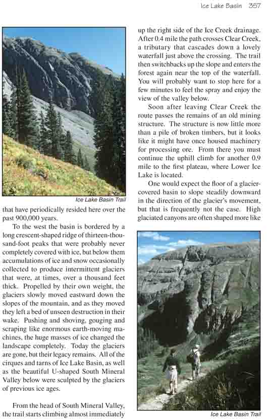
From the head of South Mineral Valley, the trail starts
climbing almost immediately up the right side of the Ice Creek drainage.
After 0.4 mile the path crosses Clear Creek, a tributary that cascades down
a lovely waterfall just above the crossing. The trail then switchbacks up
the slope and enters the forest again near the top of the waterfall. You
will probably want to stop here for a few minutes to feel the spray and
enjoy the view of the valley below.
Soon after leaving Clear Creek the route passes the
remains of an old mining structure. The structure is now little more than a
pile of broken timbers, but it looks like it might have once housed
machinery for processing ore. From there you must continue the uphill climb
for another 0.9 mile to the first plateau, where Lower Ice Lake is located.
One would expect the floor of a glacier-covered basin to
slope steadily downward in the direction of the glacier’s movement, but that
is frequently not the case. High glaciated canyons are often shaped more
like stair steps, with steep sections followed by plateaus. This
irregularity may have resulted from the different hardnesses of the rock
layers. Or it might be the result of the fact that the glaciation was not a
single event, but rather occurred in many episodes. The last Ice Age lasted
some 100,000 years, and before that there were many earlier ones.
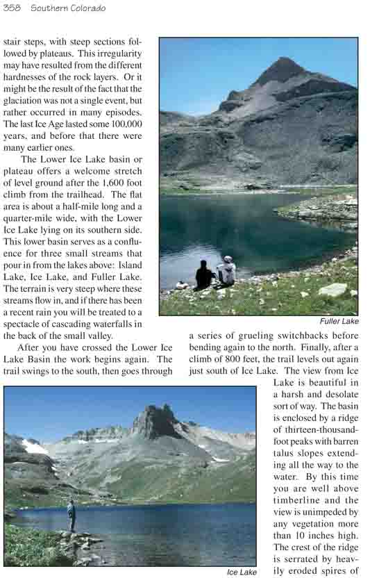
The Lower Ice Lake basin or plateau offers a welcome
stretch of level ground after the 1,600 foot climb from the trailhead. The
flat area is about a half-mile long and a quarter-mile wide, with the Lower
Ice Lake lying on its southern side. This lower basin serves as a confluence
for three small streams that pour in from the lakes above: Island Lake, Ice
Lake, and Fuller Lake. The terrain is very steep where these streams flow
in, and if there has been a recent rain you will be treated to a spectacle
of cascading waterfalls in the back of the small valley.
After you have crossed the Lower Ice Lake Basin the work
begins again. The trail swings to the south, then goes through a series of
grueling switchbacks before bending again to the north. Finally, after a
climb of 800 feet, the trail levels out again just south of Ice Lake. The
view from Ice Lake is beautiful in a harsh and desolate sort of way. The
basin is enclosed by a ridge of thirteen-thousand-foot peaks with barren
talus slopes extending all the way to the water. By this time you are well
above timberline and the view is unimpeded by any vegetation more than 10
inches high. The crest of the ridge is serrated by heavily eroded spires of
volcanic rock, but the peaks don’t really look that high from this vantage
point; they are only a thousand feet above the bottom of the basin. The
terrain is high enough to foster permanent snowfields, and the lakes are
clear and blue.
From Ice Lake the trail turns south and climbs another
330 feet to Fuller Lake, the highest and southernmost lake in the basin. The
view looking back on Ice Lake with U.S. Grant Peak (13,767 ft.) in the
background is gorgeous, but Fuller Lake itself is not as pretty as Ice Lake.
The serenity is marred by the presence of a broken-down miner’s cabin of
recent vintage on the shore of the lake. Bits of aluminum siding are
scattered about (in the lake as well as on the ground), and an old
helicopter rotor blade forms a bench in front of the cabin.
In my opinion the prettiest and most interesting lake in
Ice Lake Basin is Island Lake. To get there you must return to Ice Lake and
look up the slope above the northeast corner of the lake. You should see a
faint trail angling up the slope near the bottom of an old mine tailing. If
you walk down the drainage for a few hundred feet below Ice Lake you will
find the beginning of this trail near an easy spot to cross the creek. The
trail continues up past the mine tailing for a short way, and then doubles
back into a higher, hidden basin containing Island Lake.
Island Lake lies in the bottom of a steep sided bowl that
looks for all the world like an extinct volcanic crater. Geologists assure
us that the bowl was formed by glaciation, but a part of me remains
unconvinced. Even the small island in the center suggests otherwise.
Many a swimmer has undoubtedly felt challenged by the small, rocky island
that gives Island Lake its name. The island is situated only a hundred feet
from the southern shore, but the water, even in late summer, is very cold.
In the words of local writer, Sven Brunso, the lake "can provide a
refreshing swim if you happen to have packed in your defibrillator to
restart your heart after plunging into the 35-degree slurpee."