The unusual flat-topped mountains of the Flat Tops
Wilderness Area provide a unique opportunity to hike in an alpine-tundra
ecological environment without a great deal of tiring elevation gain. Most
high-altitude hikes in Colorado are in very rugged terrain with little level
ground. But in the Flat Tops once you have climbed above timberline there is
very little up and down on the trails. A hike on the top of the Flat Tops is
more of a pleasant stroll through fields of high alpine wildflowers, with
panoramas of a vast treeless tundra, more like what one would expect to find
in northern Canada.
The reason that the mountains are so flat can be traced
to a period of prolonged volcanic activity that occurred in Colorado about
35 million years ago. During that time the underlying sedimentary rock was
covered with a thick layer of hard basaltic lava. Later, when the land began
to rise and erode the basalt acted like a capstone, protecting the softer
rock beneath. Today we see flat topped mountains in the places that were
covered by the ancient lava flows, while the surrounding valleys and canyons
are sculpted from the softer underlying sedimentary layers.
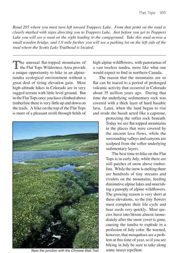
The best time to hike on the Flat Tops is in early July,
while there are still patches of snow above timberline. While the snow is
melting there are hundreds of tiny streams and rivulets on the mountains,
feeding diminutive alpine lakes and nourishing a panoply of alpine
wildflowers. The growing season is very short at these elevations, so the
tiny flowers must complete their life cycle and bear seeds very quickly.
Most species burst into bloom almost immediately after the snow cover is
gone, causing the tundra to explode in a profusion of July color. Be warned,
however, that mosquitoes are a problem at this time of year, so if you are
hiking in July be sure to take along some insect repellent.
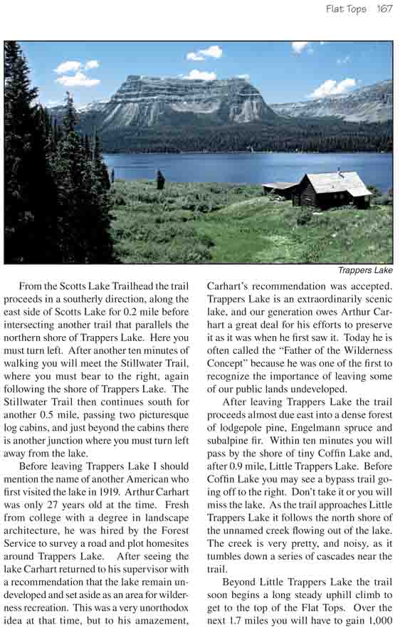
From the Scotts Lake Trailhead the trail proceeds in a
southerly direction, along the east side of Scotts Lake for 0.2 mile before
intersecting another trail that parallels the northern shore of Trappers
Lake. Here you must turn left. After another ten minutes of walking you will
meet the Stillwater Trail, where you must bear to the right, again following
the shore of Trappers Lake. The Stillwater Trail then continues south for
another 0.5 mile, passing two picturesque log cabins, and just beyond the
cabins there is another junction where you must turn left away from the
lake.
Before leaving Trappers Lake I should mention the name of
another American who first visited the lake in 1919. Arthur Carhart was only
27 years old at the time. Fresh from college with a degree in landscape
architecture, he was hired by the Forest Service to survey a road and plot
homesites around Trappers Lake. After seeing the lake Carhart returned to
his supervisor with a recommendation that the lake remain undeveloped and
set aside as an area for wilderness recreation. This was a very unorthodox
idea at that time, but to his amazement, Carhart’s recommendation was
accepted. Trappers Lake is an extraordinarily scenic lake, and our
generation owes Arthur Carhart a great deal for his efforts to preserve it
as it was when he first saw it. Today he is often called the "Father of the
Wilderness Concept" because he was one of the first to recognize the
importance of leaving some of our public lands undeveloped.
After leaving Trappers Lake the trail proceeds almost due
east into a dense forest of lodgepole pine, Engelmann spruce and subalpine
fir. Within ten minutes you will pass by the shore of tiny Coffin Lake and,
after 0.9 mile, Little Trappers Lake. Before Coffin Lake you may see a
bypass trail going off to the right. Don’t take it or you will miss the
lake. As the trail approaches Little Trappers Lake it follows the north
shore of the unnamed creek flowing out of the lake. The creek is very
pretty, and noisy, as it tumbles down a series of cascades near the trail.
Beyond Little Trappers Lake the trail soon begins a long
steady uphill climb to get to the top of the Flat Tops. Over the next 1.7
miles you will have to gain 1,000 feet of elevation before the trail levels
out again. But the climb is an interesting one. Watch the size of the trees
diminish as you gain altitude. The Engelmann spruce go from over 100 feet to
five feet high before they disappear completely at about 11,000 feet.
Once you reach the top of the Flat Tops the trees are
replaced by a tundra of flowers and grasses. Thousands on individual dots of
color litter the ground. Individually, each flower is a masterpiece of
design. Some are shaped like little yellow teacups, some look like miniature
purple elephant heads, complete with ears and trunks, and some look so much
like bells you can almost hear them chiming in the wind. Together the alpine
flowers produce delightful blends of blue, purple, white, green, and
especially yellow across the rolling highland. Elsewhere, much of the Flat
Tops tundra has been destroyed by grazing sheep, but for some reason the
land along this trail has been exempted from the grazing. It remains
pristine.
3.9 miles after leaving Trappers Lake the trail arrives
at a junction where an old weathered sign marks the beginning of the Chinese
Wall Trail. Continue straight ahead at this point, staying on the Stillwater
Trail. Then, 0.3 mile later, you will see yet another sign marking the
beginning of the West Mountain Trail on your right. Again, continue
straight.
The West Mountain Trail marks the highest point on this
hike (11,412 feet), and a short way beyond that point the Stillwater Trail
begins its descent to Stillwater Reservoir. The trail makes the descent in
four distinct stages. First it drops about 200 feet into a small basin on
the eastern side of the mountain. Then after a brief respite it drops
another 200 feet into a slightly larger and flatter basin. Next it looses
another 400 feet of elevation before leveling out once again on the shore of
Mosquito Lake. Finally, 0.2 mile beyond Mosquito Lake, the trail begins its
final 300 feet of gradual descent to the Stillwater Trailhead. The last four
miles of the trail follow the western side of Stillwater Creek and
Stillwater Reservoir.