There are two ways to hike to the Tuhare Lakes: you can
walk south from the Half Moon/Fall Creek Trailhead (nearer Minturn) for a
distance of 5.4 miles, or you can walk north from the Hunky Dory Trailhead
for a distance of 5.2 miles. It is much easier to drive to the Half
Moon/Fall Creek Trailhead, so most people begin the hike from there, but in
my opinion the trail from Hunky Dory is much more interesting than the
northern route. For that reason I will describe the southern trail. The hike
from the Hunky Dory Trailhead takes you past the Seven Sisters Lakes and
over Fall Creek Pass before dropping down to the Tuhare Lakes Trail.
Furthermore, Holy Cross City is just a 15-minute walk from the Hunky Dory
Trailhead. You might want to take a side trip to see that historic ghost
town before beginning this hike. (See page 227.)
In order to reach Holy Cross City just continue walking
past the Hunky Dory Trailhead along the Holy Cross Jeep Road for another 0.8
mile. The town has been deserted for 120 years and, to my knowledge, no
effort has ever been made to preserve any of the buildings or other
artifacts, so don’t expect to find any pristine structures. But during its
heyday in the early 1880s Holy Cross City was a bustling place, and a great
deal of ore from the surrounding mines was processed there. The short-lived
town possessed two general stores, a hotel, a post office, and even a
stagecoach connection with Leadville, 30 miles away. From the road you can
still see the remains of a half-dozen cabins, two of which are still
standing, and, of course, tons and tons of discarded iron mining machinery
scattered across the ground. The mines themselves are mostly located in the
hills above the north side of the townsite.
Day 1 (6.3 miles)
Years ago it was possible to reach the Hunky Dory
Trailhead by driving a stock 4wd vehicle 1.5 miles up the Holy Cross Jeep
Road. The road, however, has not been maintained for many years, and today
it is extremely challenging. Serious 4-wheelers still delight in testing
themselves and their custom vehicles on the Holy Cross Road, but there is no
way I would venture onto this trail with a stock vehicle. I strongly suggest
that you walk the 1.5 miles from the 2WD parking area to the Hunky Dory
Trailhead rather than risk major damage to your vehicle.
From the parking area the Holy Cross Jeep Road climbs
steadily upward along the north side of French Creek, gaining 880 feet along
the way. As you approach the Hunky Dory Trailhead the road becomes
relatively level and crosses a ford to the south side of the shallow, rocky
creek. Shortly after fording French Creek you should see two obvious
triangular wooden frames on the right side of the road not far from several
signs that say "No Snowmobiles". These 8-foot-high triangular frames mark
the Hunky Dory Trailhead.
The trail leaves Holy Cross Road at the Hunky Dory
Trailhead and proceeds west through a beautiful alpine valley that surrounds
upper French Creek. The elevation here is just below timberline, and the
open forest is dominated by grass wild flowers. You will be walking through
this picture book landscape along an almost level trail for the next 0.5
miles before arriving at Hunky Dory Lake, a smallish but very pristine gem
that lies east of Cleveland Lake at the base of a 400-foot talus slope.
From Hunky Dory Lake the path begins gradually gaining
altitude as it continues following French Creek upward toward Fall Creek
Pass. After another 0.9 mile and 500 feet of elevation gain you will come to
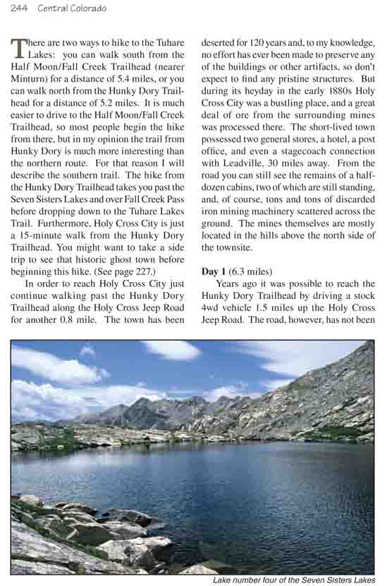
the first of the Seven Sisters Lakes. The Seven Sisters are a collection of
seven small, rocky lakes on the west side of Fall Creek Pass. The terrain
here is all well above timberline, and the lakes all possess a kind of
harsh, rugged beauty that can only be found at this elevation. The trail
passes near five of the lakes on its way up to the pass, with two others
being higher up against the base of the Holy Cross Ridge west of the trail.
The second lake is actually just a tiny pond that you will see on your left
15 minutes after leaving the first lake. It hardly qualifies as a lake by my
definition, but I guess "Seven Sisters" sounds more interesting than the
"Six Sisters Lakes".
Shortly after passing the baby sister lake the trail goes
between two more lakes as it climbs steadily toward the highest point of
this hike. Another 15 minutes will bring you to the last lake, and just
beyond that you will be on the summit of Fall Creek Pass. As you cross to
the east side of the pass you will notice the presence of much more
vegetation than could be found on the rocky west side. The trail descends
through a broad, flat alpine meadow that seems to be filled with fat, lazy
marmots. For the first 0.7 mile after crossing Fall Creek Pass the trail
makes a leisurely descent through thick blankets of wildflowers (late July
to mid August) before turning north to begin a much more serious descent
into Fall Creek Valley.
As you cross timberline the trail passes another small
but delightfully pretty alpine lake as the views to the north open before
you. Lake Constantine is soon visible directly ahead, and in the back of a
distant alpine basin on your left your eyes will be drawn to a long graceful
waterfall that cascades down from an unseen source. Actually, the source of
this magnificent waterfall is the lower Tuhare Lake, your next day’s
destination. The trail you must follow to reach the lake climbs just to the
right of the waterfall.
Finally, after loosing 1,100 feet from the summit of Fall
Creek Pass, the trail arrives at Fall Creek. Upon crossing the stream on a
primitive log bridge you will see a sign marking the Tuhare Lakes Trail
junction. The elevation where the trail crosses the creek is still 11,500
feet, which would be above the tree line in many parts of Colorado, but here
the forest is well timbered. There are a number of fine campsites in this
area, and you probably will not want to climb to the Tuhare Lakes until the
next day. The lakes and the waterfalls are prettiest in the morning when the
sun is in the east.
If you are looking for privacy you might want to consider
another campsite a short distance up the Tuhare Lakes Trail. This site is
located 0.3 mile from the trail junction in a very pleasant area near a pond
on the left side of the trail. The disadvantage is that this site is about
300 feet higher than the trail junction, and some scrambling is required to
get there. In general, you will find that the Tuhare Lakes Trail is much
more primitive than the Fall Creek Trail, with some hand over hand
scrambling required in a few places. This can be a problem if you are
carrying a heavy backpack.
If it is still early in the day my choice would be to
continue down the Fall Creek Trail for another 0.5 mile to Lake Constantine
where there are many attractive lake side campsites, especially on the south
and west sides of the lake. Constantine is a good-sized lake, over 0.3 mile
long and 100 yards wide. It is well timbered with Engelmann spruce, and if
you are packing a fishing pole you will find that the fishing is not bad.
Day 2 (8.0 miles)
In order to see the Tuhare Lakes you must backtrack 0.5
mile from Lake Constantine to the trail junction and turn right. As noted
before, this is a primitive trail with a good deal of elevation gain, so it
is best to leave your backpack at the Tuhare Lakes trail junction before
beginning the climb. Within just a few minutes of leaving Fall Creek the
trail comes to a granite outcropping where some scrambling is necessary.
Following that it reaches a plateau where you can enjoy a few minutes of
level ground before again continuing the climb. The waterfall on the north
side of the canyon will be in full view as you continue upward, and the
scenery just keeps getting better.
The trail climbs steadily up the right side of the
stream, passing the northeast side of the waterfall, before finally reaching
level ground again on the east side of Lower Tuhare Lake. Again, you are
well above timberline at this point, so don’t expect any shade. The trail to
the upper lake continues around the northern side of the lower lake and
follows the north side of the drainage upward for another 275 feet of
elevation gain. Once again, there is a waterfall below the outlet of the
upper lake, and the trail climbs up the north side of the fall. Finally,
just below the upper lake the trail drops into the creek itself where you
must depend on a series of stepping stones to avoid getting you feet wet.
The lake will greet you as you step out of the drainage.
Nestled snugly against the east side of Holy Cross Ridge at an altitude
of 12,365 feet, Upper Tuhare Lake is very cold, very remote, very pristine,
and very big-more than twice the size of the lower lake. It is unusual to
find such a large lake so high in the mountains of Colorado. The Holy Cross
Ridge which provides the backdrop for upper Tuhare Lake is punctuated by two
unnamed high thirteeners, the one on the northeast side of the lake being
just 169 feet shy of 14,000 feet. The fabled Mount of the Holy Cross (14,005
ft.) is unfortunately not visible from the lake shore, although it lies at
the top of the ridge only a mile north of the upper lake.