There were few good roads in Colorado before the turn of
the century, and one of the greatest challenges faced by miners was
transportation. Discovering the gold or silver was often the easy part.
After a claim was staked the early miners were faced with the problem of
getting their ore to a mill and bringing in tons of equipment so they could
process the ore closer to the mine. They often struggled mightily to build
roads and trails through the rugged mountains without the help of modern
machinery.
The Bear Creek Trail now stands as a monument to the
determination and perseverance of Colorado’s nineteenth century miners. It
was originally built in the mid-1870s, and rerouted to its present location
20 years later. The old trail follows an unlikely route up Bear Creek,
through a canyon that is so rugged it is often impossible to reach the water
without ropes. Progress was frequently impeded by the sheer cliffs above the
creek, and in some places the workers were forced to dynamite horizontal
shelves into the rock in order to traverse the vertical walls. The trail
passes by the remains of two hundred-year-old mining camps along the creek,
both of which once had stamping mills for crushing and processing the ore.
From the Bear Creek Trailhead the trail first climbs
50 feet to the top of the highway tunnel and then doubles back over the
tunnel to the east side of the road. Then, immediately after crossing
the road, it begins climbing through a long tiring series of nine
switchbacks up the side of the Uncompahgre Gorge. After gaining 900 feet
in 0.9 mile the trail finally levels out at 9,400 feet. Notice the
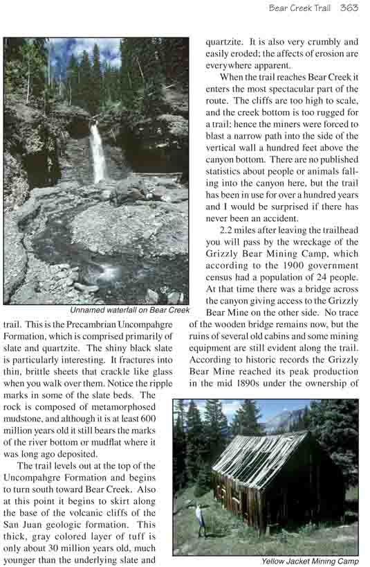
composition of the rock as you climb through the first mile of the
trail. This is the Precambrian Uncompahgre Formation, which is comprised
primarily of slate and quartzite. The shiny black slate is particularly
interesting. It fractures into thin, brittle sheets that crackle like
glass when you walk over them. Notice the ripple marks in some of the
slate beds. The rock is composed of metamorphosed mudstone, and although
it is at least 600 million years old it still bears the marks of the
river bottom or mudflat where it was long ago deposited.
The trail levels out at the top of the Uncompahgre
Formation and begins to turn south toward Bear Creek. Also at this point
it begins to skirt along the base of the volcanic cliffs of the San Juan
geologic formation. This thick, gray colored layer of tuff is only about
30 million years old, much younger than the underlying slate and
quartzite. It is also very crumbly and easily eroded; the affects of
erosion are everywhere apparent.
When the trail reaches Bear Creek it enters the most
spectacular part of the route. The cliffs are too high to scale, and the
creek bottom is too rugged for a trail; hence the miners were forced to
blast a narrow path into the side of the vertical wall a hundred feet above
the canyon bottom. There are no published statistics about people or animals
falling into the canyon here, but the trail has been in use for over a
hundred years and I would be surprised if there has never been an accident.
2.2 miles after leaving the trailhead you will pass by
the wreckage of the Grizzly Bear Mining Camp, which according to the 1900
government census had a population of 24 people. At that time there was a
bridge across the canyon giving access to the Grizzly Bear Mine on the other
side. No trace of the wooden bridge remains now, but the ruins of several
old cabins and some mining equipment are still evident along the trail.
According to historic records the Grizzly Bear Mine reached its peak
production in the mid 1890s under the ownership of George and Ed Wright and
Milton Moore. In all, some $600,000 worth of silver and gold were extracted
from the mine before it was closed.
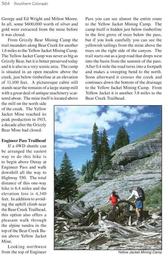
From Grizzly Bear Mining Camp the trail meanders along
Bear Creek for another 1.6 miles to the Yellow Jacket Mining Camp. The
Yellow Jacket Camp was never as big as Grizzly Bear, but it is better
preserved today and it is also in a very scenic area. The camp is situated
in an open meadow above the creek, just below timberline at an elevation of
11,100 feet. A picturesque cabin still stands near the remains of a large
stamp mill with a great deal of antique machinery scattered about. The mine
itself is located above the mill on the north side of the creek. The Yellow
Jacket Mine reached its peak production in 1915, a decade after the Grizzly
Bear Mine had closed.
Engineer Pass Trailhead
If a 4WD shuttle can be arranged the easiest way to do
this hike is to begin above Ouray at Engineer Pass and walk downhill all the
way to Highway 550. The total distance of this one-way hike is 6.4 miles and
the elevation loss is 4,340 feet. In addition to avoiding the uphill climb
near the Bear Creek Trailhead, this option also offers a pleasant walk
through the alpine tundra in the top of the Bear Creek Basin above Yellow
Jacket Mine.
Looking northwest from the top of Engineer Pass you can see almost the
entire route to the Yellow Jacket Mining Camp. The camp itself is hidden
just below timberline in the first grove of trees below the pass, but if you
look carefully you can see the yellowish tailings from the mine above the
trees on the right side of the canyon. The trail starts out as a jeep road
that drops west into the basin from the summit of the pass. After 0.4 mile
the road turns into a footpath and makes a sweeping bend to the north. Soon
afterward it crosses the creek and continues down the bottom of the drainage
to the Yellow Jacket Mining Camp. From Yellow Jacket it is another 3.8 miles
to the Bear Creek Trailhead.