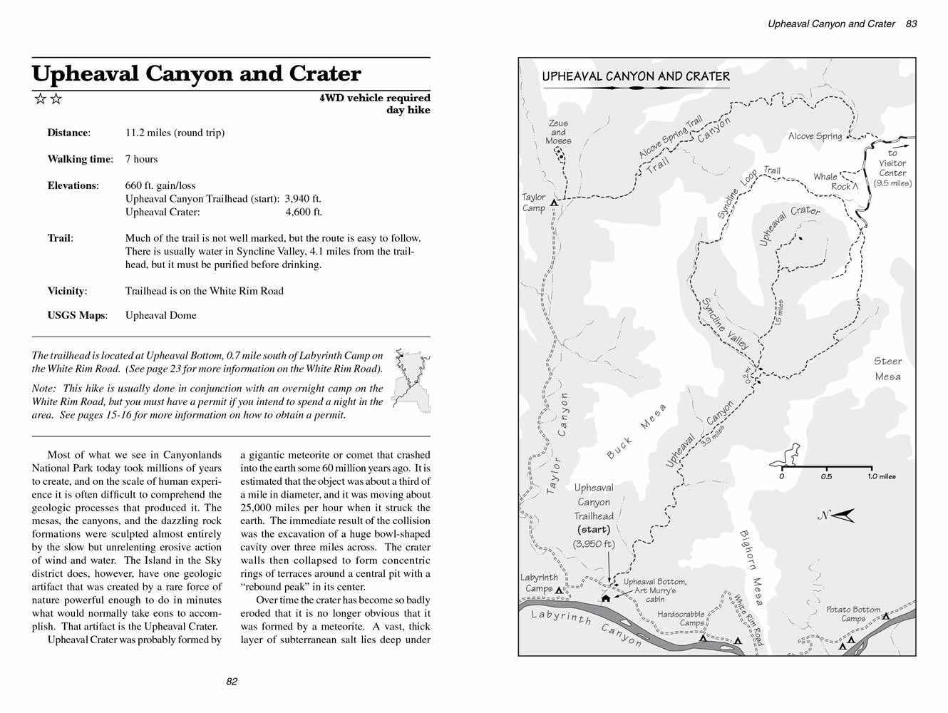
Upheaval Canyon and Crater
excerpted from our book
Canyonlands National Park
Favorite Jeep Roads & Hiking Trails
pages 82-85
|
Buy book directly from the author!
Canyonlands National Park
Favorite Jeep Roads & Hiking Trails
- has access info for 75 trailheads
- 56 detailed trail maps
- 241 photographs
- loads of driving and hiking tips
|
regularly $14.95
now on sale for only
$11.95
click here
for book orders
|
 Most of what we see in Canyonlands National Park today took millions of years to create, and on the scale of human experience it
is often difficult to comprehend the geologic processes that produced it. The mesas, the canyons, and the dazzling rock formations were sculpted almost
entirely by the slow but unrelenting erosive action of wind and water. The Island in the Sky district does, however, have one geologic artifact that
was created by a rare force of nature powerful enough to do in minutes what would normally take eons to accomplish. That artifact is the Upheaval
Crater.
Most of what we see in Canyonlands National Park today took millions of years to create, and on the scale of human experience it
is often difficult to comprehend the geologic processes that produced it. The mesas, the canyons, and the dazzling rock formations were sculpted almost
entirely by the slow but unrelenting erosive action of wind and water. The Island in the Sky district does, however, have one geologic artifact that
was created by a rare force of nature powerful enough to do in minutes what would normally take eons to accomplish. That artifact is the Upheaval
Crater.
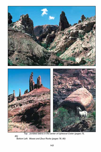
Upheaval Crater was probably formed by a gigantic meteorite or comet that crashed into the earth some 60 million years ago. It is estimated that the
object was about a third of a mile in diameter, and it was moving about 25,000 miles per hour when it struck the earth. The immediate result of the
collision was the excavation of a huge bowl-shaped cavity over three miles across. The crater walls then collapsed to form concentric rings of terraces
around a central pit with a “rebound peak” in its center.
Over time Upheaval Crater has become so badly eroded that it is no longer obvious that it was formed by a meteorite. A vast, thick layer of subterranean salt
lies deep under the park, and until recently most geologists thought the crater and its central peak had been formed by a swelling and shrinking of the
underlying salt. However according to a recent seismic study the top of the salt layer under the crater is almost perfectly flat, and there is no
evidence of any previous swelling or shrinking. That plus other studies of the rock in and around
Upheaval Crater make it much more likely that structure
is an ancient meteor crater.
The Upheaval Canyon Trail begins near the Green River in an area known as Upheaval Bottom. Upheaval
Canyon and Taylor Canyon both meet here to form a wide,
flat sandy area nearly a mile across. The Upheaval Canyon Trail winds across this flat desert in an easterly direction, then the canyon quickly narrows to a width of
about 0.3 mile. The route never strays far from the dry wash in the canyon floor.
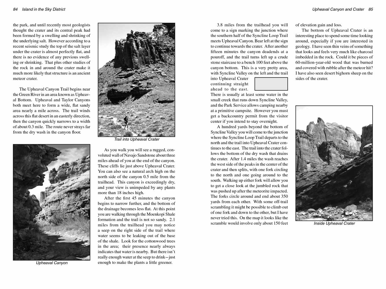 As you walk you will see a rugged, convoluted wall of Navajo Sandstone about three miles ahead of you at the end of the canyon.
These cliffs lie just above Upheaval Crater. You can also see a natural arch high on the north side of the canyon 0.5 mile from the trailhead. This
canyon is exceedingly dry, and your view is unimpeded by any plants more than 18 inches high.
As you walk you will see a rugged, convoluted wall of Navajo Sandstone about three miles ahead of you at the end of the canyon.
These cliffs lie just above Upheaval Crater. You can also see a natural arch high on the north side of the canyon 0.5 mile from the trailhead. This
canyon is exceedingly dry, and your view is unimpeded by any plants more than 18 inches high.
After the first 45 minutes the canyon begins to narrow further, and the bottom of the drainage becomes less flat. At this point you are walking through
the Moenkopi Shale formation and the Upheaval Canyon Trail is not so sandy. 2.1 miles from the trailhead you may notice a seep on the right side of the trail where
water seems to be leaking out of the base of the shale. Look for the cottonwood trees in the area; their presence nearly always indicates that water
is nearby. But there isn’t really enough water at the seep to drink-just enough to make the plants a little greener.
3.8 miles from the trailhead you will come to a sign marking the junction where the southern half of the Syncline Loop Trail meets Upheaval Canyon. Bear
left at the sign to continue towards the crater. After another fifteen minutes the canyon deadends at a pouroff, and the trail turns left up a crude
stone staircase to a bench 100 feet above the canyon bottom. This is a very pretty area, with Syncline Valley on the left and the trail into Upheaval
Crater continuing straight ahead to the east. There is usually at least some water in the small creek that runs down Syncline Valley, and the Park
Service allows camping nearby at a primitive campsite. However you must get a backcountry permit from the visitor center if you intend to stay
overnight.
A hundred yards beyond the bottom of Syncline Valley you will come to the junction where the Syncline Loop Trail departs to the north and the trail into
Upheaval Crater continues to the east. The trail into the crater follows the bottom of the dry wash that drains the crater. After 1.4 miles the wash
reaches the west side of the peaks in the center of the crater and then splits, with one fork circling to the north and one going around to the south.
Walking up either fork will allow you to get a close look at the jumbled rock that was pushed up after the meteorite impacted. The forks circle
around and end about 350 yards from each other. With some off-trail scrambling it might be possible to climb out of one fork and down to the other,
but I have never tried this. On the map it looks like the scramble would involve only about 150 feet of elevation gain and loss.
The bottom of Upheaval Crater is an interesting place to spend some time looking around, especially if you are interested in geology. I have seen thin
veins of something that looks and feels very much like charcoal imbedded in the rock. Could it be pieces of 60-million-year-old wood that was burned
and covered with rubble after the meteor hit? I have also seen desert bighorn sheep on the sides of the crater.
Note to web developers: You may copy this material onto your site, but in return please include a link to my home page
www.utahtrails.com. Thank you, David Day (utahdavidday at gmail.com)
Click here to see more trails in
Canyonlands National Park
© Rincon Publishing Company, all rights reserved
|