Shot and Water Canyons
excerpted from our book
Canyonlands National Park
Favorite Jeep Roads & Hiking Trails
pages 257-261
|
Buy book directly from the author!
Canyonlands National Park
Favorite Jeep Roads & Hiking Trails
- has access info for 75 trailheads
- 56 detailed trail maps
- 241 photographs
- loads of driving and hiking tips
|
regularly $14.95
now on sale for only
$11.95
click here
for book orders
|
 These two interesting canyons run roughly parallel for a distance of four miles east of the Land of Standing Rocks; hence they present a fine opportunity for a loop hike into the Maze. Be cautioned, however, that the seldom-used trails are primitive, and at one point a
good deal of scrambling is required. If you are a seasoned hiker looking for something more challenging than usual this might be just the hike you are looking for. But if you haven’t had much experience climbing in and out of canyons I wouldn’t recommend it.
These two interesting canyons run roughly parallel for a distance of four miles east of the Land of Standing Rocks; hence they present a fine opportunity for a loop hike into the Maze. Be cautioned, however, that the seldom-used trails are primitive, and at one point a
good deal of scrambling is required. If you are a seasoned hiker looking for something more challenging than usual this might be just the hike you are looking for. But if you haven’t had much experience climbing in and out of canyons I wouldn’t recommend it.
Shot Canyon was grazed by livestock in the early 1900s; consequently the trail into this canyon is not too bad. But the trail out of Water Canyon is another story. Water Canyon ends at the base of a 400-foot cliff of Cedar Mesa Sandstone that appears at first glance to be almost unscalable. You will find a feasible route to the top, however, if you follow the cairns carefully. The circuitous trail passes along a series of ledges that eventually lead to the rim on the south side of the canyon. Some hand-over-hand scrambling is required in a few places, but anyone with some agility and a small amount of climbing experience should be able to handle it. The only caveat is that you should not be unduly afraid of heights. There are several places along the way with a fair amount of exposure, and a misstep could be disastrous.
If you are carrying a backpack on this hike be sure to include a 30-foot length of rope for pulling up your gear in a few places. It is much easier to climb if you are not encumbered by a pack. Also, your shoes should have good rubber soles for maximum traction on the slickrock. There are a couple of places where you will be required to friction walk up a 30-degree incline of smooth sandstone. Finally, don’t attempt the climb out of Water Canyon if the weather is bad or if there is ice on the trail.
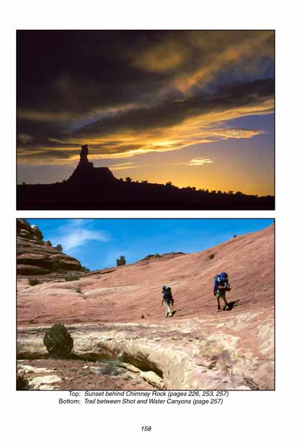
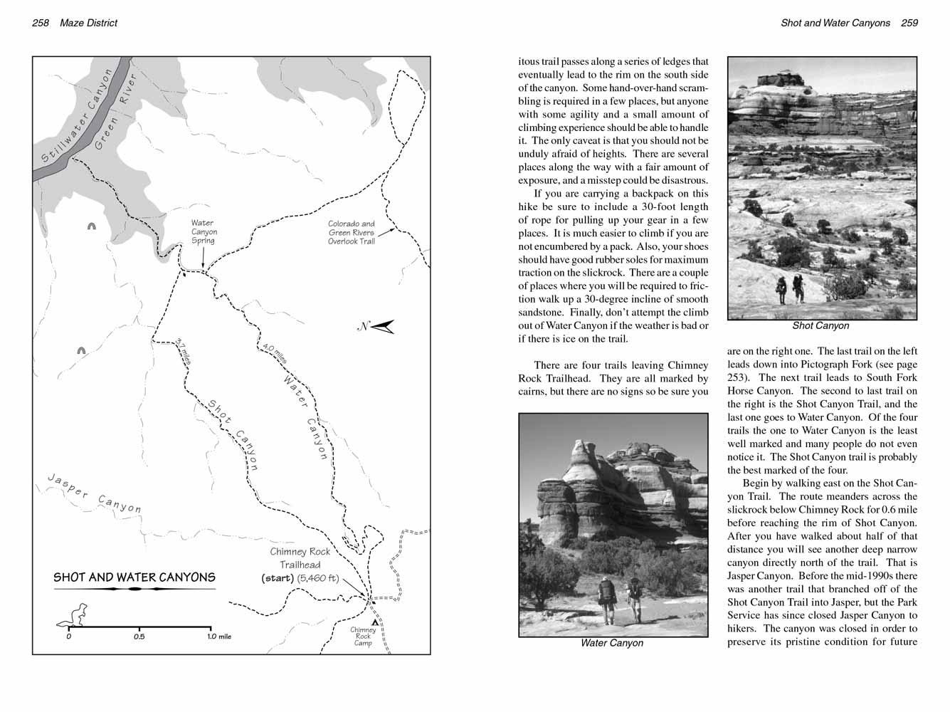
There are four trails leaving Chimney Rock Trailhead. They are all marked by cairns, but there are no signs so be sure you are on the right one. The last trail on the left leads down into Pictograph Fork (see page 253). The next trail leads to South Fork Horse Canyon. The second to last trail on the right is the Shot Canyon Trail, and the last one goes to Water Canyon. Of the four trails the one to Water Canyon is the least well marked and many people do not even notice it. The Shot Canyon trail is probably the best marked of the four.
Begin by walking east on the Shot Canyon Trail. The route meanders across the slickrock below Chimney Rock for 0.6 mile before reaching the rim of Shot Canyon. After you have walked about half of that distance you will see another deep narrow canyon directly north of the trail. That is Jasper Canyon. Before the mid-1990s there was another trail that branched off of the Shot Canyon Trail into Jasper, but the Park Service has since closed Jasper Canyon to hikers. The canyon was closed in order to preserve its pristine condition for future scientific study. Jasper was never grazed by cattle and sheep ranchers; consequently the distribution of native plants within its confines is very close to what it was in all of Canyonlands before the arrival of white men in the late 1800s.
Soon the trail arrives on the rim of Shot Canyon and starts working its way down to the bottom. Notice the crude stairs made from rocks piled up against a long sloping face of slickrock not far from the top. This part of the trail was probably built by an old forgotten sheepherder a century ago. It has been in place as long as anyone now alive can remember. Below the slickrock the trail switchbacks a few times and continues its steady descent to the canyon bottom 400 feet below the rim. Once it reaches the bottom it strikes out in a northeasterly direction across a wide, open flat of grass and sage towards the Green River.
 As mentioned earlier, Shot Canyon was used by local ranchers in the early 1900s as a pasture for livestock. There was plenty of feed in the canyon at that time but, unfortunately, no reliable water. In order to get water the animals had to walk across a low pass near the end of Shot Canyon to an excellent spring in nearby Water Canyon. In the late 1920s the ranchers dynamited a few sections of the trail across the pass to make it easier for cows to get into Water Canyon, and my guess is that is how Shot Canyon got its name.
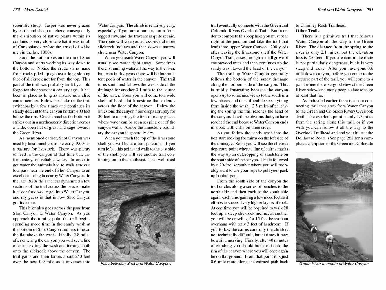
This hike also goes across the pass from Shot Canyon to Water Canyon. As you approach the turning point the trail begins spending more time in the sandy wash at the bottom of Shot Canyon and less time on the flat above the wash. Finally, 2.8 miles after entering the canyon you will see a line of cairns exiting the wash and turning south onto the slickrock above the canyon. The trail gains and then looses about 250 feet over the next 0.9 mile as it traverses into Water Canyon. The climb is relatively easy, especially if you are a human, not a four-legged cow, and the traverse is quite scenic. The route will take you across several more slickrock inclines and then down a narrow chute near Water Canyon.
When you reach Water Canyon you will usually see water right away. Sometimes there is running water all the way to the river, but even in dry years there will be intermittent pools of water in the canyon. The trail turns south and follows the west side of the drainage for another 0.1 mile to the source of the water. Soon you will come to a wide shelf of hard, flat limestone that extends across the floor of the canyon. Below the limestone the canyon floor drops abruptly for 30 feet to a spring, the first of many places where water can be seen seeping out of the canyon walls. Above the limestone boundary the canyon is generally dry.
 When you reach the top of the limestone shelf you will be at a trail junction. If you turn left at this point and walk to the east side of the shelf you will see another trail continuing on to the southeast. That well-used trail eventually connects with the Green and Colorado Rivers Overlook Trail. But in order to complete this loop hike you must bear right at the junction and take the trail that leads into upper Water Canyon. 200 yards after leaving the limestone shelf the Water Canyon Trail passes through a small grove of cottonwood trees and then continues up the sandy wash toward the head of the canyon.
The trail up Water Canyon generally follows the bottom of the sandy drainage along the northern side of the canyon. This is mildly frustrating because the canyon opens up to some nice views to the south in a few places, and it is difficult to see anything from inside the wash. 2.5 miles after leaving the spring the trail reaches the head of the canyon. It will be obvious that you have reached the end because Water Canyon ends in a box with cliffs on three sides.
As you follow the sandy wash into the box start looking for cairns on the left side of the drainage. Soon you will see the obvious departure point where a line of cairns marks the way up an outcropping of sandstone on the south side of the canyon. This is followed by a 20-foot scramble where you will probably want to use your rope to pull your pack up behind you.
From the south side of the canyon the trail circles along a series of benches to the north side and then back to the south side again, each time gaining a few more feet as it climbs to successively higher layers of rock. At one time you will be required to walk 20 feet up a steep slickrock incline, at another you will be crawling for 15 feet beneath an overhang with only 3 feet of headroom. If you follow the cairns carefully the climb is not technically difficult, but at times it may be a bit unnerving. Finally, after 40 minutes of climbing you should break out onto the rim of the canyon where you will once again be on flat ground. From that point it is just 0.6 mile more along the cairned path back to Chimney Rock Trailhead.
Other Trails
There is a primitive trail that follows Water Canyon all the way to the Green River. The distance from the spring to the river is only 2.1 miles, but the elevation loss is 750 feet. If you are careful the route is not particularly dangerous, but it is very steep and rocky. After you have gone 0.6 mile down-canyon, before you come to the steepest part of the trail, you will come to a point where there is a good view of the Green River below, and many people choose to go at least that far.
As indicated earlier there is also a connecting trail that goes from Water Canyon to the Green and Colorado Rivers Overlook Trail. The overlook point is only 1.7 miles from the spring along this trail, or if you wish you can follow it all the way to the Overlook Trailhead and end your hike at the Dollhouse Road. (See page 262 for a complete description of the Green and Colorado Rivers Overlook Trail.)
Note to web developers: You may copy this material onto your site, but in return please include a link to my home page
www.utahtrails.com. Thank you, David Day (utahdavidday at gmail.com)
Click here to see more trails in
Canyonlands National Park
© Rincon Publishing Company, all rights reserved
|