Salt Creek Canyon Trail
excerpted from our book
Canyonlands National Park
Favorite Jeep Roads & Hiking Trails
pages 189-200
|
Buy book directly from the author!
Canyonlands National Park
Favorite Jeep Roads & Hiking Trails
- has access info for 75 trailheads
- 56 detailed trail maps
- 241 photographs
- loads of driving and hiking tips
|
regularly $14.95
now on sale for only
$11.95
click here
for book orders
|
 Salt Creek Canyon is one of those special places in Canyonlands National Park where water is generally available throughout the year.
The canyon is a green oasis in the midst of a redrock desert, and the combination of the two ecosystems makes this hike unique.
The trail alternately winds across the sage-covered benches above the creek, then drops down to carve a path through the willows and cottonwoods that grow nearer the water.
The backdrop for the canyon greenery is a mural of red, white and black Cedar Mesa Sandstone, etched and sculpted into pinnacles, alcoves, natural arches, and a million other unusual shapes.
Salt Creek Canyon is one of those special places in Canyonlands National Park where water is generally available throughout the year.
The canyon is a green oasis in the midst of a redrock desert, and the combination of the two ecosystems makes this hike unique.
The trail alternately winds across the sage-covered benches above the creek, then drops down to carve a path through the willows and cottonwoods that grow nearer the water.
The backdrop for the canyon greenery is a mural of red, white and black Cedar Mesa Sandstone, etched and sculpted into pinnacles, alcoves, natural arches, and a million other unusual shapes.
Perhaps the most interesting features on the canyon walls are the ancient cliff dwellings and rock art that were left behind by the Anasazi and Fremont Indians centuries ago.
The cliffs are littered with their ancient pictographs, and dozens of prehistoric granaries and other structures lie hidden away in the dark recesses of the sandstone.
Their’s was a farming culture, and they must have found the sandy, flat-bottomed canyon an ideal place to grow their crops.
Salt Creek Canyon was also a grazing area for cattle during the first half of the twentieth century, and relics of the old ranching activity can still be seen occasionally along the trail.
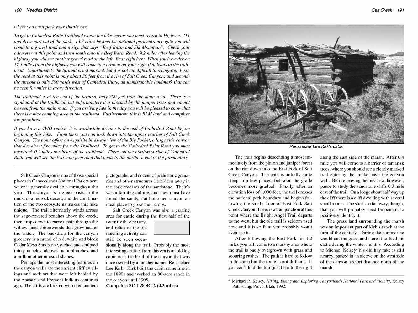
Probably the most interesting artifact from this era is an old log cabin near the head of the canyon that was once owned by a rancher named Rensselaer Lee Kirk.
Kirk built the cabin sometime in the 1890s and worked an 80-acre ranch in the canyon until 1905.
Campsites SC-1 & SC-2 (4.3 miles)
The trail begins descending almost immediately from the pinion and juniper forest on the rim down into the East Fork of Salt Creek Canyon.
The path is initially quite steep in a few places, but soon the grade becomes more gradual.
Finally, after an elevation loss of 1,000 feet, the trail crosses the national park boundary and begins following the sandy floor of East Fork Salt Creek Canyon.
There is a trail junction at this point where the Bright Angel Trail departs to the west, but the old trail is seldom used now, and it is so faint you probably won’t even see it.
After following the East Fork for 1.2 miles you will come to a marshy area where the
Salt Creek Canyon trail is badly overgrown with grass and scouring rushes.
The path is hard to follow in this area but the route is not difficult. If you can’t find the trail just bear to the right along the east side of the marsh.
After 0.4 mile you will come to a barrier of tamarisk trees, where you should see a clearly marked trail entering the thicket near the canyon wall.
Before leaving the meadow, however, pause to study the sandstone cliffs 0.3 mile east of the trail. On a ledge about half way up the cliff there is a cliff dwelling with several small rooms.
The site is so far away, though, that you will probably need binoculars to positively identify it.
 The grass land surrounding the marsh in Salt Creek Canyon was an important part of Kirk’s ranch at the turn of the
last century.
During the summer he would cut the grass and store it to feed his cattle during the winter months.
According to Michael Kelsey his old hay rake is still nearby, parked in an alcove on the west side of the canyon a short distance north of the marsh.
The grass land surrounding the marsh in Salt Creek Canyon was an important part of Kirk’s ranch at the turn of the
last century.
During the summer he would cut the grass and store it to feed his cattle during the winter months.
According to Michael Kelsey his old hay rake is still nearby, parked in an alcove on the west side of the canyon a short distance north of the marsh.
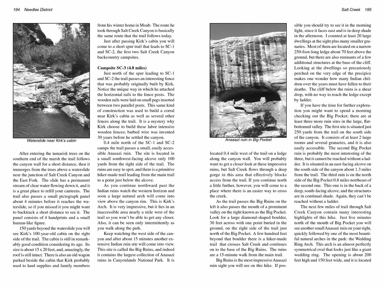
After entering the tamarisk trees on the southern end of the marsh the trail follows the canyon wall for a short distance,
then it immerges from the trees above a waterslide near the junction of Salt Creek Canyon and the East Fork.
The slide has a permanent stream of clear water flowing down it, and it is a great place to refill your canteens.
The trail also passes a small pictograph panel about 4 minutes before it reaches the waterslide, so if you missed it you might want to backtrack a short distance to see it.
The panel consists of 4 handprints and a small human-like figure.
150 yards beyond the waterslide you will see Kirk’s 125-year-old cabin on the right side of the trail.
The cabin is still in remarkably good condition considering its age. Its size is about 15 x 20 feet, and, amazingly, the roof is still intact.
There is also an old wagon parked beside the cabin that Kirk probably used to haul supplies and family members from his winter home in Moab.
The route he took through Salt Creek Canyon is basically the same route that the trail follows today.
Just after passing Kirk’s cabin you will come to a short spur trail that leads to SC-1 and SC-2, the first two Salt Creek Canyon backcountry campsites.
Campsite SC-3 (4.8 miles)
Just north of the spur leading to SC-1 and SC-2 the trail passes an interesting fence that was probably originally built by Kirk.
Notice the unique way in which he attached the horizontal rails to the fence posts. The wooden rails were laid on small pegs inserted between two parallel posts.
This same kind of construction was used to build a corral near Kirk’s cabin as well as several other fences along the trail.
It is a mystery why Kirk choose to build these labor intensive wooden fences; barbed wire was invented 30 years before he settled the Salt Creek
Canyon.
0.4 mile north of the SC-1 and SC-2 camps the trail passes a small, easily accessible Anasazi ruin.
The site is located in a small southwest-facing alcove only 100 yards from the right side of the trail.
The ruins are easy to spot, and there is a primitive hiker-made trail leading from the main trail to a point just below the alcove.
As you continue northward past the Indian ruins watch the western horizon and soon a large natural arch will come into view above the canyon rim.
This is Kirk’s Arch. It is very impressive, but it lies in an inaccessible area nearly a mile west of the trail so you won’t be able to get any closer.
Also, it can be seen only intermittently as you walk along the path.
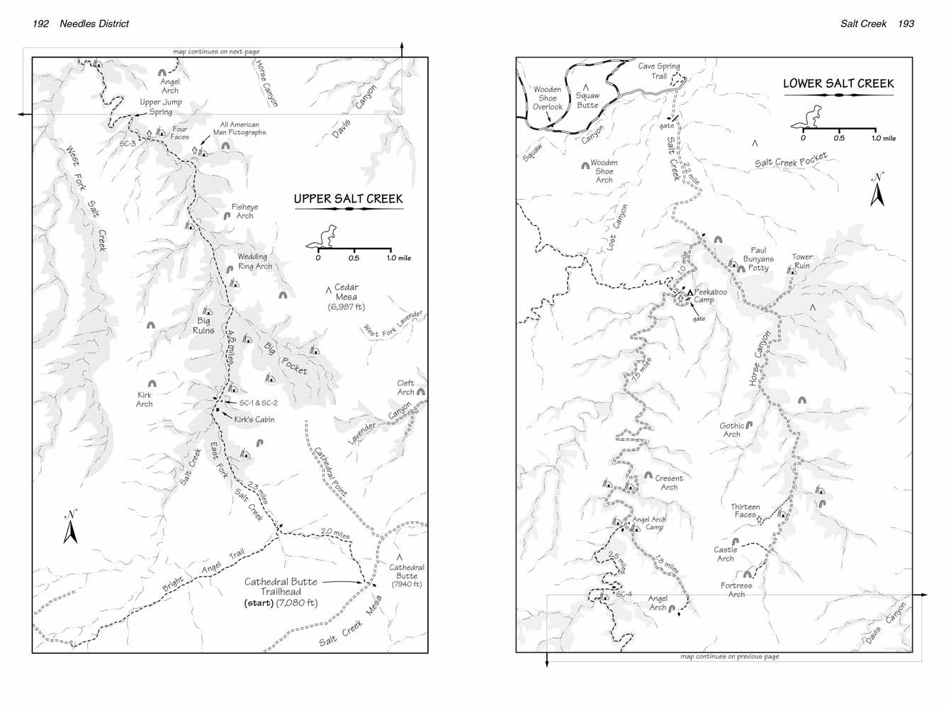 Keep watching the west side of Salt Creek Canyon and after about 15 minutes another extensive Indian ruin site will come into view.
This site is called the Big Ruins, and indeed it contains the largest collection of Anasazi ruins in Canyonlands National Park.
It is located 0.4 mile west of the trail on a ledge along the canyon wall.
You will probably want to get a closer look at these impressive ruins, but Salt Creek flows through a deep gorge in this area that effectively blocks access from the trail.
If you continue north a little further, however, you will come to a place where there is an easier way to cross
Salt Creek.
Keep watching the west side of Salt Creek Canyon and after about 15 minutes another extensive Indian ruin site will come into view.
This site is called the Big Ruins, and indeed it contains the largest collection of Anasazi ruins in Canyonlands National Park.
It is located 0.4 mile west of the trail on a ledge along the canyon wall.
You will probably want to get a closer look at these impressive ruins, but Salt Creek flows through a deep gorge in this area that effectively blocks access from the trail.
If you continue north a little further, however, you will come to a place where there is an easier way to cross
Salt Creek.
As the trail passes the Big Ruins on the left it also passes the mouth of a prominent valley on the right known as the Big Pocket.
Look for a large diamond-shaped boulder, 30 feet across with one point buried in the ground, on the right side of the trail just north of the Big Pocket.
A few hundred feet beyond that boulder there is a hiker-made trail that crosses Salt Creek and continues on to the base of the Big Ruins.
The ruins are a 15-minute walk from the main trail.
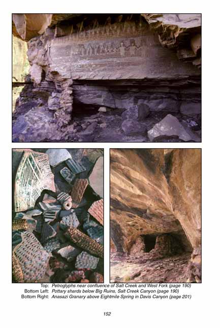
Big Ruins is the most impressive Anasazi ruin sight you will see on this hike. If possible you should try to see it in the morning light, since it faces east and is in deep shade in the afternoon.
I counted at least 20 large dwellings at the sight plus many smaller granaries.
Most of them are located on a narrow 250-foot-long ledge about 70 feet above the ground, but there are also remnants of a few additional structures at the base of the cliff.
Looking at the dwellings so precariously perched on the very edge of the precipice makes one wonder how many Indian children over the years must have fallen to their deaths.
The cliff below the ruins is a shear drop, with no way to reach the ledge except by ladder.
If you have the time for further exploration you might want to spend a morning checking out the Big Pocket; there are at least three more ruin sites in the large, flat-bottomed valley.
The first site is situated just 250 yards from the trail on the south side of the canyon. It consists of at least 2 large rooms and several granaries, and it is also easily accessible.
The second Big Pocket ruin is probably the most interesting of the three, but it cannot be reached without a ladder.
It is situated in an east-facing alcove on the south side of the canyon about 1.3 miles from the trail.
The third ruin is on the north side of the Big Pocket 0.8 miles northeast of the second one. This one is in the back of a deep, south-facing alcove, and the structures are in continual shade.
Again, they can’t be reached without a ladder.
 The next few miles of trail through Salt Creek Canyon contain many interesting highlights of this hike.
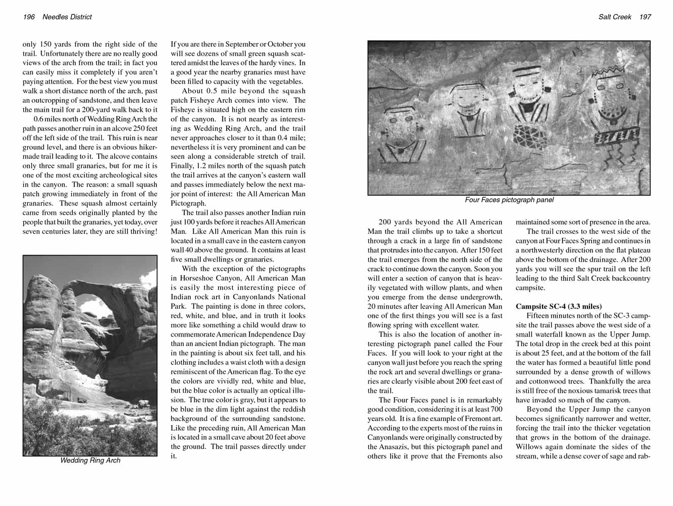
Just five minutes north of the mouth of Big Pocket you will see another small Anasazi ruin on your right, quickly followed by one of the most beautiful natural arches in the park: the Wedding Ring Arch.
This arch is an almost perfectly symmetrical oval that looks just like a giant wedding ring. The opening is about 200 feet high and 150 feet wide, and it is located only 150 yards from the right side of the
Salt Creek Canyon trail.
Unfortunately there are no really good views of the arch from the trail; in fact you can easily miss it completely if you aren’t paying attention.
For the best view you must walk a short distance north of the arch, past an outcropping of sandstone,
and then leave the main trail for a 200-yard walk back to it.
The next few miles of trail through Salt Creek Canyon contain many interesting highlights of this hike.
Just five minutes north of the mouth of Big Pocket you will see another small Anasazi ruin on your right, quickly followed by one of the most beautiful natural arches in the park: the Wedding Ring Arch.
This arch is an almost perfectly symmetrical oval that looks just like a giant wedding ring. The opening is about 200 feet high and 150 feet wide, and it is located only 150 yards from the right side of the
Salt Creek Canyon trail.
Unfortunately there are no really good views of the arch from the trail; in fact you can easily miss it completely if you aren’t paying attention.
For the best view you must walk a short distance north of the arch, past an outcropping of sandstone,
and then leave the main trail for a 200-yard walk back to it.
0.6 miles north of Wedding Ring Arch the path passes another ruin in an alcove 250 feet off the left side of the
Salt Creek Canyon trail.
This ruin is near ground level, and there is an obvious hiker-made trail leading to it.
The alcove contains only three small granaries, but for me it is one of the most exciting archeological sites in
Salt Creek Canyon.
The reason: a small squash patch growing immediately in front of the granaries.
These squash almost certainly came from seeds originally planted by the people that built the granaries, yet today, over seven centuries later, they are still thriving!
If you are there in September or October you will see dozens of small green squash scattered amidst the leaves of the hardy vines.
In a good year the nearby granaries must have been filled to capacity with the vegetables.
About 0.5 mile beyond the squash patch Fisheye Arch comes into view. The Fisheye is situated high on the eastern rim of the canyon.
It is not nearly as interesting as Wedding Ring Arch, and the trail never approaches closer to it than 0.4 mile; nevertheless it is very prominent and can be seen along a considerable stretch of trail.
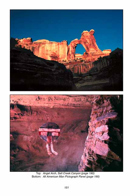
Finally, 1.2 miles north of the squash patch the trail arrives at the canyon’s eastern wall and passes immediately below the next major point of interest: the All American Man Pictograph.
The trail also passes another Indian ruin just 100 yards before it reaches All American Man. Like All American Man
pictograph panel this ruin is located in a small cave in the eastern canyon wall 40 above the ground.
It contains at least five small dwellings or granaries.
With the exception of the pictographs in Horseshoe Canyon,
the All American Man pictograph panel is easily the most interesting piece of Indian rock art in Canyonlands National Park.
The painting is done in three colors, red, white, and blue, and in truth it looks more like something a child would draw to commemorate American Independence Day than an ancient Indian pictograph.
The man in the painting is about six feet tall, and his clothing includes a waist cloth with a design reminiscent of the American flag.
To the eye the colors are vividly red, white and blue, but the blue color is actually an optical illusion.
The true color is gray, but it appears to be blue in the dim light against the reddish background of the surrounding sandstone.
Like the preceding ruin, the All American Man pictograph panel is located in a small cave about 20 feet above the ground. The trail passes directly under it.
 200 yards beyond the All American Man the trail climbs up to take a shortcut through a crack in a large fin of sandstone that protrudes into the canyon.
After 150 feet the trail emerges from the north side of the crack to continue down
Salt Creek Canyon.
Soon you will enter a section of canyon that is heavily vegetated with willow plants, and when you emerge from the dense undergrowth,
20 minutes after leaving All American Man one of the first things you will see is a fast flowing spring with excellent water.
200 yards beyond the All American Man the trail climbs up to take a shortcut through a crack in a large fin of sandstone that protrudes into the canyon.
After 150 feet the trail emerges from the north side of the crack to continue down
Salt Creek Canyon.
Soon you will enter a section of canyon that is heavily vegetated with willow plants, and when you emerge from the dense undergrowth,
20 minutes after leaving All American Man one of the first things you will see is a fast flowing spring with excellent water.
This is also the location of another interesting pictograph panel called the Four Faces.
If you will look to your right at the canyon wall just before you reach the spring the rock art and several dwellings or granaries are clearly visible about 200 feet east of the trail.
The Four Faces panel is in remarkably good condition, considering it is at least 700 years old. It is a fine example of Fremont art.
According to the experts most of the ruins in Canyonlands National Park were originally constructed by the Anasazis,
but this pictograph panel and others like it prove that the Fremonts also maintained some sort of presence in the area.
The trail crosses to the west side of Salt Creek Canyon at Four Faces Spring and continues in a northwesterly direction on the flat plateau above the bottom of the drainage.
After 200 yards you will see the spur trail on the left leading to the third Salt Creek
Canyon backcountry campsite.
Campsite SC-4 (3.3 miles)
Fifteen minutes north of the SC-3 campsite the Salt Creek
Canyon trail passes above the west side of a small waterfall known as the Upper Jump.
The total drop in the creek bed at this point is about 25 feet, and at the bottom of the fall the water has formed a beautiful little pond surrounded by a dense growth of willows and cottonwood trees.
Thankfully the area is still free of the noxious tamarisk trees that have invaded so much of the canyon.
Beyond the Upper Jump Salt Creek Canyon becomes significantly narrower and wetter, forcing the trail into the thicker vegetation that grows in the bottom of the drainage.
Willows again dominate the sides of the stream, while a dense cover of sage and rabbit brush seems to thrive just above the creek.
The trail cuts tunnel-like through the thick ground cover, with eight-foot-high walls of rabbit brush often lining the sides.
For most of the summer the rabbit brush is covered with thousands of tiny yellow flowers, making the walk a delightful one.
 2.3 miles downstream from the upper jump, just before reaching the confluence of West Fork and Salt Creek Canyon,
the trail climbs out of the willows to a dry plateau on the northeast side of the streambed.
The trail then proceeds in a westerly direction, passing within 100 feet of an impressive collection of Anasazi ruins.
The ruins are about 100 feet above the trail on an easily accessible south-facing ledge. I counted at least 15 dwellings and granaries along the 150-yard-long ledge.
On the western end of the ledge there is an interesting pictograph of several human figures that appear to be holding hands like a string of paper dolls.
2.3 miles downstream from the upper jump, just before reaching the confluence of West Fork and Salt Creek Canyon,
the trail climbs out of the willows to a dry plateau on the northeast side of the streambed.
The trail then proceeds in a westerly direction, passing within 100 feet of an impressive collection of Anasazi ruins.
The ruins are about 100 feet above the trail on an easily accessible south-facing ledge. I counted at least 15 dwellings and granaries along the 150-yard-long ledge.
On the western end of the ledge there is an interesting pictograph of several human figures that appear to be holding hands like a string of paper dolls.
Shortly after leaving the archeological site the Salt Creek
Canyon trail drops down from the bench and turns 180 degrees to follow the canyon in an easterly direction.
Within ten minutes after making the turn you should see SC-4, the last designated Salt Creek Canyon campsite on your right.
Angel Arch Camp (2.5 miles)
From SC-4 to the old Salt Creek Canyon jeep road is 2.1 miles. There is at least one more Indian ruin along the way and probably more, but nothing to compare with the previous ones.
The first few hundred yards of the old road are fairly obscure now, so it won’t be immediately obvious when the trail turns into a road.
However by the time you reach the side canyon leading to Angel Arch it will be very clear that you are on an old road.
There, near a weathered signboard, an abandoned but still obvious jeep road leaves Salt Creek Canyon and turns east into the dry wash that ends near the arch.
There are at least two more Indian ruins near the junction of Salt Creek Canyon and what I will call Angel Arch Canyon.
One is directly west of the canyon junction, in a south-facing alcove about 0.1 mile from the trail. The other is a short distance east of the junction on the north wall of Angel Arch Canyon.
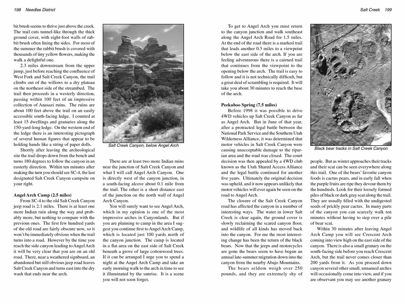
You will surely want to see Angel Arch, which in my opinion is one of the most impressive arches in Canyonlands
National Park.
But if you are planning to camp in the area I suggest you continue first to Angel Arch Camp, which is located just 100 yards north of the canyon junction.
The camp is located in a flat area on the east side of Salt Creek beneath a grove of large cottonwood trees.
If it can be arranged I urge you to spend a night at the Angel Arch Camp and take an early morning walk to the arch in time to see it illuminated by the sunrise. It is a scene you will not soon forget.
 To get to Angel Arch you must return to the canyon junction and walk southeast along the Angel Arch Road for 1.5 miles.
At the end of the road there is a marked trail that leads another 0.3 miles to a viewpoint below the east side of the arch.
If you are feeling adventurous there is a cairned trail that continues from the viewpoint to the opening below the arch.
The trail is easy to follow and it is not technically difficult, but a great deal of scrambling is required. It will take you about 30 minutes to reach the base of the arch.
To get to Angel Arch you must return to the canyon junction and walk southeast along the Angel Arch Road for 1.5 miles.
At the end of the road there is a marked trail that leads another 0.3 miles to a viewpoint below the east side of the arch.
If you are feeling adventurous there is a cairned trail that continues from the viewpoint to the opening below the arch.
The trail is easy to follow and it is not technically difficult, but a great deal of scrambling is required. It will take you about 30 minutes to reach the base of the arch.
Peekaboo Spring (7.5 miles)
Before 1998 it was possible to drive 4WD vehicles up Salt Creek Canyon as far as Angel Arch.
But in June of that year, after a protracted legal battle between the National Park Service and the Southern Utah Wilderness Alliance,
it was determined that motor vehicles in Salt Creek Canyon were causing unacceptable damage to the riparian area and the road was closed.
The court decision was then appealed by a 4WD club known as the Utah Shared Access Alliance and the legal battle continued for another five years.
Ultimately the original decision was upheld, and it now appears unlikely that motor vehicles will ever again be seen on the road to Angel Arch.
The closure of the Salt Creek Canyon road has affected the canyon in a number of interesting ways.
The water in lower Salt Creek is clear again, the ground cover is slowly reclaiming the scared canyon floor, and wildlife of all kinds has moved back into the canyon.
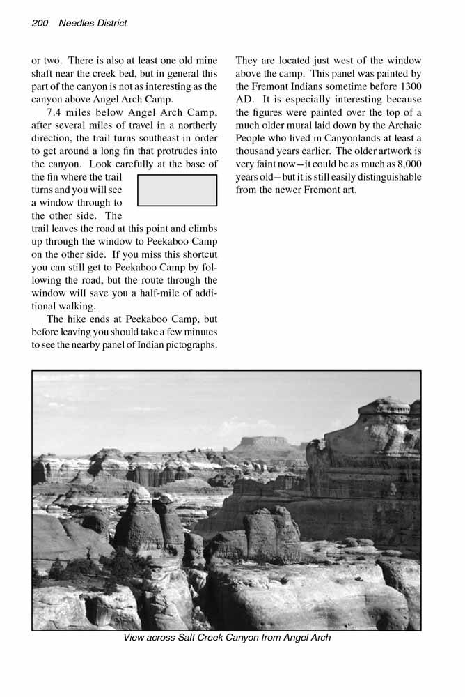
For me the most interesting change has been the return of the black bears.
Now that the jeeps and motorcycles are gone the bears seem to have begun an annual late-summer migration down into the canyon from the nearby Abajo Mountains.
The bears seldom weigh over 250 pounds, and they are extremely shy of people. But as winter approaches their tracks and their scat can be seen everywhere along the
Salt Creek Canyon trail.
One of the bears’ favorite canyon foods is cactus pears, and in early fall when the purple fruits are ripe they devour them by the hundreds.
Look for their loosely formed piles of black or dark gray scat along the trail. They are usually filled with the undigested seeds of prickly pear cactus.
In many parts of the canyon you can scarcely walk ten minutes without having to step over a pile of bear scat.
Within 30 minutes after leaving Angel Arch Camp you will see Crescent Arch coming into view high on the east side of
Salt Creek Canyon.
There is also a small granary on the south-facing side before you reach Crescent Arch, but the trail never comes closer than 200 yards from it.
As you proceed down canyon several other small, unnamed arches will occasionally come into view, and if you are observant you may see another granary or two.
There is also at least one old mine shaft near the creek bed, but in general this part of the Salt Creek
Canyon is not as interesting as the canyon above Angel Arch Camp.
7.4 miles below Angel Arch Camp, after several miles of travel in a northerly direction, the trail turns southeast in order to get around a long fin that protrudes into
Salt Creek Canyon.
Look carefully at the base of the fin where the trail turns and you will see a window through to the other side.
The trail leaves the road at this point and climbs up through the window to Peekaboo Camp on the other side.
If you miss this shortcut you can still get to Peekaboo Camp by following the road, but the route through the window will save you a half-mile of additional walking.
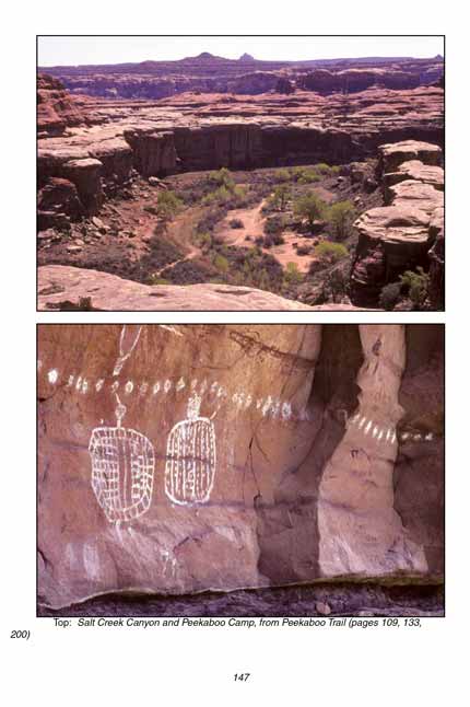
The hike ends at Peekaboo Camp, but before leaving you should take a few minutes to see the nearby panel of Indian pictographs.
They are located just west of the window above the camp. This panel was painted by the Fremont Indians sometime before 1300 AD.
It is especially interesting because the figures were painted over the top of a much older mural laid down by the Archaic People who lived in
Salt Creek Canyon at least a thousand years earlier.
The older artwork is very faint now-it could be as much as 8,000 years old-but it is still easily distinguishable from the newer Fremont art.
Note to web developers: You may copy this material onto your site, but in return please include a link to my home page
www.utahtrails.com. Thank you, David Day (utahdavidday at gmail.com)
Click here to see more trails in
Canyonlands National Park
© Rincon Publishing Company, all rights reserved
|