North Trail
excerpted from our book
Canyonlands National Park
Favorite Jeep Roads & Hiking Trails
pages 234-238
|
Buy book directly from the author!
Canyonlands National Park
Favorite Jeep Roads & Hiking Trails
- has access info for 75 trailheads
- 56 detailed trail maps
- 241 photographs
- loads of driving and hiking tips
|
regularly $14.95
now on sale for only
$11.95
click here
for book orders
|
 North Trail, which descends from North Point into Elaterite Basin, was one of the first trails to penetrate the Under the Rim country.
The first known person to use the trail was a sheep rancher named John Boline who was using Elaterite Basin as a winter grazing pasture as early as the 1890s.
The story goes that when he brought his sheep up from Under the Ledge each spring he would roll rocks onto the trail so other sheepmen couldn’t find it.
North Trail, which descends from North Point into Elaterite Basin, was one of the first trails to penetrate the Under the Rim country.
The first known person to use the trail was a sheep rancher named John Boline who was using Elaterite Basin as a winter grazing pasture as early as the 1890s.
The story goes that when he brought his sheep up from Under the Ledge each spring he would roll rocks onto the trail so other sheepmen couldn’t find it.
At that time there was no Bureau of Land Management and no laws governing grazing on public land.
Many of the ranchers did not even own any land of their own, and success was heavily dependent on finding pastures that the other ranchers did not know about.
Under the Ledge was ideally suited to sheep, and by the 1930s sheepmen had penetrated nearly every canyon in the area.
By the time the Taylor Grazing Act was passed in 1935 it is estimated there were at least 15,000 sheep grazing Under the Ledge.
After the 1930s cattle ranching became more prominent, and eventually the sheep ranchers disappeared altogether.
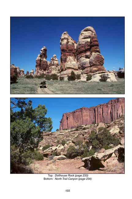
The North Trail begins by meandering gently downward through the trees in a southeasterly direction for 0.4 mile until it reaches a small outcropping of Navajo Sandstone.
Then, after finding a way down through this minor barrier, it turns west and doubles back along a bench for the next 0.9 mile to the head of North Trail Canyon.
When the path finally reaches the head of the canyon it makes a sharp left turn and begins a 150-foot descent through a series of short, steep switchbacks that lead to the bottom of the drainage.
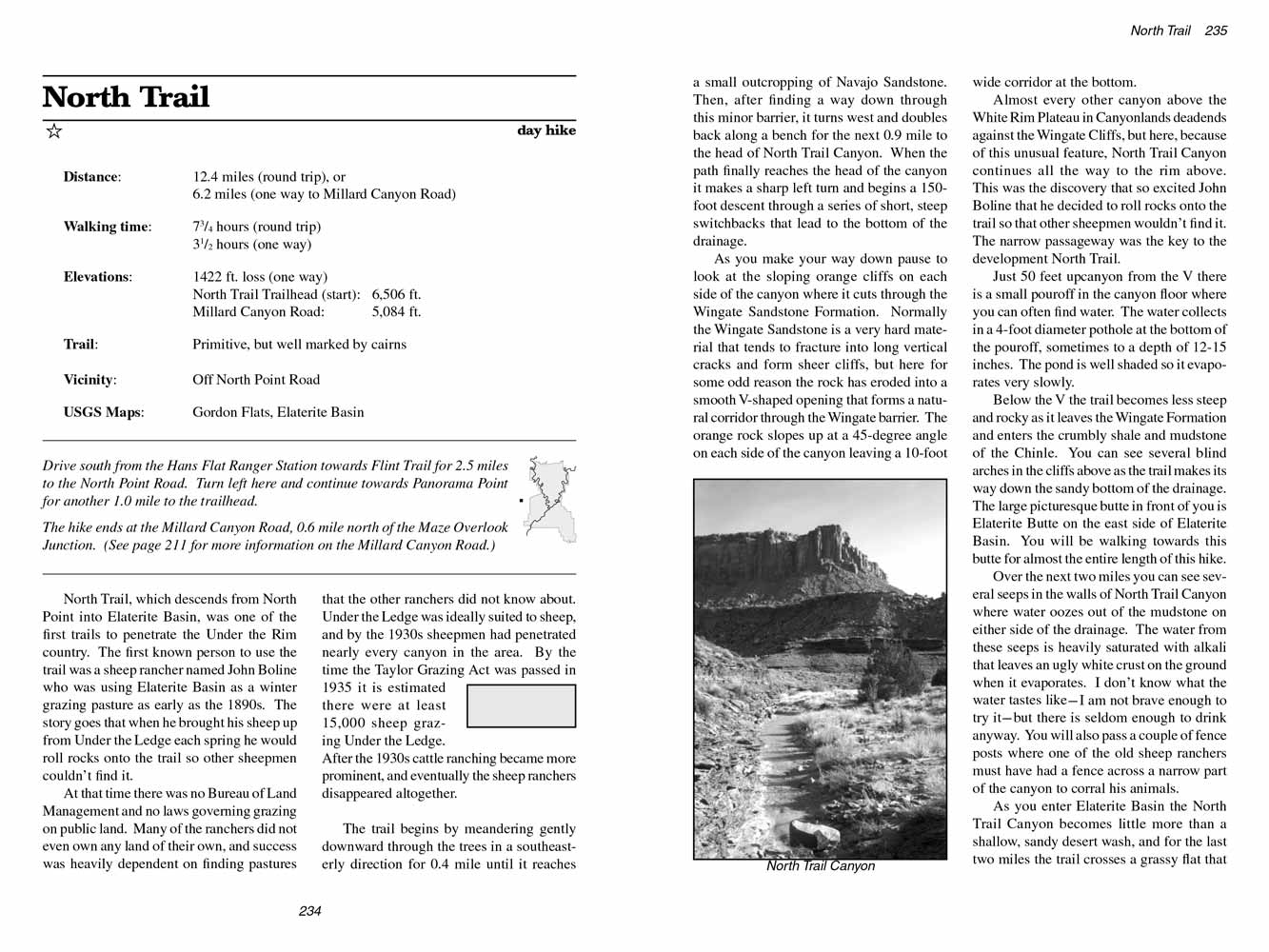
As you make your way down pause to look at the sloping orange cliffs on each side of the canyon where it cuts through the Wingate Sandstone Formation.
Normally the Wingate Sandstone is a very hard material that tends to fracture into long vertical cracks and form sheer cliffs,
but here for some odd reason the rock has eroded into a smooth V-shaped opening that forms a natural corridor through the Wingate barrier.
The orange rock slopes up at a 45-degree angle on each side of the canyon leaving a 10-foot wide corridor at the bottom.
 Almost every other canyon above the White Rim Plateau in Canyonlands deadends against the Wingate Cliffs,
but here, because of this unusual feature, North Trail Canyon continues all the way to the rim above.
This was the discovery that so excited John Boline that he decided to roll rocks onto the trail so that other sheepmen wouldn’t find it. The narrow passageway was the key to the development North Trail.
Almost every other canyon above the White Rim Plateau in Canyonlands deadends against the Wingate Cliffs,
but here, because of this unusual feature, North Trail Canyon continues all the way to the rim above.
This was the discovery that so excited John Boline that he decided to roll rocks onto the trail so that other sheepmen wouldn’t find it. The narrow passageway was the key to the development North Trail.
Just 50 feet upcanyon from the V there is a small pouroff in the canyon floor where you can often find water.
The water collects in a 4-foot diameter pothole at the bottom of the pouroff, sometimes to a depth of 12-15 inches. The pond is well shaded so it evaporates very slowly.
Below the V the trail becomes less steep and rocky as it leaves the Wingate Formation and enters the crumbly shale and mudstone of the Chinle.
You can see several blind arches in the cliffs above as the trail makes its way down the sandy bottom of the drainage.
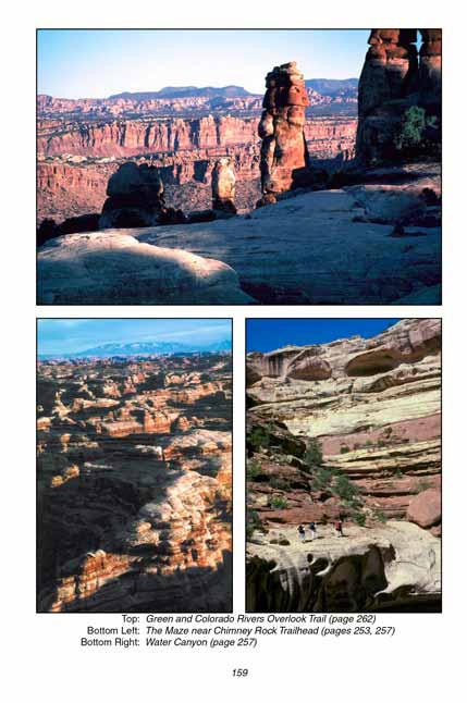
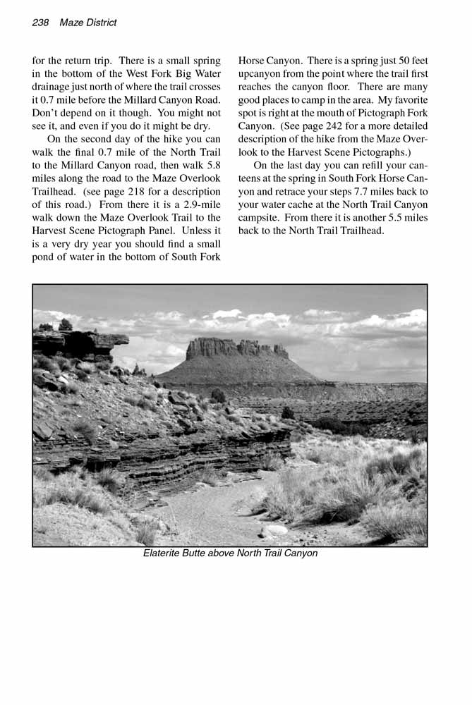
The large picturesque butte in front of you is Elaterite Butte on the east side of Elaterite Basin. You will be walking towards this butte for almost the entire length of this hike.
Over the next two miles you can see several seeps in the walls of North Trail Canyon where water oozes out of the mudstone on either side of the drainage.
The water from these seeps is heavily saturated with alkali that leaves an ugly white crust on the ground when it evaporates.
I don’t know what the water tastes like-I am not brave enough to try it-but there is seldom enough to drink anyway.
You will also pass a couple of fence posts where one of the old sheep ranchers must have had a fence across a narrow part of the canyon to corral his animals.
As you enter Elaterite Basin the North Trail Canyon becomes little more than a shallow, sandy desert wash,
and for the last two miles the trail crosses a grassy flat that must have been a wonderful winter grazing pasture for sheep.
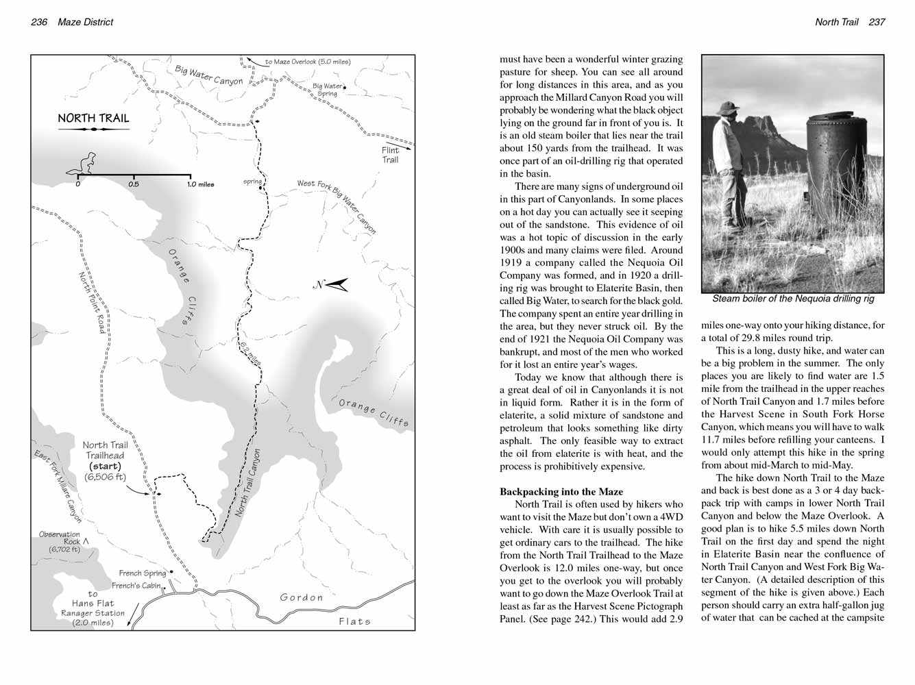
You can see all around for long distances in this area, and as you approach the Millard Canyon Road you will probably be wondering what the black object lying on the ground far in front of you is.
It is an old steam boiler that lies near the trail about 150 yards from the trailhead. It was once part of an oil-drilling rig that operated in the basin.
 There are many signs of underground oil in this part of Canyonlands. In some places on a hot day you can actually see it seeping out of the sandstone.
This evidence of oil was a hot topic of discussion in the early 1900s and many claims were filed.
Around 1919 a company called the Nequoia Oil Company was formed, and in 1920 a drilling rig was brought to Elaterite Basin, then called Big Water, to search for the black gold.
The company spent an entire year drilling in the area, but they never struck oil. By the end of 1921 the Nequoia Oil Company was bankrupt, and most of the men who worked for it lost an entire year’s wages.
There are many signs of underground oil in this part of Canyonlands. In some places on a hot day you can actually see it seeping out of the sandstone.
This evidence of oil was a hot topic of discussion in the early 1900s and many claims were filed.
Around 1919 a company called the Nequoia Oil Company was formed, and in 1920 a drilling rig was brought to Elaterite Basin, then called Big Water, to search for the black gold.
The company spent an entire year drilling in the area, but they never struck oil. By the end of 1921 the Nequoia Oil Company was bankrupt, and most of the men who worked for it lost an entire year’s wages.
Today we know that although there is a great deal of oil in Canyonlands it is not in liquid form.
Rather it is in the form of elaterite, a solid mixture of sandstone and petroleum that looks something like dirty asphalt.
The only feasible way to extract the oil from elaterite is with heat, and the process is prohibitively expensive.
Backpacking into the Maze
North Trail is often used by hikers who want to visit the Maze but don’t own a 4WD vehicle. With care it is usually possible to get ordinary cars to the trailhead.
The hike from the North Trail Trailhead to the Maze Overlook is 12.0 miles one-way,
but once you get to the overlook you will probably want to go down the Maze Overlook Trail at least as far as the Harvest Scene Pictograph Panel.
(See page 242.) This would add 2.9 miles one-way onto your hiking distance, for a total of 29.8 miles round trip.
This is a long, dusty hike, and water can be a big problem in the summer.
The only places you are likely to find water are 1.5 mile from the trailhead in the upper reaches of North Trail Canyon and 1.7 miles before the Harvest Scene in South Fork Horse Canyon,
which means you will have to walk 11.7 miles before refilling your canteens. I would only attempt this hike in the spring from about mid-March to mid-May.
The hike down North Trail to the Maze and back is best done as a 3 or 4 day backpack trip with camps in lower North Trail Canyon and below the Maze Overlook.
A good plan is to hike 5.5 miles down North Trail on the first day and spend the night in Elaterite Basin near the confluence of North Trail Canyon and West Fork Big Water Canyon.
(A detailed description of this segment of the hike is given above.) Each person should carry an extra half-gallon jug of water that can be cached at the campsite for the return trip.
There is a small spring in the bottom of the West Fork Big Water drainage just north of where the trail crosses it 0.7 mile before the Millard Canyon Road. Don’t depend on it though.
You might not see it, and even if you do it might be dry.
On the second day of the hike you can walk the final 0.7 mile of the North Trail to the Millard Canyon road, then walk 5.8 miles along the road to the Maze Overlook Trailhead.
(see page 218 for a description of this road.) From there it is a 2.9-mile walk down the Maze Overlook Trail to the Harvest Scene Pictograph Panel.
Unless it is a very dry year you should find a small pond of water in the bottom of South Fork Horse Canyon.
There is a spring just 50 feet upcanyon from the point where the trail first reaches the canyon floor. There are many good places to camp in the area.
My favorite spot is right at the mouth of Pictograph Fork Canyon. (See page 242 for a more detailed description of the hike from the Maze Overlook to the Harvest Scene Pictographs.)
On the last day you can refill your canteens at the spring in South Fork Horse Canyon and retrace your steps 7.7 miles back to your water cache at the North Trail Canyon campsite.
From there it is another 5.5 miles back to the North Trail Trailhead.
Note to web developers: You may copy this material onto your site, but in return please include a link to my home page
www.utahtrails.com. Thank you, David Day (utahdavidday at gmail.com)
Click here to see more trails in
Canyonlands National Park
© Rincon Publishing Company, all rights reserved
|