Neck Spring Trail
excerpted from our book
Canyonlands National Park
Favorite Jeep Roads & Hiking Trails
pages 40-43
|
Buy book directly from the author!
Canyonlands National Park
Favorite Jeep Roads & Hiking Trails
- has access info for 75 trailheads
- 56 detailed trail maps
- 241 photographs
- loads of driving and hiking tips
|
regularly $14.95
now on sale for only
$11.95
click here
for book orders
|
 The most important natural resource in any desert environment is water, and this is certainly true in Canyonlands National Park. Canyonlands receives
only about nine inches of rain annually, and without springs and seeps the park’s mule deer, coyotes, bobcats, and other large animals could not survive.
The water sources are well known to the animals, and most of them frequent the springs on a daily basis. They come not only for the water itself but
also because of the greater abundance of food nearby.
The most important natural resource in any desert environment is water, and this is certainly true in Canyonlands National Park. Canyonlands receives
only about nine inches of rain annually, and without springs and seeps the park’s mule deer, coyotes, bobcats, and other large animals could not survive.
The water sources are well known to the animals, and most of them frequent the springs on a daily basis. They come not only for the water itself but
also because of the greater abundance of food nearby.
Indians who inhabited Canyonlands as long ago as 8,000 years also depended on springs for their survival. Most of their permanent settlements were
near the Green and Colorado Rivers or in canyons such as Lavender, Horse, or Salt, where there are many reliable springs. But they also spent
considerable time in places like the Island in the Sky, where game is plentiful but water is much harder to find.
This hike passes two important springs at the base of the Navajo Sandstone below the rim of the Island in the Sky Mesa. Don’t expect to find large
amounts of water, though. Cabin Spring, the second one you will see, usually has more water than Neck Spring, but neither of them normally produces
more than a slow trickle of water. The two springs are particularly interesting because they were used extensively by ranchers who worked the area
from about 1880 until 1964, and there are still many artifacts in the area that were left behind by the cowboys. The trail also passes through a
small field of flint chips near Neck Spring-evidence that the area was occupied by prehistoric Indians long before the arrival of the cowboys.
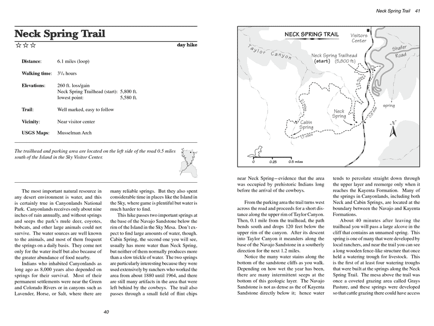
From the parking area the Neck Spring trail turns west across the road and proceeds for a short distance along the upper rim of Taylor Canyon. Then, 0.1 mile
from the trailhead, the path bends south and drops 120 feet below the upper rim of the canyon. After its descent into Taylor Canyon it meanders
along the base of the Navajo Sandstone in a southerly direction for the next 1.2 miles.
Notice the many water stains along the bottom of the sandstone cliffs as you walk. Depending on how wet the year has been, there are many intermittent
seeps at the bottom of this geologic layer. The Navajo Sandstone is not as dense as the of Kayenta Sandstone directly below it; hence water tends
to percolate straight down through the upper layer and reemerge only when it reaches the Kayenta Formation. Many of the springs in Canyonlands,
including both Neck Spring and Cabin Spring, are located at the boundary between the Navajo and Kayenta Formations.
 About 40 minutes after leaving the trailhead you will pass a large alcove in the cliff that contains an unnamed spring.
This spring is one of many that were developed by local ranchers, and near the trail you can see a long wooden fence-like structure that once held a
watering trough for livestock. This is the first of at least four watering troughs that were built at the springs along the Neck Spring Trail.
The mesa above the trail was once a coveted grazing area called Grays Pasture, and these springs were developed so that cattle grazing there could
have access to water.
About 40 minutes after leaving the trailhead you will pass a large alcove in the cliff that contains an unnamed spring.
This spring is one of many that were developed by local ranchers, and near the trail you can see a long wooden fence-like structure that once held a
watering trough for livestock. This is the first of at least four watering troughs that were built at the springs along the Neck Spring Trail.
The mesa above the trail was once a coveted grazing area called Grays Pasture, and these springs were developed so that cattle grazing there could
have access to water.
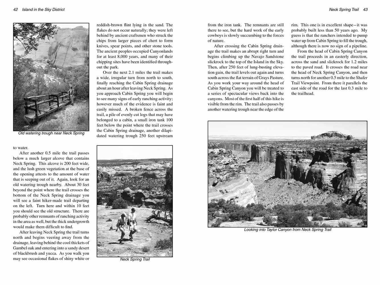
After another 0.5 mile the trail passes below a much larger alcove that contains Neck Spring. This alcove is 200 feet wide, and the lush green
vegetation at the base of the opening attests to the amount of water that is seeping out of it. Again, look for an old watering trough nearby.
About 30 feet beyond the point where the trail crosses the bottom of the Neck Spring drainage you will see a faint hiker-made trail departing
on the left. Turn here and within 10 feet you should see the old structure. There are probably other remnants of ranching activity in the
area as well, but the thick undergrowth would make them difficult to find.
After leaving Neck Spring the trail turns north and begins veering away from the drainage, leaving behind the cool thickets of Gambel oak and
entering into a sandy desert of blackbrush and yucca. As you walk you may see occasional flakes of shiny white or reddish-brown flint lying
in the sand. The flakes do not occur naturally; they were left behind by ancient craftsmen who struck the chips from larger pieces of chert to
form knives, spear points, and other stone tools. The ancient peoples occupied Canyonlands for at least 8,000 years, and many of their chipping
sites have been identified throughout the park.
Over the next 2.1 miles the Neck Spring trail makes a wide, irregular turn from north to south, finally reaching the Cabin Spring drainage about an hour after
leaving Neck Spring. As you approach Cabin Spring you will begin to see many signs of early ranching activity; however much of the evidence is
faint and easily missed. A broken fence across the trail, a pile of evenly cut logs that may have belonged to a cabin, a small iron tank 100
feet below the point where the trail crosses the Cabin Spring drainage, another dilapidated watering trough 250 feet upstream from the iron tank.
The remnants are still there to see, but the hard work of the early cowboys is slowly succumbing to the forces of nature.
After crossing the Cabin Spring drainage the trail makes an abrupt right turn and begins climbing up the Navajo Sandstone slickrock to the top of
the Island in the Sky. Then, after 250 feet of lung-busting elevation gain, the trail levels out again and turns south across the flat terrain of
Grays Pasture. As you work your way around the head of Cabin Spring Canyon you will be treated to a series of spectacular views back into the
canyons. Most of the first half of this hike is visible from the rim. The trail also passes by another watering trough near the edge of the
rim. This one is in excellent shape-it was probably built less than 50 years ago. My guess is that the ranchers intended to pump water up from
Cabin Spring to fill the trough, although there is now no sign of a pipeline.
From the head of Cabin Spring Canyon the trail proceeds in an easterly direction, across the sand and slickrock for 1.2 miles to the paved road.
It crosses the road near the head of Neck Spring Canyon, and then turns north for another 0.5 mile to the Shafer Trail Viewpoint. From there it
parallels the east side of the road for the last 0.3 mile to the trailhead.
Note to web developers: You may copy this material onto your site, but in return please include a link to my home page
www.utahtrails.com. Thank you, David Day (utahdavidday at gmail.com)
Click here to see more trails in
Canyonlands National Park
© Rincon Publishing Company, all rights reserved
|