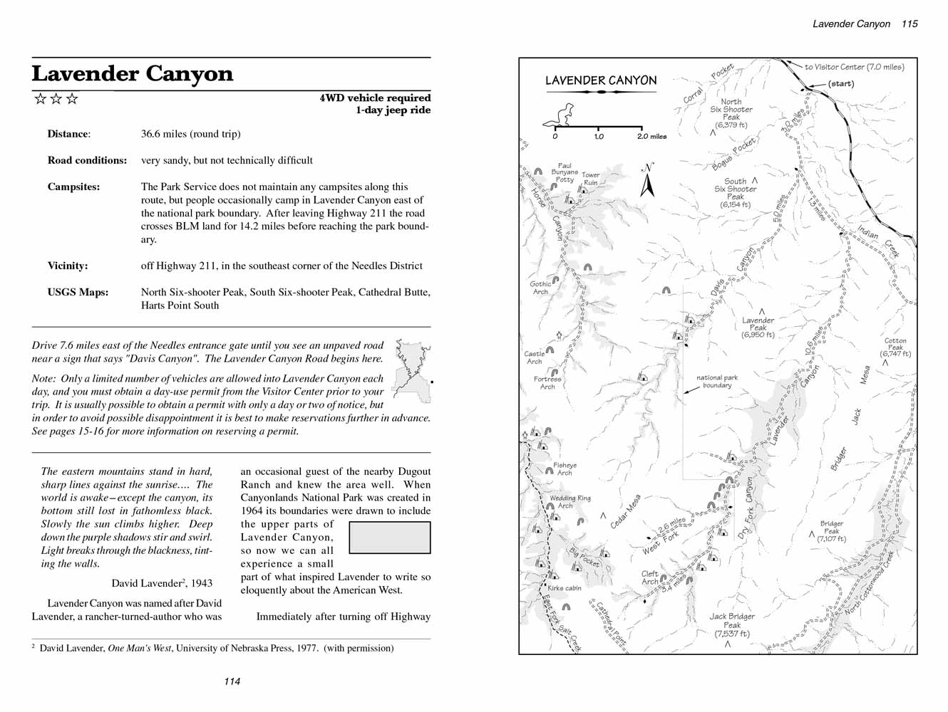
Lavender Canyon
excerpted from our book
Canyonlands National Park
Favorite Jeep Roads & Hiking Trails
pages 114-118
|
Buy book directly from the author!
Canyonlands National Park
Favorite Jeep Roads & Hiking Trails
- has access info for 75 trailheads
- 56 detailed trail maps
- 241 photographs
- loads of driving and hiking tips
|
regularly $14.95
now on sale for only
$11.95
click here
for book orders
|
 The eastern mountains stand in hard, sharp lines against the sunrise…. The world is awake-except the canyon, its bottom still lost in fathomless black.
Slowly the sun climbs higher. Deep down the purple shadows stir and swirl. Light breaks through the blackness, tinting the walls.
The eastern mountains stand in hard, sharp lines against the sunrise…. The world is awake-except the canyon, its bottom still lost in fathomless black.
Slowly the sun climbs higher. Deep down the purple shadows stir and swirl. Light breaks through the blackness, tinting the walls.
David Lavender, 1943
Lavender Canyon was named after David Lavender, a rancher-turned-author who was an occasional guest of the nearby Dugout Ranch and knew the area well.
When Canyonlands National Park was created in 1964 its boundaries were drawn to include the upper parts of Lavender Canyon, so now we can all experience a small part of what inspired Lavender to
write so eloquently about the American West.
Immediately after turning off Highway 211 you will come to an unlocked gate which you must open in order to continue.
Then after another 0.8 mile the road comes to an old corral where it passes through a second gate.
Be sure to close both gates behind you. This section of Lavender Canyon road winds through a wide picturesque valley that is almost completely surrounded by distant cliffs of Wingate Sandstone.
Indian Creek lies beneath the cottonwood trees just east of the road, and the eye-catching landmark two miles to the west is North Six-shooter Peak.
From this angle the butte looks something like a giant anthill with a straw stuck in the top.
1.4 miles after leaving the corral the road drops into Davis Canyon, a shallow, sandy desert wash that at this point hardly deserves to be called a canyon.
The wash is 100 feet wide, with sides that seldom exceed 5 feet in height, and the road proceeds right down the middle.
If there has been a recent rain the sand is usually firm enough for easy driving, but after a few dry weeks the wash quickly turns into a sand trap that you can’t get out of without a 4WD vehicle.
 The road continues down Davis Canyon for just 0.8 mile before coming to another fork where you must bear left to climb out the east side of the wash.
From there it is another 1.3 miles across the flat desert country to Lavender Canyon. Just before reaching Lavender you will enter a grove of large cottonwood trees where there is another fork
in the road. Bear right here, across a cattle guard, and continue in a southwesterly direction through the bottom of the sandy wash.
The road continues down Davis Canyon for just 0.8 mile before coming to another fork where you must bear left to climb out the east side of the wash.
From there it is another 1.3 miles across the flat desert country to Lavender Canyon. Just before reaching Lavender you will enter a grove of large cottonwood trees where there is another fork
in the road. Bear right here, across a cattle guard, and continue in a southwesterly direction through the bottom of the sandy wash.
Like Davis Canyon, Lavender is initially not much of a canyon at all, but rather a shallow, featureless arroyo that meanders across the desert landscape toward the distant highlands.
There is slightly more water in Lavender than Davis, however, and unless you are traveling in the middle of summer you will probably see an intermittent trickle of the life-giving liquid
making its way down- canyon towards Indian Creek.
Finally, about 8.0 miles up Lavender Canyon the streambed starts to cut into the Cedar Mesa Sandstone, and the gulch begins to look more like a real canyon.
Another 0.5 mile will bring you to a major confluence where Dry Fork Canyon enters Lavender from the south.
The sandstone walls on either side of the confluence are about 30 feet high at this point, and the scenery is much more appealing.
There is a short spur road turning into Dry Fork that passes several excellent campsites, but the ravine is too narrow for the road to go far.
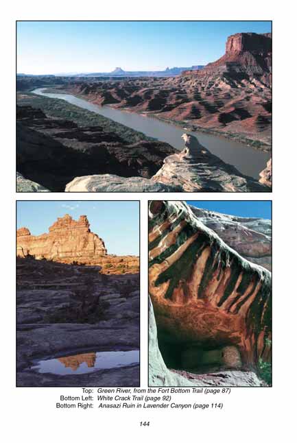
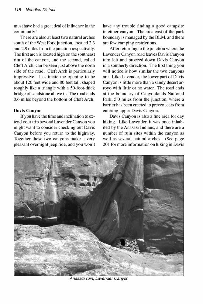
Beyond Dry Fork the road soon enters the most engaging part of Lavender Canyon. The first item of interest is an Anasazi ruin just 1.0 mile beyond the Dry Fork junction.
Turn right onto an obvious side road, and within 200 yards you will see a deep alcove in the sandstone cliff about 30 feet above the canyon floor.
The alcove contains the remains of at least five dwellings. The structures are well protected from the weather in the deep alcove, and must have provided a relatively comfortable shelter
for a family of Indians when the Anasazis occupied this area. The road continues up a minor side canyon for another 0.9 mile beyond the ruin,
but I was unable to spot any more Anasazi sites in the area.
The national park boundary is located 0.6 mile south of the alcove containing the five Anasazi dwellings,
and you will not be able to continue beyond that point unless you have obtained a day-use permit from the visitor center.
There is a locked gate at the boundary, and the combination to the lock is changed daily.
Although camping inside the park boundary is not allowed there are many good campsites just outside the boundary,
and many people choose to spend a night outside the boundary before continuing into the park.
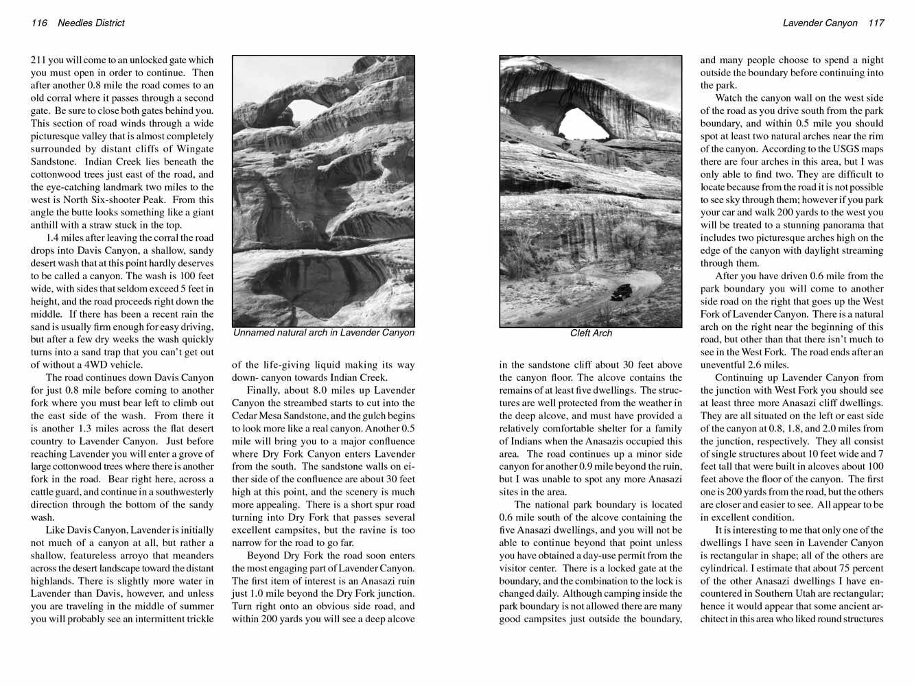
Watch the canyon wall on the west side of the road as you drive south from the park boundary, and within 0.5 mile you should spot at least two natural arches near the rim of the canyon.
According to the USGS maps there are four arches in this area, but I was only able to find two.
They are difficult to locate because from the road it is not possible to see sky through them; however if you park your car and walk 200 yards to the west you will be treated to a stunning
panorama that includes two picturesque arches high on the edge of the canyon with daylight streaming through them.
 After you have driven 0.6 mile from the park boundary you will come to another side road on the right that goes up the West Fork of Lavender Canyon.
There is a natural arch on the right near the beginning of this road, but other than that there isn’t much to see in the West Fork. The road ends after an uneventful 2.6 miles.
After you have driven 0.6 mile from the park boundary you will come to another side road on the right that goes up the West Fork of Lavender Canyon.
There is a natural arch on the right near the beginning of this road, but other than that there isn’t much to see in the West Fork. The road ends after an uneventful 2.6 miles.
Continuing up Lavender Canyon from the junction with West Fork you should see at least three more Anasazi cliff dwellings.
They are all situated on the left or east side of the canyon at 0.8, 1.8, and 2.0 miles from the junction, respectively.
They all consist of single structures about 10 feet wide and 7 feet tall that were built in alcoves about 100 feet above the floor of the canyon.
The first one is 200 yards from the road, but the others are closer and easier to see. All appear to be in excellent condition.
It is interesting to me that only one of the dwellings I have seen in Lavender Canyon is rectangular in shape; all of the others are cylindrical.
I estimate that about 75 percent of the other Anasazi dwellings I have encountered in Southern Utah are rectangular;
hence it would appear that some ancient architect in this area who liked round structures must have had a great deal of influence in the community!
There are also at least two natural arches south of the West Fork junction, located 2.3 and 2.9 miles from the junction respectively.
The first arch is located high on the southeast rim of the canyon, and the second, called Cleft Arch, can be seen just above the north side of the road.
Cleft Arch is particularly impressive. I estimate the opening to be about 120 feet wide and 80 feet tall, shaped roughly like a triangle with a 50-foot-thick bridge of sandstone above it.
The road ends 0.6 miles beyond the bottom of Cleft Arch.
Davis Canyon
If you have the time and inclination to extend your trip beyond Lavender Canyon you might want to consider checking out Davis Canyon before you return to the highway.
Together these two canyons make a very pleasant overnight jeep ride, and you won’t have any trouble finding a good campsite in either canyon.
The area east of the park boundary is managed by the BLM, and there are few camping restrictions.
After returning to the junction where the Lavender Canyon road leaves Davis Canyon turn left and proceed down Davis Canyon in a southerly direction.
The first thing you will notice is how similar the two canyons are. Like Lavender, the lower part of Davis Canyon is little more than a sandy desert arroyo with little or no water.
The road ends at the boundary of Canyonlands National Park, 5.0 miles from the junction, where a barrier has been erected to prevent cars from entering upper Davis Canyon.
Davis Canyon is also a fine area for day hiking. Like Lavender, it was once inhabited by the Anasazi Indians, and there are a number of ruin sites within the
canyon as well as several natural arches. (See page 201 for more information on hiking in Davis Canyon.)
Note to web developers: You may copy this material onto your site, but in return please include a link to my home page
www.utahtrails.com. Thank you, David Day (utahdavidday at gmail.com)
Click here to see more trails in
Canyonlands National Park
© Rincon Publishing Company, all rights reserved
|