Land Of Standing Rocks
excerpted from our book
Canyonlands National Park
Favorite Jeep Roads & Hiking Trails
pages 225-233
|
Buy book directly from the author!
Canyonlands National Park
Favorite Jeep Roads & Hiking Trails
- has access info for 75 trailheads
- 56 detailed trail maps
- 241 photographs
- loads of driving and hiking tips
|
regularly $14.95
now on sale for only
$11.95
click here
for book orders
|
 Although the end of the Land of Standing Rocks road is only 51 miles from a paved highway it can take as much as 6 hours of driving to get there.
The first 34 miles, from Highway 95 near Hite to Waterhole Flat, can usually be driven by almost any vehicle, but beyond that point the road is definitely for 4WD vehicles only.
You will probably be stopping frequently to get out and study the road before venturing ahead with your jeep.
Although the end of the Land of Standing Rocks road is only 51 miles from a paved highway it can take as much as 6 hours of driving to get there.
The first 34 miles, from Highway 95 near Hite to Waterhole Flat, can usually be driven by almost any vehicle, but beyond that point the road is definitely for 4WD vehicles only.
You will probably be stopping frequently to get out and study the road before venturing ahead with your jeep.
Most people drive all the way from the highway to Dollhouse Rock at the end of the road
to the Land of Standing Rocks in a single day, but you may want to take two days for the trip.
Long distance driving on 4WD roads is very tiring, and there is so much to see along the way it is a shame to rush.
The Park Service maintains 8 primitive campsites along this route, and the trip will be much more enjoyable if you make use of them.
During the spring and fall seasons the sites are often full, so it is best to plan ahead and make reservations.
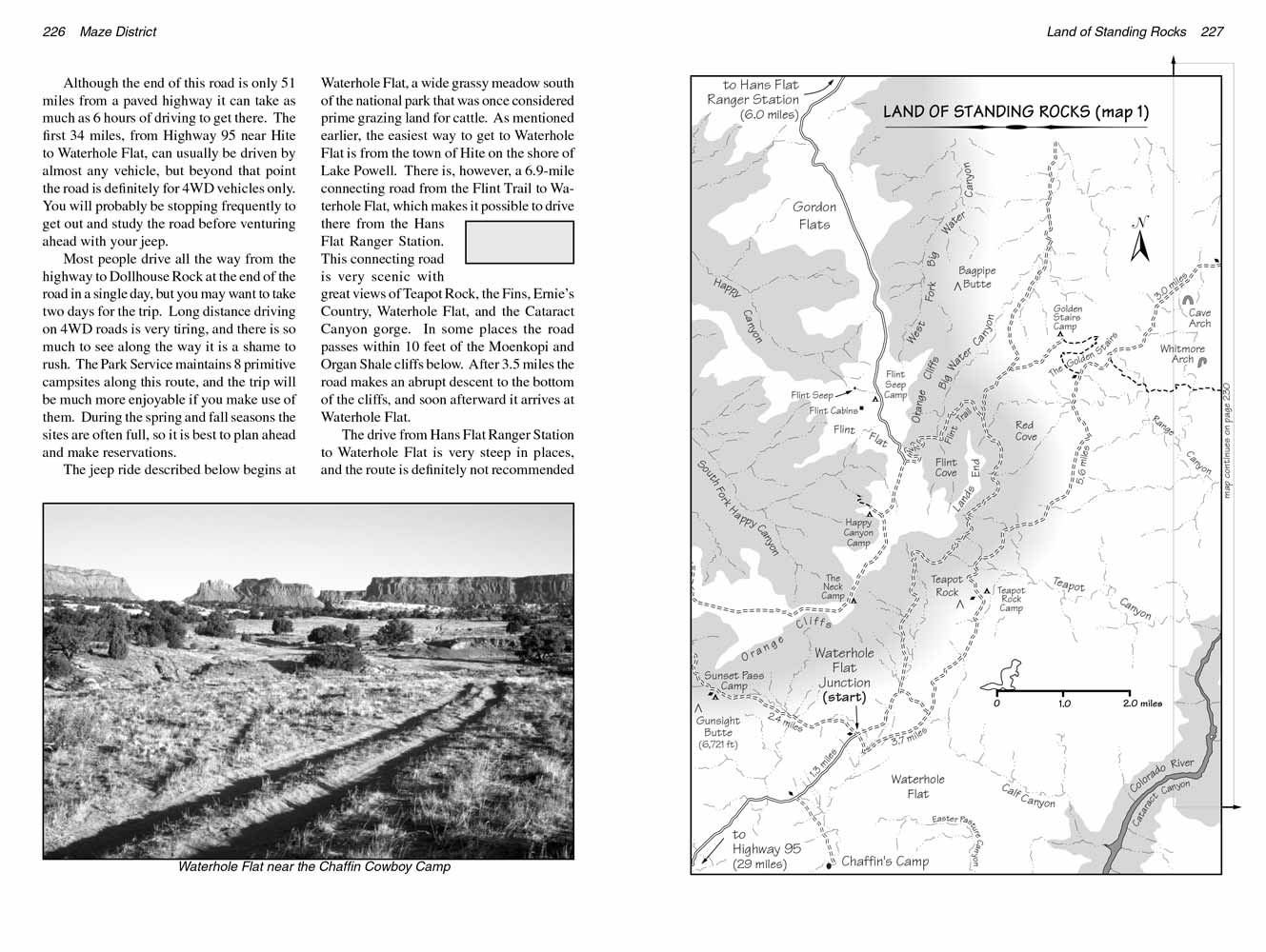
The jeep ride described below begins at Waterhole Flat, a wide grassy meadow south of the national park that was once considered prime grazing land for cattle.
As mentioned earlier, the easiest way to get to Waterhole Flat is from the town of Hite on the shore of Lake Powell.
There is, however, a 6.9-mile connecting road from the Flint Trail to Waterhole Flat, which makes it possible to drive there from the Hans Flat Ranger Station.
This connecting road is very scenic with great views of Teapot Rock, the Fins, Ernie’s Country, Waterhole Flat, and the Cataract Canyon gorge.
In some places the road passes within 10 feet of the Moenkopi and Organ Shale cliffs below.
After 3.5 miles the road makes an abrupt descent to the bottom of the cliffs, and soon afterward it arrives at Waterhole Flat.
The drive from Hans Flat Ranger Station to Waterhole Flat is very steep in places, and the route is definitely not recommended for 2WD vehicles.
Occasionally, however, someone will drive a high-clearance 2WD vehicle down the Flint Trail, across to Waterhole Flat, and on to Hite.
If you don't own a 4WD vehicle this can be an interesting alternative to the trip described below. Just don’t try it in a low-clearance passenger car and don't attempt to do the trip in reverse.
It is probably impossible to get up the Flint Trail with anything less than 4WD.
Sunset Pass Camp and Teapot Rock Camp (3.7 miles)
These two camps are located within a few miles of Waterhole Flat.
In order to reach Sunset Pass Camp you must turn west at Waterhole Flat Junction and drive up the 2WD road to the saddle on the north side of Gunsight Butte.
The camp is located at the summit of the pass 2.4 miles from the junction.
If you happen to be in Waterhole Flat at the end of the day look up toward Sunset Pass and you will see immediately how the pass got its name.
At certain times of the year the sun sets directly behind the opening between Gunsight Butte and the Orange Cliffs.
 The road to Sunset Pass is actually the beginning of a much longer road called the Poison Springs Road.
This is a little used jeep trail that extends all the way from Waterhole Flat, through North Hatch and Hatch Canyons, across the Dirty Devil River, up Poison Springs Canyon, and ultimately back to Highway 95.
The route is extremely rough. It also requires a ford of the Dirty Devil River which is possible only after a long dry spell when the river’s flow rate is lower than normal.
The road to Sunset Pass is actually the beginning of a much longer road called the Poison Springs Road.
This is a little used jeep trail that extends all the way from Waterhole Flat, through North Hatch and Hatch Canyons, across the Dirty Devil River, up Poison Springs Canyon, and ultimately back to Highway 95.
The route is extremely rough. It also requires a ford of the Dirty Devil River which is possible only after a long dry spell when the river’s flow rate is lower than normal.
Before leaving Waterhole Flat you might want to visit the old Chaffin Cowboy Camp.
The Chaffin family ran cows Under the Ledge from 1919 until they sold out in 1944. There were sheep ranchers in the area before that, but their's was the first sizable cattle operation in the Maze District.
They ran their cows in Waterhole Flat, Ernie’s Country and Elaterite Basin, but their operation was mostly centered in Waterhole Flat, and that is where their primary camp was.
There isn’t much left of their camp today but an old corral; however it is still fun to visit.
To get to the Chaffin Camp you must drive back towards Hite from the Waterhole Flat Junction for 1.3 miles until you see a primitive road departing on the left.
Turn here and drive southeast for 1.3 miles, where the road ends at an old stock pond. The Chaffins built the pond simply by making a 150-foot-long dam across the drainage in the upper part of Waterhole Canyon.
150 yards below the dam is an old corral that is still in amazingly good condition.
Their living quarters were a tent cabin that stood about halfway between the corral and the dam on the opposite side of the canyon.
There is nothing left of the cabin now, but you can still see a few relics in the area, including a small trough for collecting water and parts of an old stove.
A cowboy’s life was very simple in those days, supplemented by lots of hard work.
Another 150 yards down the wash from the corral you can see several old names that were scratched into the sandstone long before even the Chaffins were here.
Two of the signatures, Ella Butler and Geo. E. Felton were carved in 1897. To get there walk down the sandy bottom of the wash until you see a small overhang above the low cliffs on the right.
The overhang is 100 feet north of the bottom of Waterhole Canyon, on the east side of a minor side canyon that comes in from the north. The old signatures are on the rock face below the overhang.
 Teapot Rock Camp is located 3.7 miles east of the Waterhole Flat Junction. Turn right at the junction and follow the road marked "Dollhouse".
The road makes a long sweeping turn to the left as it proceeds through the wide, grassy flat, finally heading directly toward Teapot Rock on the northern edge of the meadow.
The camp is located 200 yards east of the base of Teapot Rock, just beyond the point where you can no longer proceed with a 2WD vehicle.
Teapot Rock Camp is located 3.7 miles east of the Waterhole Flat Junction. Turn right at the junction and follow the road marked "Dollhouse".
The road makes a long sweeping turn to the left as it proceeds through the wide, grassy flat, finally heading directly toward Teapot Rock on the northern edge of the meadow.
The camp is located 200 yards east of the base of Teapot Rock, just beyond the point where you can no longer proceed with a 2WD vehicle.
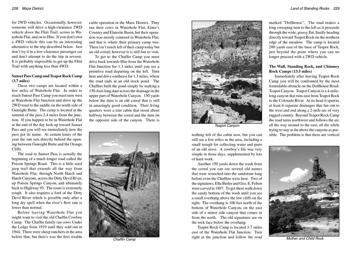
The Wall, Standing Rock, and Chimney Rock Camps (13.5 miles)
Immediately after leaving Teapot Rock Camp you will be confronted by the most formidable obstacle on the
Land of Standing Rocks Road: Teapot Canyon.
Teapot Canyon is a 4-mile-long canyon that runs east from Teapot Rock to the Colorado River.
At its head it spawns at least 6 separate drainages that fan out to the west and end along a 2-mile arc of very rugged country.
Beyond Teapot Rock Camp the road turns northwest and follows the arc all the way around to the east, all the while trying to stay as far above the canyons as possible.
The problem is that there are vertical cliffs northwest of canyon, so there is only a narrow band of land left for road building.
For the next two miles you can expect some very rough driving as the road climbs out of one drainage and drops into another.
5.6 miles after leaving Teapot Rock Camp the road crosses a shallow wash that the Park Service has marked with a large cairn.
This is the lower trailhead for the Golden Stairs Trail (see page 239).
Cattle and sheep ranchers often used this trail in the early 1900s for the purpose of getting their animals from Ernie’s Country and Waterhole Flat to Elaterite Basin.
These three areas were the primary grazing pastures Under the Ledge, and ranchers often drove their animals from one to the other to meet their demands for water and feed.
Today the Golden Stairs Trail is used primarily by hikers who want to get down to Ernie’s Country and The Land of Standing Rocks but don’t have a vehicle that can get across Teapot Canyon.
 Notice the unusual pinnacle of Organ Shale a half-mile in front of the car as you pass the Golden Stairs Trailhead. This 100-foot-high pillar is called the “Mother and Child”.
The reason for the name is not obvious from this perspective, but when you look at it from the north it does look like a mother with a small child clinging to her leg.
When you reach the base of the Mother and Child, 0.8 mile beyond the Golden Stairs Trailhead, you will see a small parking area on the right side of the road that is bordered by a rectangle of stones.
This carpark marks the beginning of the trail into Ernie’s Country. (See page 272 for a description of the Ernie’s Country Trail.)
Notice the unusual pinnacle of Organ Shale a half-mile in front of the car as you pass the Golden Stairs Trailhead. This 100-foot-high pillar is called the “Mother and Child”.
The reason for the name is not obvious from this perspective, but when you look at it from the north it does look like a mother with a small child clinging to her leg.
When you reach the base of the Mother and Child, 0.8 mile beyond the Golden Stairs Trailhead, you will see a small parking area on the right side of the road that is bordered by a rectangle of stones.
This carpark marks the beginning of the trail into Ernie’s Country. (See page 272 for a description of the Ernie’s Country Trail.)
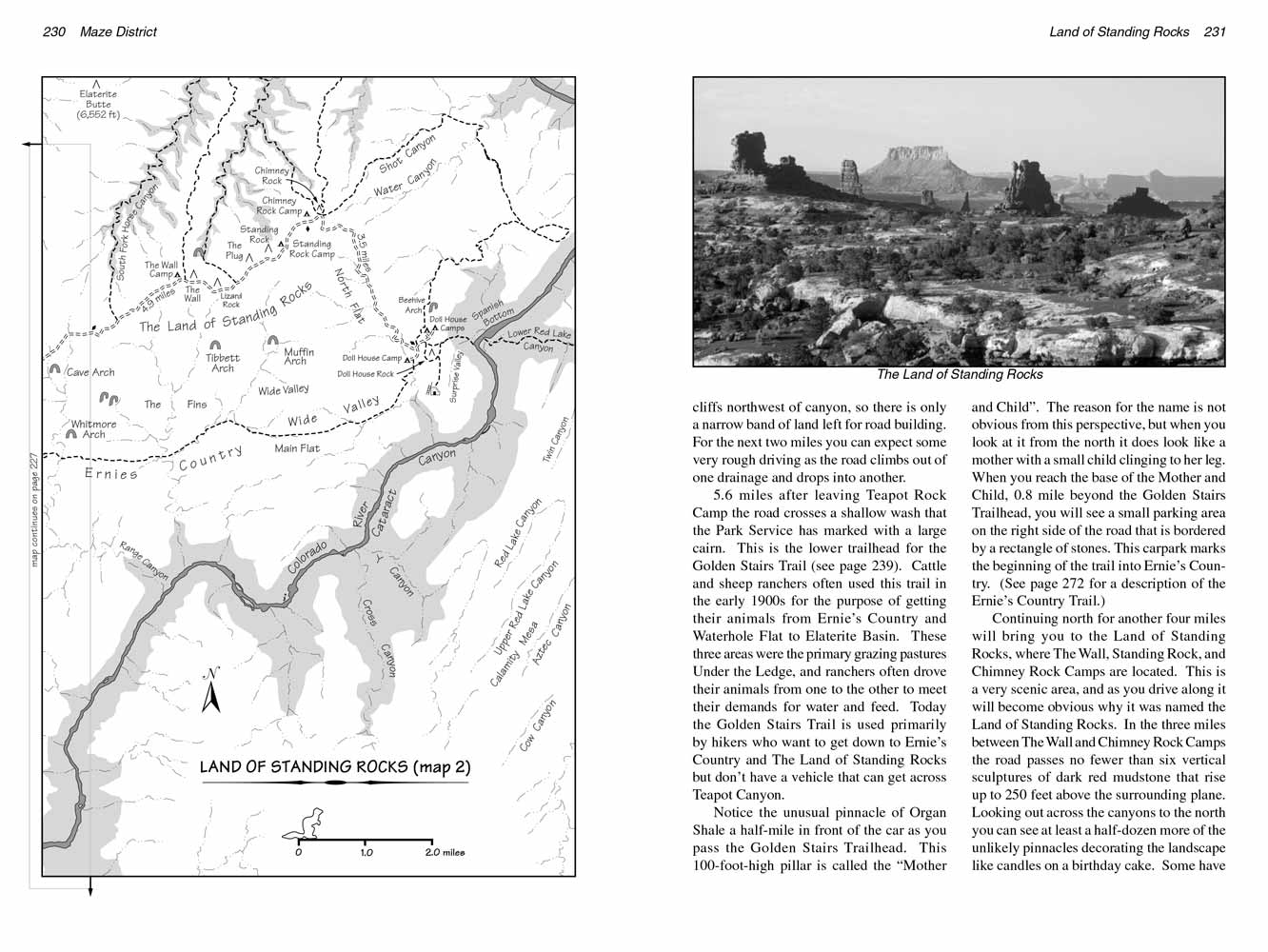
Continuing north for another four miles will bring you to the Land of Standing Rocks, where The Wall, Standing Rock, and Chimney Rock Camps are located.
This is a very scenic area, and as you drive along it will become obvious why it was named the Land of Standing Rocks.
In the three miles between The Wall and Chimney Rock Camps the road passes no fewer than six vertical sculptures of dark red mudstone that rise up to 250 feet above the surrounding plane.
Looking out across the canyons to the north you can see at least a half-dozen more of the unlikely pinnacles decorating the landscape like candles on a birthday cake.
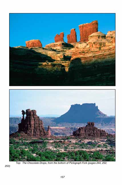
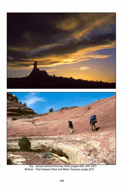
Some have been given whimsical names like Lizard Rock, Chimney Rock, and the Chocolate Drops, but most remain unnamed.
These odd formations are all remnants of the thick strata of rock called the Organ Shale Formation that was deposited in this region some 255 million years ago.
In the last 25-30 million years, since the birth of the Colorado and Green Rivers,
most of the ancient stone near the rivers has been washed away;
however through some quirk of geological fate there still remain in the Land of Standing Rocks a few scattered remnants of the crumbly red Organ Shale.
Probably the best way to see the standing rocks up close is to hike to the Chocolate Drops, an 8.8-mile hike that passes seven of the shale pinnacles.
(See page 251.) The trailhead is located just east of the turnoff to The Wall Camp or 2.0 mile west of the turnoff to the Standing Rock Camp.
In my opinion the best of the three campsites in the Land of Standing Rocks is The Wall, just because it has the best views of the standing rocks north of the road.
The Wall is located 10.6 miles from the Teapot Rock Camp. Chimney Rock Camp is also a favorite because of its proximity to the Chimney Rock Trailhead.
This trailhead is the beginning point for two great loop hikes into the Maze: Pictograph Fork (see page 253), and Shot and Water Canyons (see page 257).
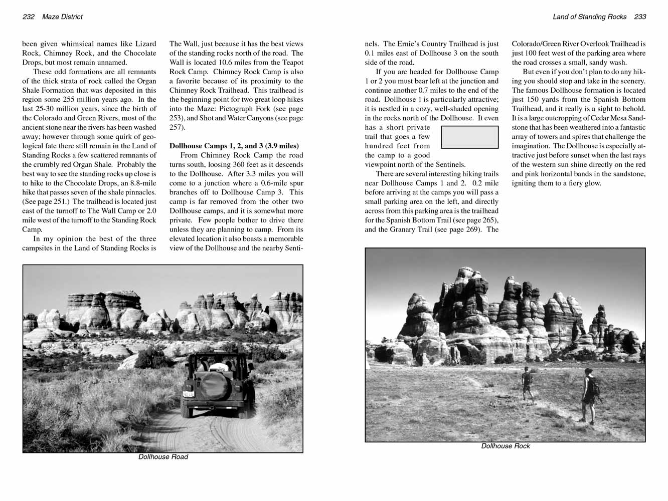 Dollhouse Camps 1, 2, and 3 (3.9 miles)
From Chimney Rock Camp the Land of Standing Rocks road turns south, loosing 360 feet as it descends to the Dollhouse.
After 3.3 miles you will come to a junction where a 0.6-mile spur branches off to Dollhouse Camp 3. This camp is far removed from the other two Dollhouse camps, and it is somewhat more private.
Few people bother to drive there unless they are planning to camp. From its elevated location it also boasts a memorable view of the Dollhouse and the nearby Sentinels.
The Ernie’s Country Trailhead is just 0.1 miles east of Dollhouse 3 on the south side of the road.
If you are headed for Dollhouse Camp 1 or 2 you must bear left at the junction and continue another 0.7 miles to the end of the road.
Dollhouse 1 is particularly attractive; it is nestled in a cozy, well-shaded opening in the rocks north of the Dollhouse.
It even has a short private trail that goes a few hundred feet from the camp to a good viewpoint north of the Sentinels.
There are several interesting hiking trails in the Land
of Standing Rocks near Dollhouse Camps 1 and 2.
0.2 mile before arriving at the camps you will pass a small parking area on the left,
and directly across from this parking area is the trailhead for the Spanish Bottom Trail (see page 265), and the Granary Trail (see page 269).
The Colorado/Green River Overlook Trailhead is just 100 feet west of the parking area where the road crosses a small, sandy wash.
But even if you don’t plan to do any hiking you should stop and take in the scenery
in the Land of Standing Rocks.
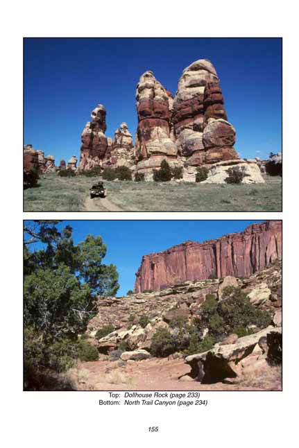
The famous Dollhouse formation is located just 150 yards from the Spanish Bottom Trailhead, and it really is a sight to behold.
It is a large outcropping of Cedar Mesa Sandstone that has been weathered into a fantastic array of towers and spires that challenge the imagination.
The Dollhouse is especially attractive just before sunset when the last rays of the western sun shine directly on the red and pink horizontal bands in the sandstone, igniting them to a fiery glow.
Note to web developers: You may copy this material onto your site, but in return please include a link to my home page
www.utahtrails.com. Thank you, David Day (utahdavidday at gmail.com)
Click here to see more trails in
Canyonlands National Park
© Rincon Publishing Company, all rights reserved
|