Flint Trail-Green River
excerpted from our book
Canyonlands National Park
Favorite Jeep Roads & Hiking Trails
pages 211-224
|
Buy book directly from the author!
Canyonlands National Park
Favorite Jeep Roads & Hiking Trails
- has access info for 75 trailheads
- 56 detailed trail maps
- 241 photographs
- loads of driving and hiking tips
|
regularly $14.95
now on sale for only
$11.95
click here
for book orders
|
 “Under the Ledge” is a term local cowboys once used to identify the canyon country east of the Orange Cliffs in Canyonlands National Park.
The area has subsequently been renamed the Maze District, but this jeep ride will clearly demonstrate how appropriate the older term was.
From Hans Flat Ranger Station the road heads south along the top of the mesa, occasionally approaching the edge of the rim for dramatic views into the canyons below.
Then, after 12.4 miles of relatively easy driving, the road abruptly turns east to descend through a series of steep, rocky switchbacks that lead into the Under the Ledge country.
“Under the Ledge” is a term local cowboys once used to identify the canyon country east of the Orange Cliffs in Canyonlands National Park.
The area has subsequently been renamed the Maze District, but this jeep ride will clearly demonstrate how appropriate the older term was.
From Hans Flat Ranger Station the road heads south along the top of the mesa, occasionally approaching the edge of the rim for dramatic views into the canyons below.
Then, after 12.4 miles of relatively easy driving, the road abruptly turns east to descend through a series of steep, rocky switchbacks that lead into the Under the Ledge country.
This steep section of road, known as the Flint Trail, is the only place where it is possible to descend with a car below the Orange Cliffs.
The trail was well known during most of the last century; it was frequently used by cattle ranchers to gain access to the pastures Under the Ledge.
The Flint Trail was improved enough to accommodate 4WD vehicles during the uranium boom that hit Canyonlands in the early 1950s, but the Park Service has not done much to improve it since then.
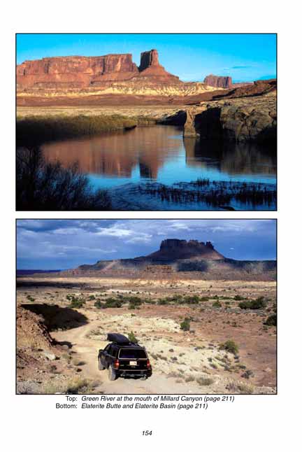
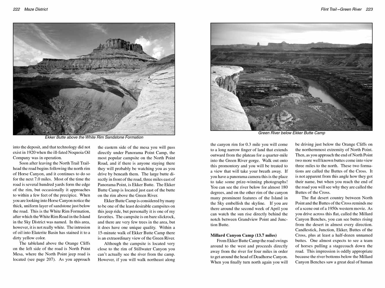
Once below the rim the road turns north to meander across a series of canyons and benches for the next 41 miles before finally ending at the Green River near the mouth of Millard Canyon.
Most of the route is through dry, barren desert country, but the canyons and the buttes provide panoramas that are often breathtaking.
The harshness of the dry, waterless land Under the Ledge may be too alien for some city dwellers to enjoy, but for me the vast land is full of wonder.
The Park Service has established eight primitive campsites along the route described here, and in order to preserve the pristine condition of the land camping is not allowed elsewhere.
The trip could conceivably be done in 2 days with an overnight stay at the Millard Canyon Camp, but I wouldn’t recommend doing it in less than 4 days.
Most people following this route get only as far as the Maze Overlook. There are two very pleasant campsites at the Maze Overlook, and a trip there and back can provide a fine Under the Ledge experience.
However, if time permits I would encourage you to extend your trip an additional 43 miles, round trip, and drive all the way to the Green River.
Flint Seep Camp (11.2 miles)
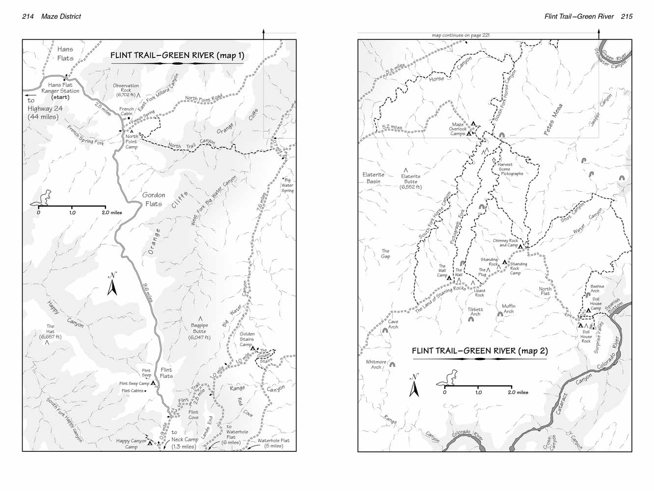
From Hans Flat Ranger Station the road continues in a southeasterly direction across Hans Flat for only 0.9 mile before coming to the first point of interest: the Millard Canyon Overlook.
Look for a sign marking the parking area and the 200-foot trail from the road to the overlook point.
Millard Canyon is a 15-mile-long canyon that extends all the way from Hans Flat to the Green River where this jeep ride ends, and from the overlook you can see about two-thirds of that distance.
Notice the small natural arches about a mile from the viewpoint on the upper west rim of the canyon.
Also Cleopatra’s Chair, a prominent sandstone formation on the east rim of Millard Canyon is clearly visible 6 miles from the viewpoint.
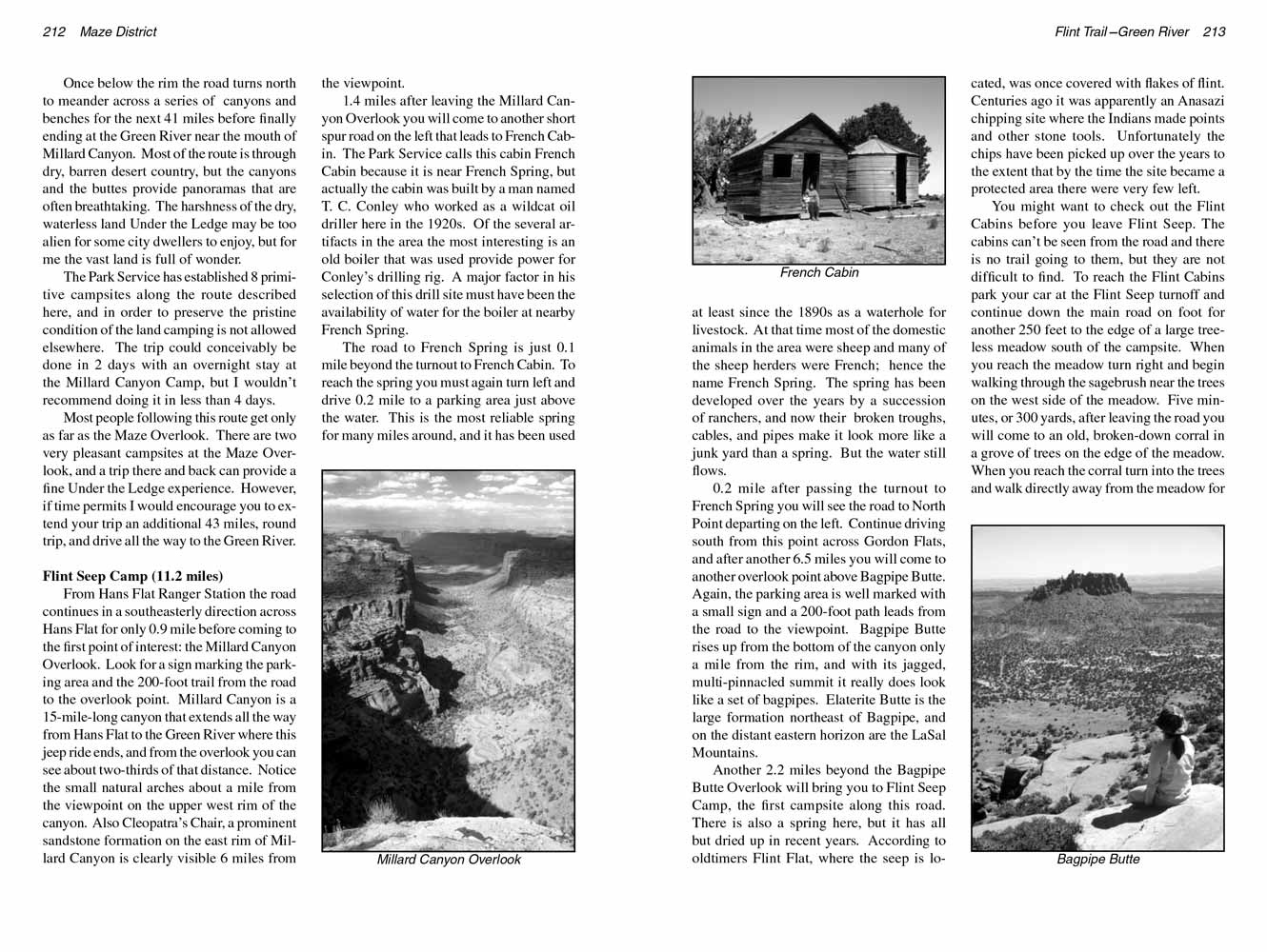
1.4 miles after leaving the Millard Canyon Overlook you will come to another short spur road on the left that leads to French Cabin.
The Park Service calls this cabin French Cabin because it is near French Spring, but actually the cabin was built by a man named T. C. Conley who worked as a wildcat oil driller here in the 1920s.
Of the several artifacts in the area the most interesting is an old boiler that was used provide power for Conley’s drilling rig.
A major factor in his selection of this drill site must have been the availability of water for the boiler at nearby French Spring.
 The road to French Spring is just 0.1 mile beyond the turnout to French Cabin.
To reach the spring you must again turn left and drive 0.2 mile to a parking area just above the water.
This is the most reliable spring for many miles around, and it has been used at least since the 1890s as a waterhole for livestock.
At that time most of the domestic animals in the area were sheep and many of the sheep herders were French; hence the name French Spring.
The spring has been developed over the years by a succession of ranchers, and now their broken troughs, cables, and pipes make it look more like a junk yard than a spring.
But the water still flows.
The road to French Spring is just 0.1 mile beyond the turnout to French Cabin.
To reach the spring you must again turn left and drive 0.2 mile to a parking area just above the water.
This is the most reliable spring for many miles around, and it has been used at least since the 1890s as a waterhole for livestock.
At that time most of the domestic animals in the area were sheep and many of the sheep herders were French; hence the name French Spring.
The spring has been developed over the years by a succession of ranchers, and now their broken troughs, cables, and pipes make it look more like a junk yard than a spring.
But the water still flows.
0.2 mile after passing the turnout to French Spring you will see the road to North Point departing on the left.
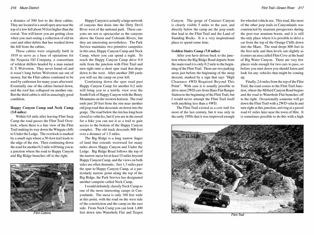
Continue driving south from this point across Gordon Flats, and after another 6.5 miles you will come to another overlook point above Bagpipe Butte.
Again, the parking area is well marked with a small sign and a 200-foot path leads from the road to the viewpoint.
Bagpipe Butte rises up from the bottom of the canyon only a mile from the rim, and with its jagged, multi-pinnacled summit it really does look like a set of bagpipes.
Elaterite Butte is the large formation northeast of Bagpipe, and on the distant eastern horizon are the LaSal Mountains.
Another 2.2 miles beyond the Bagpipe Butte Overlook will bring you to Flint Seep Camp, the first campsite along this road.
There is also a spring here, but it has all but dried up in recent years. According to oldtimers Flint Flat, where the seep is located, was once covered with flakes of flint.
Centuries ago it was apparently an Anasazi chipping site where the Indians made points and other stone tools.
Unfortunately the chips have been picked up over the years to the extent that by the time the site became a protected area there were very few left.
You might want to check out the Flint Cabins before you leave Flint Seep. The cabins can’t be seen from the road and there is no trail going to them, but they are not difficult to find.
To reach the Flint Cabins park your car at the Flint Seep turnoff and continue down the main road on foot for another 250 feet to the edge of a large treeless meadow south of the campsite.
When you reach the meadow turn right and begin walking through the sagebrush near the trees on the west side of the meadow.
Five minutes, or 300 yards, after leaving the road you will come to an old, broken-down corral in a grove of trees on the edge of the meadow.
When you reach the corral turn into the trees and walk directly away from the meadow for a distance of 500 feet to the three cabins.
They are located in a small open area near the top of a low hill about 50 feet higher than the corral.
You will know you are getting close when you start seeing a collection of old tin cans and other debris that has washed down the hill from the cabins.
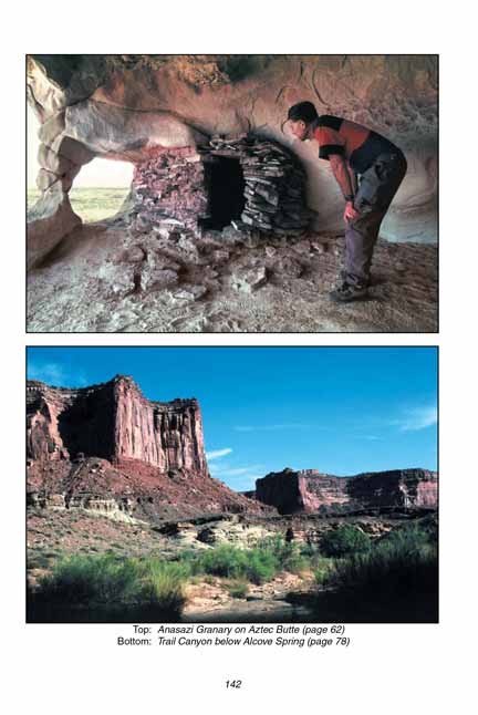
 These cabins were originally built in 1919 to serve as a base of operations for the Nequoia Oil Company, a consortium of wildcat drillers headed by a man named E. T. Wolverton.
They never found oil and it wasn’t long before Wolverton ran out of money, but the Flint cabins continued to be used by cattlemen for many years afterward.
Eventually one of the cabins burned down, and the roof has collapsed on another one. But the third cabin is still in amazingly good condition.
These cabins were originally built in 1919 to serve as a base of operations for the Nequoia Oil Company, a consortium of wildcat drillers headed by a man named E. T. Wolverton.
They never found oil and it wasn’t long before Wolverton ran out of money, but the Flint cabins continued to be used by cattlemen for many years afterward.
Eventually one of the cabins burned down, and the roof has collapsed on another one. But the third cabin is still in amazingly good condition.
Happy Canyon Camp and Neck Camp (3.8 miles)
Within 0.8 mile after leaving Flint Seep Camp the road passes the Flint Trail Overlook, where there is a fine view of the Flint Trail making its way down the Wingate cliffs to Under the Ledge.
The overlook is marked by a small sign where a 50-foot trail leads to the edge of the rim.
Then continuing down the road for another 0.2 mile will bring you to a junction where the road to Happy Canyon and Big Ridge branches off to the right.
Happy Canyon is actually a large network of canyons that drain into the Dirty Devil River west of the national park.
These canyons are not as spectacular as the canyons above the Green and Colorado Rivers, but they are interesting nevertheless.
The Park Service maintains two primitive campsites in this area, Happy Canyon Camp and Neck Camp, where you can spend a night.
To reach the Happy Canyon Camp drive 0.9 mile from the junction with Flint Trail and turn right onto a short spur road that drops down to the west.
After another 200 yards you will see the camp on your left.
Continuing down the spur road past Happy Canyon Camp for another 0.2 mile will bring you to a terrific view over the South Fork of Happy Canyon with the Henry Mountains on the western horizon.
The road ends just 20 feet from the rim near another old jeep road that descends on down into the gorge.
The road below the rim has long been closed to vehicles, but if you are in the mood for a hike you can use it as a trail to gain access to the bottom of the Happy Canyon complex.
The old track descends 800 feet over a distance of 1.5 miles.
The Big Ridge is a long narrow finger of land that extends westward for many miles above Happy Canyon and Under the Ledge.
Big Ridge Road follows the top of the narrow mesa for at least 15 miles beyond Happy Canyon Camp, and the views on both sides are often dramatic.
Just 1.3 miles past the spur to Happy Canyon Camp, at a particularly narrow point along the top of the Big Ridge, the Park Service has designated another campsite called Neck Camp.
I would definitely classify Neck Camp as one of the more interesting camps in Canyonlands.
The mesa is only 100 feet wide at this point, with the road on the west side of the constriction and the camp on the east side.
From Neck Camp you can look 1,400 feet down into Waterhole Flat and Teapot Canyon.
The gorge of Cataract Canyon is clearly visible 5 miles to the east, and directly below the camp are the jeep roads that lead to the Flint Trail and the Land of Standing Rocks.
It is a very inspirational place to spend some time.
 Golden Stairs Camp (7.0 miles)
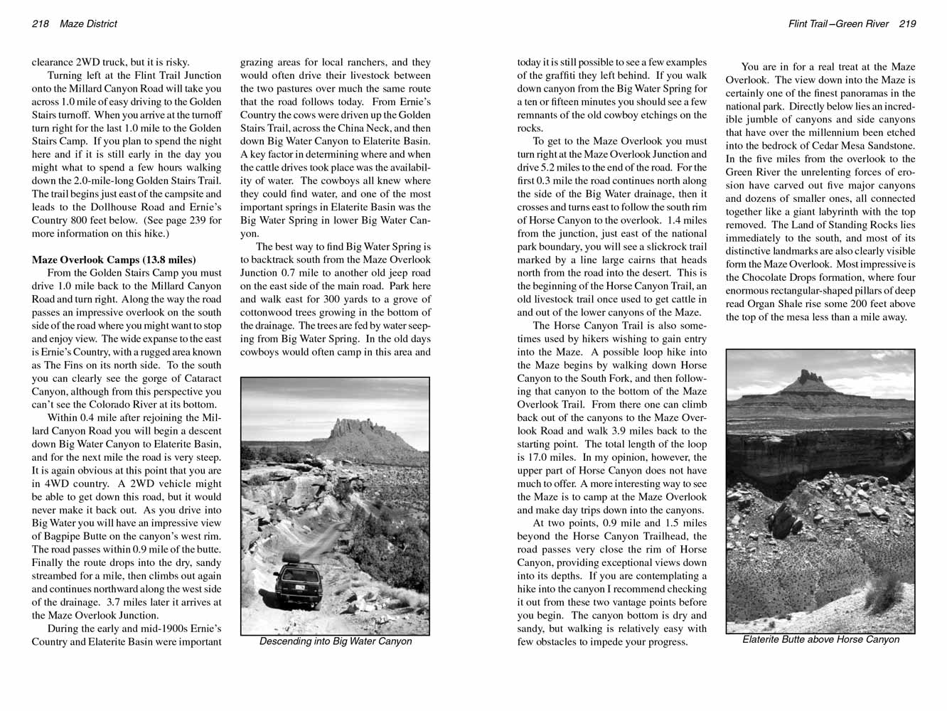
After you have driven back to the junction where the Big Ridge Road departs from the main road it is only 0.2 mile to the beginning of the Flint Trail.
There are two parking areas just before the beginning of the steep descent, marked by a sign that says "High Clearance 4WD Required Beyond This Point".
With care it is usually possible to drive most 2WD cars from Hans Flat Ranger Station to the beginning of the Flint Trail, but I would never attempt the Flint Trail itself with anything less than a 4WD.
The Flint Trail existed as a cow trail for most of the last century, but it was only in the early 1950s that it was improved enough for wheeled vehicle use.
This road, like most of the other jeep trails in Canyonlands was constructed by uranium prospectors during the post-war uranium boom,
and it is still the only place where it is possible to drive a car from the top of the Orange Cliffs down into the Maze.
The road drops 800 feet in the first mile and then levels out slightly as it enters an area called Flint Cove at the head of Big Water Canyon.
There are very few places wide enough for two cars to pass, so before you start down you should listen and look for any vehicles that might be coming up.
Finally, 2.6 miles from the top of the Flint Trail, the road comes to the Flint Trail Junction, where the Millard Canyon Road begins and the road to Waterhole Flat branches off to the right.
Occasionally someone will go down the Flint Trail with a 2WD vehicle and turn right at this junction, arriving at a paved road 41 miles later near the town of Hite.
It is sometimes possible to do this with a high clearance 2WD truck, but it is risky.
Turning left at the Flint Trail Junction onto the Millard Canyon Road will take you across 1.0 mile of easy driving to the Golden Stairs turnoff.
When you arrive at the turnoff turn right for the last 1.0 mile to the Golden Stairs Camp.
If you plan to spend the night here and if it is still early in the day you might what to spend a few hours walking down the 2.0-mile-long Golden Stairs Trail.
The trail begins just east of the campsite and leads to the Dollhouse Road and Ernie’s Country 800 feet below. (See page 239 for more information on this hike.)
 Maze Overlook Camps (13.8 miles)
From the Golden Stairs Camp you must drive 1.0 mile back to the Millard Canyon Road and turn right.
Along the way the road passes an impressive overlook on the south side of the road where you might want to stop and enjoy view.
The wide expanse to the east is Ernie’s Country, with a rugged area known as The Fins on its north side.
To the south you can clearly see the gorge of Cataract Canyon, although from this perspective you can’t see the Colorado River at its bottom.
Within 0.4 mile after rejoining the Millard Canyon Road you will begin a descent down Big Water Canyon to Elaterite Basin, and for the next mile the road is very steep.
It is again obvious at this point that you are in 4WD country.
A 2WD vehicle might be able to get down this road, but it would never make it back out. As you drive into Big Water you will have an impressive view of Bagpipe Butte on the canyon’s west rim.
The road passes within 0.9 mile of the butte. Finally the route drops into the dry, sandy streambed for a mile, then climbs out again and continues northward along the west side of the drainage.
3.7 miles later it arrives at the Maze Overlook Junction.
During the early and mid-1900s Ernie’s Country and Elaterite Basin were important grazing areas for local ranchers,
and they would often drive their livestock between the two pastures over much the same route that the road follows today.
From Ernie’s Country the cows were driven up the Golden Stairs Trail, across the China Neck, and then down Big Water Canyon to Elaterite Basin.
A key factor in determining where and when the cattle drives took place was the availability of water.
The cowboys all knew where they could find water, and one of the most important springs in Elaterite Basin was the Big Water Spring in lower Big Water Canyon.
The best way to find Big Water Spring is to backtrack south from the Maze Overlook Junction 0.7 mile to another old jeep road on the east side of the main road.
Park here and walk east for 300 yards to a grove of cottonwood trees growing in the bottom of the drainage. The trees are fed by water seeping from Big Water Spring.
In the old days cowboys would often camp in this area and today it is still possible to see a few examples of the graffiti they left behind.
If you walk down canyon from the Big Water Spring for a ten or fifteen minutes you should see a few remnants of the old cowboy etchings on the rocks.
To get to the Maze Overlook you must turn right at the Maze Overlook Junction and drive 5.2 miles to the end of the road.
For the first 0.3 mile the road continues north along the side of the Big Water drainage, then it crosses and turns east to follow the south rim of Horse Canyon to the overlook.
1.4 miles from the junction, just east of the national park boundary, you will see a slickrock trail marked by a line large cairns that heads north from the road into the desert.
This is the beginning of the Horse Canyon Trail, an old livestock trail once used to get cattle in and out of the lower canyons of the Maze.
 The Horse Canyon Trail is also sometimes used by hikers wishing to gain entry into the Maze.
A possible loop hike into the Maze begins by walking down Horse Canyon to the South Fork, and then following that canyon to the bottom of the Maze Overlook Trail.
From there one can climb back out of the canyons to the Maze Overlook Road and walk 3.9 miles back to the starting point. The total length of the loop is 17.0 miles.
In my opinion, however, the upper part of Horse Canyon does not have much to offer. A more interesting way to see the Maze is to camp at the Maze Overlook and make day trips down into the canyons.
The Horse Canyon Trail is also sometimes used by hikers wishing to gain entry into the Maze.
A possible loop hike into the Maze begins by walking down Horse Canyon to the South Fork, and then following that canyon to the bottom of the Maze Overlook Trail.
From there one can climb back out of the canyons to the Maze Overlook Road and walk 3.9 miles back to the starting point. The total length of the loop is 17.0 miles.
In my opinion, however, the upper part of Horse Canyon does not have much to offer. A more interesting way to see the Maze is to camp at the Maze Overlook and make day trips down into the canyons.
At two points, 0.9 mile and 1.5 miles beyond the Horse Canyon Trailhead, the road passes very close the rim of Horse Canyon, providing exceptional views down into its depths.
If you are contemplating a hike into the canyon I recommend checking it out from these two vantage points before you begin.
The canyon bottom is dry and sandy, but walking is relatively easy with few obstacles to impede your progress.
You are in for a real treat at the Maze Overlook. The view down into the Maze is certainly one of the finest panoramas in the national park.
Directly below lies an incredible jumble of canyons and side canyons that have over the millennium been etched into the bedrock of Cedar Mesa Sandstone.
In the five miles from the overlook to the Green River the unrelenting forces of erosion have carved out five major canyons and dozens of smaller ones,
all connected together like a giant labyrinth with the top removed. The Land of Standing Rocks lies immediately to the south, and most of its distinctive landmarks are also clearly visible form the Maze Overlook.
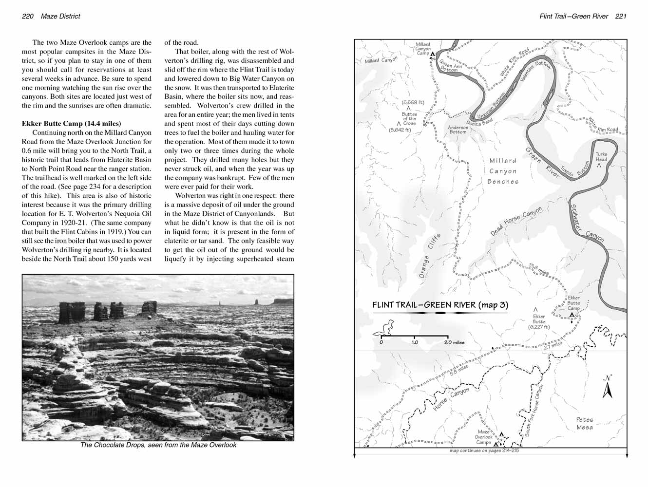
Most impressive is the Chocolate Drops formation, where four enormous rectangular-shaped pillars of deep red Organ Shale rise some 200 feet above the top of the mesa less than a mile away.
The two Maze Overlook camps are the most popular campsites in the Maze District, so if you plan to stay in one of them you should call for reservations at least several weeks in advance.
Be sure to spend one morning watching the sun rise over the canyons. Both sites are located just west of the rim and the sunrises are often dramatic.
Ekker Butte Camp (14.4 miles)
Continuing north on the Millard Canyon Road from the Maze Overlook Junction for 0.6 mile will bring you to the North Trail,
a historic trail that leads from Elaterite Basin to North Point Road near the ranger station. The trailhead is well marked on the left side of the road.
(See page 234 for a description of this hike). This area is also of historic interest because it was the primary drilling location for E. T. Wolverton’s Nequoia Oil Company in 1920-21.
(The same company that built the Flint Cabins in 1919.) You can still see the iron boiler that was used to power Wolverton’s drilling rig nearby.
It is located beside the North Trail about 150 yards west of the road.
 That boiler, along with the rest of Wolverton’s drilling rig, was disassembled and slid off the rim where the Flint Trail is today and lowered down to Big Water Canyon on the snow.
It was then transported to Elaterite Basin, where the boiler sits now, and reassembled.
Wolverton’s crew drilled in the area for an entire year; the men lived in tents and spent most of their days cutting down trees to fuel the boiler and hauling water for the operation.
Most of them made it to town only two or three times during the whole project. They drilled many holes but they never struck oil, and when the year was up the company was bankrupt.
Few of the men were ever paid for their work.
That boiler, along with the rest of Wolverton’s drilling rig, was disassembled and slid off the rim where the Flint Trail is today and lowered down to Big Water Canyon on the snow.
It was then transported to Elaterite Basin, where the boiler sits now, and reassembled.
Wolverton’s crew drilled in the area for an entire year; the men lived in tents and spent most of their days cutting down trees to fuel the boiler and hauling water for the operation.
Most of them made it to town only two or three times during the whole project. They drilled many holes but they never struck oil, and when the year was up the company was bankrupt.
Few of the men were ever paid for their work.
Wolverton was right in one respect: there is a massive deposit of oil under the ground in the Maze District of Canyonlands.
But what he didn’t know is that the oil is not in liquid form; it is present in the form of elaterite or tar sand.
The only feasible way to get the oil out of the ground would be liquefy it by injecting superheated steam into the deposit,
and that technology did not exist in 1920 when the ill-fated Noquoia Oil Company was in operation.
Soon after leaving the North Trail Trailhead the road begins following the north rim of Horse Canyon, and it continues to do so for the next 7.0 miles.
Most of the time the road is several hundred yards form the edge of the rim, but occasionally it approaches to within a few feet of the precipice.
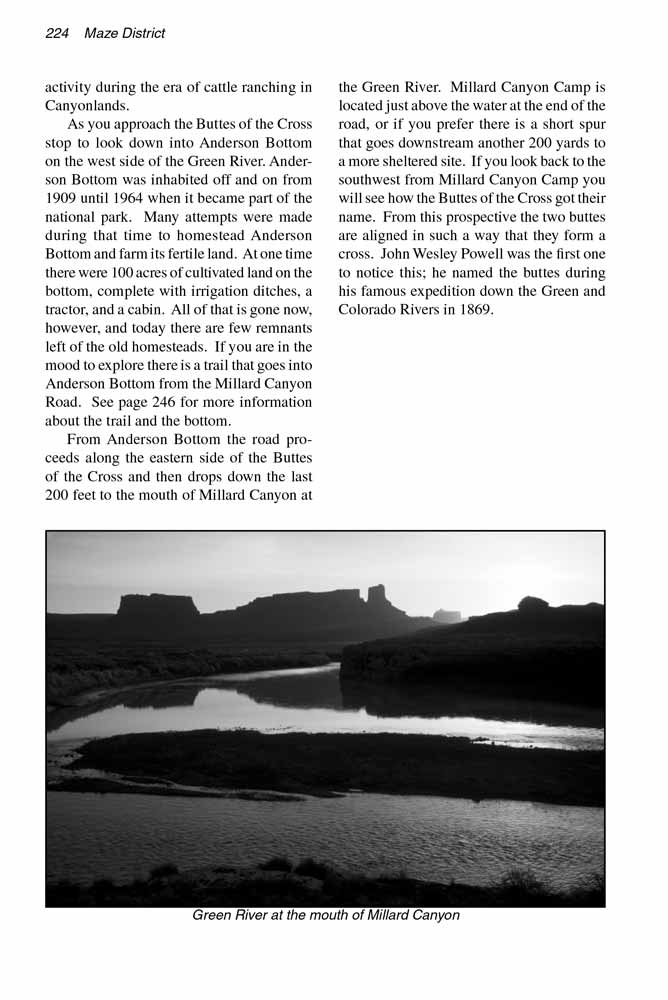
When you are looking into Horse Canyon notice the thick, uniform layer of sandstone just below the road. This is the White Rim Formation, after which the White Rim Road in the Island in the Sky District was named.
In this area, however, it is not really white. The intrusion of oil into Elaterite Basin has stained it to a dirty yellow color.
 The tableland above the Orange Cliffs on the left side of the road is North Point Mesa, where the North Point jeep road is located (see page 207).
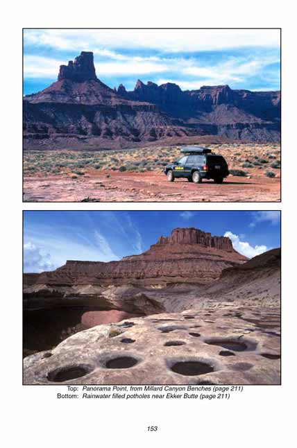
As you approach the eastern side of the mesa you will pass directly under Panorama Point Camp, the most popular campsite on the North Point Road,
and if there is anyone staying there they will probably be watching you as you drive by beneath them.
The large butte directly in front of the road, three miles east of Panorama Point, is Ekker Butte.
The Ekker Butte Camp is located just east of the butte on the rim above the Green River.
The tableland above the Orange Cliffs on the left side of the road is North Point Mesa, where the North Point jeep road is located (see page 207).
As you approach the eastern side of the mesa you will pass directly under Panorama Point Camp, the most popular campsite on the North Point Road,
and if there is anyone staying there they will probably be watching you as you drive by beneath them.
The large butte directly in front of the road, three miles east of Panorama Point, is Ekker Butte.
The Ekker Butte Camp is located just east of the butte on the rim above the Green River.
Ekker Butte Camp is considered by many to be one of the least desirable campsites on this jeep ride, but personally it is one of my favorites.
The campsite is on bare slickrock, and there are very few trees in the area, but it does have one unique quality.
Within a 15-minute walk of Ekker Butte Camp there is an extraordinary view of the Green River.
Although the campsite is located very close to the rim of Stillwater Canyon you can’t actually see the river from the camp.
However, if you will walk northeast along the canyon rim for 0.3 mile you will come to a long narrow finger of land that extends outward from the plateau for a quarter-mile into the Green River gorge.
Walk out onto this promontory and you will be treated to a view that will take your breath away.
If you have a panorama camera this is the place to take some prize-winning photographs!
You can see the river below for almost 180 degrees, and on the other rim of the canyon many prominent features of the Island in the Sky embellish the skyline.
If you are there around the second week of April you can watch the sun rise directly behind the notch between Grandview Point and Junction Butte.
Millard Canyon Camp (13.7 miles)
From Ekker Butte Camp the road swings around to the west and proceeds directly away from the river for four miles in order to get around the head of Deadhorse Canyon.
When you finally turn north again you will be driving just below the Orange Cliffs on the northernmost extremity of North Point.
Then, as you approach the end of North Point two more well known buttes come into view three miles to the north. These two formations are called the Buttes of the Cross.
It is not apparent from this angle how they got their name, but when you reach the end of the road you will see why they are called the Buttes of the Cross.
The flat desert country between North Point and the Buttes of the Cross reminds me of a scene out of a 1950s western movie.
As you drive across this flat, called the Millard Canyon Benches, you can see buttes rising from the desert in almost every direction.
Candlestick, Junction, Ekker, Buttes of the Cross, plus at least a half-dozen unnamed buttes. One almost expects to see a team of horses pulling a stagecoach down the road.
This impression is oddly appropriate because the river bottoms below the Millard Canyon Benches saw a great deal of human activity during the era of cattle ranching in Canyonlands.
As you approach the Buttes of the Cross stop to look down into Anderson Bottom on the west side of the Green River.
Anderson Bottom was inhabited off and on from 1909 until 1964 when it became part of the national park. Many attempts were made during that time to homestead Anderson Bottom and farm its fertile land.
At one time there were 100 acres of cultivated land on the bottom, complete with irrigation ditches, a tractor, and a cabin.
All of that is gone now, however, and today there are few remnants left of the old homesteads. If you are in the mood to explore there is a trail that goes into Anderson Bottom from the Millard Canyon Road.
See page 246 for more information about the trail and the bottom.
From Anderson Bottom the road proceeds along the eastern side of the Buttes of the Cross and then drops down the last 200 feet to the mouth of Millard Canyon at the Green River.
Millard Canyon Camp is located just above the water at the end of the road, or if you prefer there is a short spur that goes downstream another 200 yards to a more sheltered site.
If you look back to the southwest from Millard Canyon Camp you will see how the Buttes of the Cross got their name. From this prospective the two buttes are aligned in such a way that they form a cross.
John Wesley Powell was the first one to notice this; he named the buttes during his famous expedition down the Green and Colorado Rivers in 1869.
Note to web developers: You may copy this material onto your site, but in return please include a link to my home page
www.utahtrails.com. Thank you, David Day (utahdavidday at gmail.com)
Click here to see more trails in
Canyonlands National Park
© Rincon Publishing Company, all rights reserved
|