Elephant Hill Road
excerpted from our book
Canyonlands National Park
Favorite Jeep Roads & Hiking Trails
pages 103-108
|
Buy book directly from the author!
Canyonlands National Park
Favorite Jeep Roads & Hiking Trails
- has access info for 75 trailheads
- 56 detailed trail maps
- 241 photographs
- loads of driving and hiking tips
|
regularly $14.95
now on sale for only
$11.95
click here
for book orders
|
 The road over Elephant Hill is, in my opinion, the most challenging jeep road in Canyonlands National Park. It presents drivers
with a series of obstacles ranging from loose rock and stairstep drops to steep grades with hairpin turns. One of the turns is so tight that most
vehicles must back down the succeeding switchback. With skill, however, the road can be negotiated with an ordinary 4WD vehicle-I have driven my
Jeep Cherokee over Elephant Hill many times. The park service has even poured concrete in a few critical places to make the road passable for stock
vehicles, but it is still a difficult road.
The road over Elephant Hill is, in my opinion, the most challenging jeep road in Canyonlands National Park. It presents drivers
with a series of obstacles ranging from loose rock and stairstep drops to steep grades with hairpin turns. One of the turns is so tight that most
vehicles must back down the succeeding switchback. With skill, however, the road can be negotiated with an ordinary 4WD vehicle-I have driven my
Jeep Cherokee over Elephant Hill many times. The park service has even poured concrete in a few critical places to make the road passable for stock
vehicles, but it is still a difficult road.
The road over Elephant Hill Road was originally built in the early 1940s by a man named Puge Stocks, a bulldozer operator who was working at the
time for the Dugout Ranch. Cattle had been grazed in the Needles area since the 1800s, but the road greatly facilitated the enterprise. Several
small airstrips were also built in the area after the road was finished so light airplanes could service the ranching operations. Although it is
not visible today, one of the runways was near the road on the top of Elephant Hill!
The basic loop described below is only 9.4 miles long and will take most drivers less than three hours to complete. However there is a great deal
to see beyond Elephant Hill, and, for the most part, once you are past the first 3.5 miles the roads are much better. It would be a shame not to
enjoy the fruits of your efforts (and your car’s!) for a day or two before returning to the pavement. If you want to check out the remaining 21
miles of jeep roads east of Elephant Hill or perhaps go on one of the hiking trails I suggest you spend a night in one of the Park Service’s
campgrounds. The best 4 campsites are at Devils Kitchen, but there are also 4 other sites to choose from.
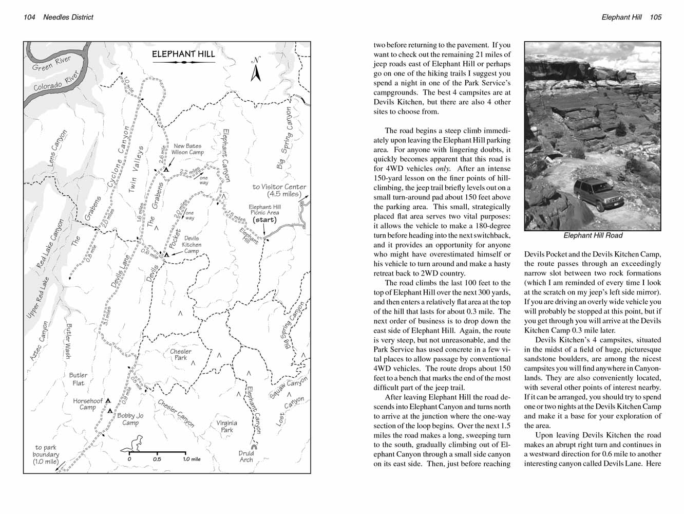
The Elephant Hill road begins a steep climb immediately upon leaving the Elephant Hill parking area. For anyone with lingering doubts, it quickly becomes apparent
that this road is for 4WD vehicles only. After an intense 150-yard lesson on the finer points of hill-climbing, the jeep trail briefly levels out
on a small turn-around pad about 150 feet above the parking area. This small, strategically placed flat area serves two vital purposes: it allows the
vehicle to make a 180-degree turn before heading into the next switchback, and it provides an opportunity for anyone who might have overestimated herself
or her vehicle to turn around and make a hasty retreat back to 2WD country.
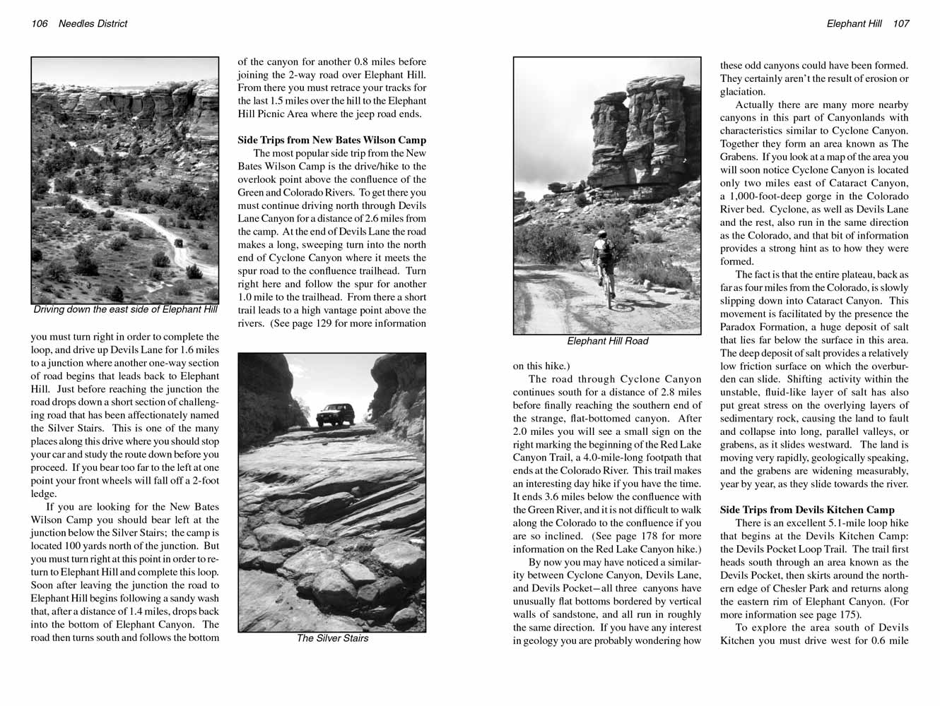
 The Elephant Hill road climbs the last 100 feet to the top of Elephant Hill over the next 300 yards, and then enters a relatively flat area at the
top of the hill that lasts for about 0.3 mile. The next order of business is to drop down the east side of Elephant Hill. Again, the route is very
steep, but not unreasonable, and the Park Service has used concrete in a few vital places to allow passage by conventional 4WD vehicles. The route
drops about 150 feet to a bench that marks the end of the most difficult part of the jeep trail.
The Elephant Hill road climbs the last 100 feet to the top of Elephant Hill over the next 300 yards, and then enters a relatively flat area at the
top of the hill that lasts for about 0.3 mile. The next order of business is to drop down the east side of Elephant Hill. Again, the route is very
steep, but not unreasonable, and the Park Service has used concrete in a few vital places to allow passage by conventional 4WD vehicles. The route
drops about 150 feet to a bench that marks the end of the most difficult part of the jeep trail.
After leaving Elephant Hill the road descends into Elephant Canyon and turns north to arrive at the junction where the one-way section of the loop
begins. Over the next 1.5 miles the road makes a long, sweeping turn to the south, gradually climbing out of Elephant Canyon through a small side
canyon on its east side. Then, just before reaching Devils Pocket and the Devils Kitchen Camp, the route passes through an exceedingly narrow slot
between two rock formations (which I am reminded of every time I look at the scratch on my jeep’s left side mirror). If you are driving an overly
wide vehicle you will probably be stopped at this point, but if you get through you will arrive at the Devils Kitchen Camp 0.3 mile later.
Devils Kitchen’s 4 campsites, situated in the midst of a field of huge, picturesque sandstone boulders, are among the nicest campsites you will find
anywhere in Canyonlands. They are also conveniently located, with several other points of interest nearby. If it can be arranged, you should try to
spend one or two nights at the Devils Kitchen Camp and make it a base for your exploration of the area.
Upon leaving Devils Kitchen the road makes an abrupt right turn and continues in a westward direction for 0.6 mile to another interesting canyon
called Devils Lane. Here you must turn right in order to complete the loop, and drive up Devils Lane for 1.6 miles to a junction where another
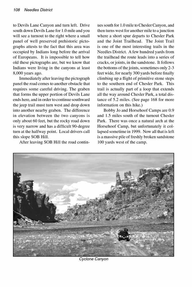
one-way section of road begins that leads back to Elephant Hill. Just before reaching the junction the road drops down a short section of
challenging road that has been affectionately named the Silver Stairs. This is one of the many places along this drive where you should stop
your car and study the route down before you proceed. If you bear too far to the left at one point your front wheels will fall off a 2-foot
ledge.
 If you are looking for the New Bates Wilson Camp you should bear left at the junction below the Silver Stairs; the camp is located
100 yards north of the junction. But you must turn right at this point in order to return to Elephant Hill and complete this loop. Soon after leaving
the junction the road to Elephant Hill begins following a sandy wash that, after a distance of 1.4 miles, drops back into the bottom of Elephant Canyon.
The road then turns south and follows the bottom of the canyon for another 0.8 miles before joining the 2-way road over Elephant Hill. From there
you must retrace your tracks for the last 1.5 miles over the hill to the Elephant Hill Picnic Area where the jeep road ends.
If you are looking for the New Bates Wilson Camp you should bear left at the junction below the Silver Stairs; the camp is located
100 yards north of the junction. But you must turn right at this point in order to return to Elephant Hill and complete this loop. Soon after leaving
the junction the road to Elephant Hill begins following a sandy wash that, after a distance of 1.4 miles, drops back into the bottom of Elephant Canyon.
The road then turns south and follows the bottom of the canyon for another 0.8 miles before joining the 2-way road over Elephant Hill. From there
you must retrace your tracks for the last 1.5 miles over the hill to the Elephant Hill Picnic Area where the jeep road ends.
Side Trips from New Bates Wilson Camp
The most popular side trip from the New Bates Wilson Camp is the drive/hike to the overlook point above the confluence of the Green and Colorado
Rivers. To get there you must continue driving north through Devils Lane Canyon for a distance of 2.6 miles from the camp. At the end of Devils
Lane the road makes a long, sweeping turn into the north end of Cyclone Canyon where it meets the spur road to the confluence trailhead. Turn
right here and follow the spur for another 1.0 mile to the trailhead. From there a short trail leads to a high vantage point above the rivers.
(See page 129 for more information on this hike.)
The road through Cyclone Canyon continues south for a distance of 2.8 miles before finally reaching the southern end of the strange, flat-bottomed
canyon. After 2.0 miles you will see a small sign on the right marking the beginning of the Red Lake Canyon Trail, a 4.0-mile-long footpath that
ends at the Colorado River. This trail makes an interesting day hike if you have the time. It ends 3.6 miles below the confluence with the Green
River, and it is not difficult to walk along the Colorado to the confluence if you are so inclined. (See page 178 for more information on the Red
Lake Canyon hike.)
By now you may have noticed a similarity between Cyclone Canyon, Devils Lane, and Devils Pocket: all three canyons have unusually flat bottoms
bordered by vertical walls of sandstone, and all run in roughly the same direction. If you have any interest in geology you are probably wondering
how these odd canyons could have been formed. They certainly aren’t the result of erosion or glaciation.
Actually there are many more nearby canyons in this part of Canyonlands with characteristics similar to Cyclone Canyon. Together they form an area
known as The Grabens. If you look at a map of the area you will soon notice Cyclone Canyon is located only two miles east of Cataract Canyon, a
1,000-foot-deep gorge in the Colorado River bed. Cyclone Canyon, as well as Devils Lane and the rest, also run in the same direction as the Colorado,
and that bit of information provides a strong hint as to how they were formed.
 The fact is that the entire plateau, back as far as four miles from the Colorado, is slowly slipping down into Cataract Canyon. This
movement is facilitated by the presence of the Paradox Formation, a huge deposit of salt that lies far below the surface in this area. The deep deposit of
salt provides a relatively low friction surface on which the overburden can slide. Shifting activity within the unstable, fluid-like layer of salt has
also put great stress on the overlying layers of sedimentary rock, causing the land to fault and collapse into long, parallel valleys, or grabens, as
it slides westward. The land is moving very rapidly, geologically speaking, and the grabens are widening measurably, year by year, as they slide
towards the river.
The fact is that the entire plateau, back as far as four miles from the Colorado, is slowly slipping down into Cataract Canyon. This
movement is facilitated by the presence of the Paradox Formation, a huge deposit of salt that lies far below the surface in this area. The deep deposit of
salt provides a relatively low friction surface on which the overburden can slide. Shifting activity within the unstable, fluid-like layer of salt has
also put great stress on the overlying layers of sedimentary rock, causing the land to fault and collapse into long, parallel valleys, or grabens, as
it slides westward. The land is moving very rapidly, geologically speaking, and the grabens are widening measurably, year by year, as they slide
towards the river.
Side Trips from Devils Kitchen Camp
There is an excellent 5.1-mile loop hike that begins at the Devils Kitchen Camp: the Devils Pocket Loop Trail. The trail first heads south through
an area known as the Devils Pocket, then skirts around the northern edge of Chesler Park and returns along the eastern rim of Elephant Canyon. (For
more information see page 175).
To explore the area south of Devils Kitchen you must drive west for 0.6 mile to Devils Lane Canyon and turn left. Drive south down Devils Lane for
1.0 mile and you will see a turnout to the right where a small panel of well preserved prehistoric pictographs attests to the fact that this area
was occupied by Indians long before the arrival of Europeans. It is impossible to tell how old these pictographs are, but we know that Indians
were living in the canyons at least 8,000 years ago.
Immediately after leaving the pictograph panel the road comes to another obstacle that requires some careful driving. The graben that forms the
upper portion of Devils Lane ends here, and in order to continue southward the jeep trail must turn west and drop down into another nearby graben.
The difference in elevation between the two canyons is only about 60 feet, but the rocky road down is very narrow and has a difficult 90-degree
turn at the halfway point. Local drivers call this slope SOB Hill.
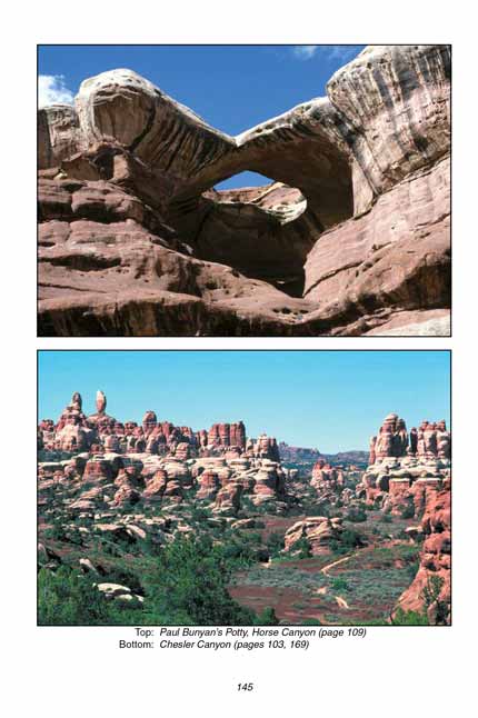
After leaving SOB Hill the road continues south for 1.0 mile to Chesler Canyon, and then turns west for another mile to a junction where a short
spur departs to Chesler Park and the Joint Trailhead. The Joint Trail is one of the most interesting trails in the Needles District. A few
hundred yards from the trailhead the route leads into a series of cracks, or joints, in the sandstone. It follows the bottoms of the joints,
sometimes only 2-3 feet wide, for nearly 300 yards before finally climbing up a flight of primitive stone steps to the southern end of Chesler
Park. This trail is actually part of a loop that extends all the way around Chesler Park, a total distance of 5.2 miles. (See page 168 for
more information on this hike.)
Bobby Jo and Horsehoof Camps are 0.9 and 1.5 miles south of the turnout Chesler Park. There was once a natural arch at the Horsehoof Camp, but
unfortunately it collapsed sometime in 1999. Now all that is left is a massive pile of freshly broken sandstone 100 yards west of the camp.
Note to web developers: You may copy this material onto your site, but in return please include a link to my home page
www.utahtrails.com. Thank you, David Day (utahdavidday at gmail.com)
Click here to see more trails in
Canyonlands National Park
© Rincon Publishing Company, all rights reserved
|