Chesler Park
excerpted from our book
Canyonlands National Park
Favorite Jeep Roads & Hiking Trails
pages 168-172
|
Buy book directly from the author!
Canyonlands National Park
Favorite Jeep Roads & Hiking Trails
- has access info for 75 trailheads
- 56 detailed trail maps
- 241 photographs
- loads of driving and hiking tips
|
regularly $14.95
now on sale for only
$11.95
click here
for book orders
|
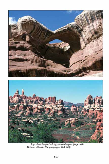
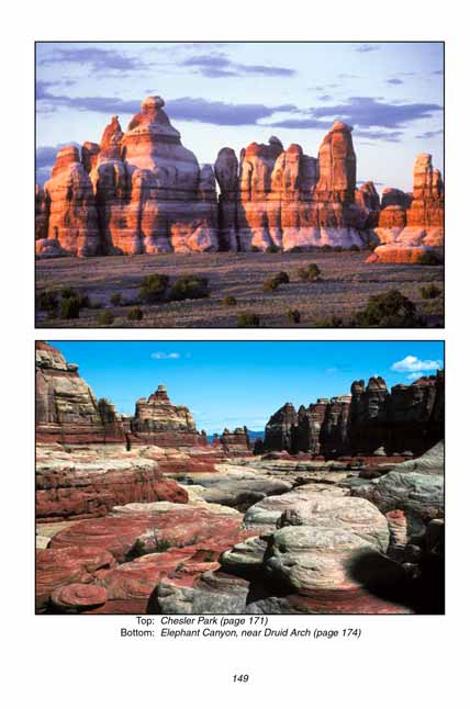
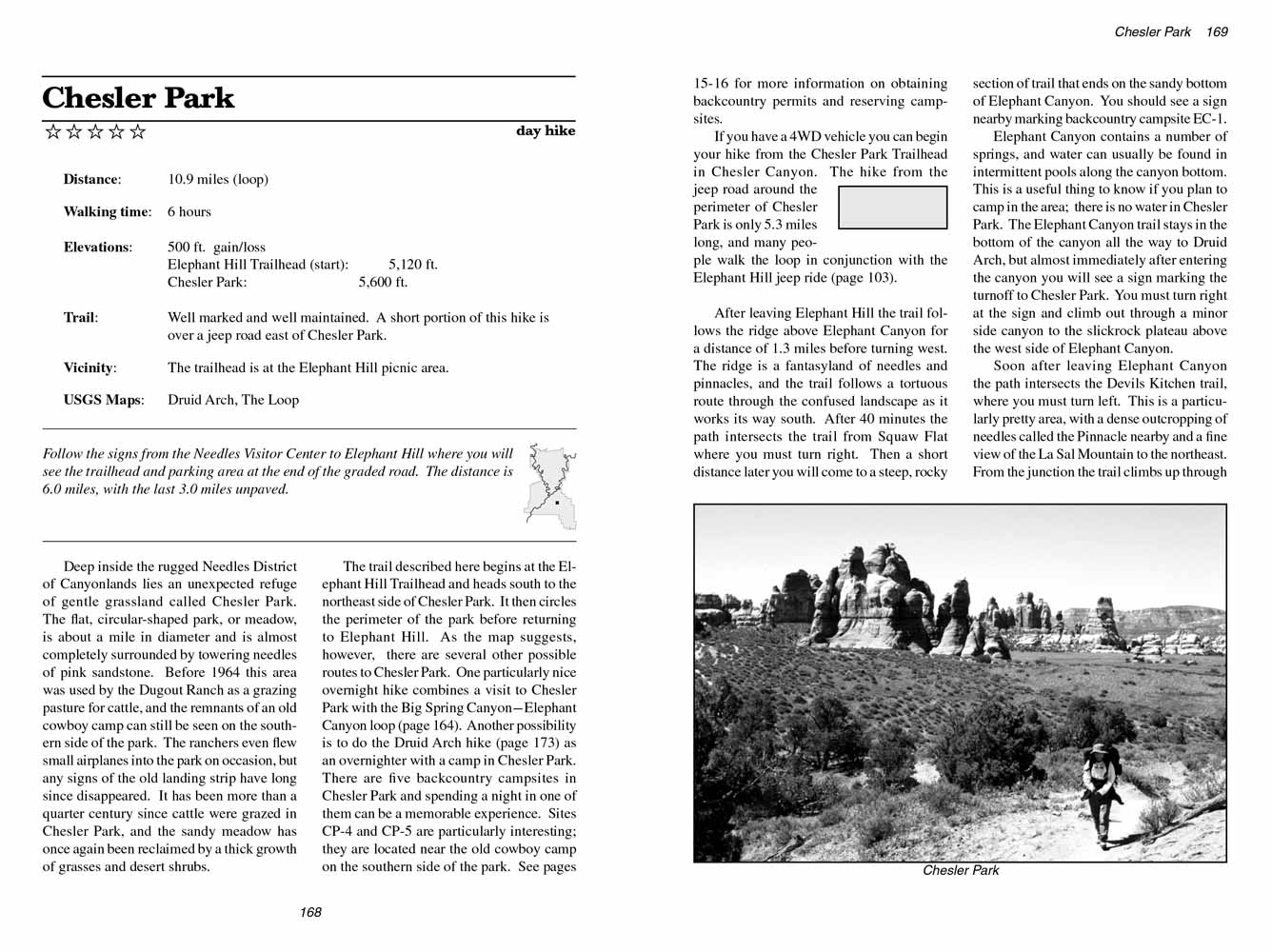 Deep inside the rugged Needles District of Canyonlands
National Park lies an unexpected refuge of gentle grassland called Chesler Park.
The flat, circular-shaped park, or meadow, is about a mile in diameter and is almost completely surrounded by towering needles of pink sandstone.
Before 1964 this area was used by the Dugout Ranch as a grazing pasture for cattle, and the remnants of an old cowboy camp can still be seen on the southern side of
Chesler Park.
The ranchers even flew small airplanes into the park on occasion, but any signs of the old landing strip have long since disappeared.
It has been more than a quarter century since cattle were grazed in Chesler Park, and the sandy meadow has once again been reclaimed by a thick growth of grasses and desert shrubs.
Deep inside the rugged Needles District of Canyonlands
National Park lies an unexpected refuge of gentle grassland called Chesler Park.
The flat, circular-shaped park, or meadow, is about a mile in diameter and is almost completely surrounded by towering needles of pink sandstone.
Before 1964 this area was used by the Dugout Ranch as a grazing pasture for cattle, and the remnants of an old cowboy camp can still be seen on the southern side of
Chesler Park.
The ranchers even flew small airplanes into the park on occasion, but any signs of the old landing strip have long since disappeared.
It has been more than a quarter century since cattle were grazed in Chesler Park, and the sandy meadow has once again been reclaimed by a thick growth of grasses and desert shrubs.
The trail described here begins at the Elephant Hill Trailhead and heads south to the northeast side of Chesler Park.
It then circles the perimeter of the park before returning to Elephant Hill. As the map suggests, however, there are several other possible routes to Chesler Park.
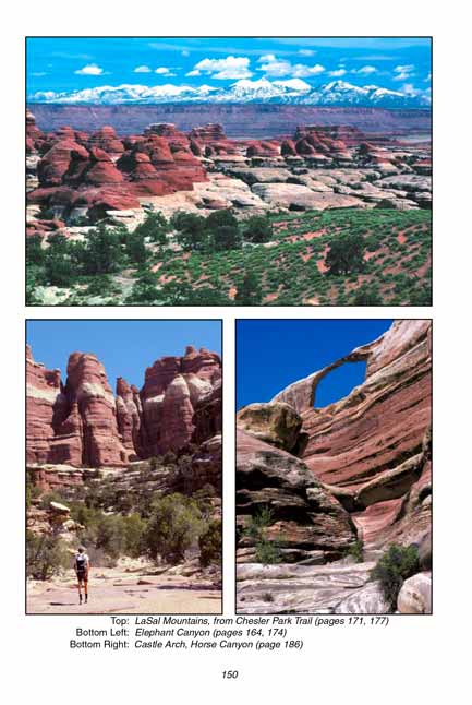
One particularly nice overnight hike combines a visit to Chesler Park with the Big Spring Canyon-Elephant Canyon loop (page 164).
Another possibility is to do the Druid Arch hike (page 173) as an overnighter with a camp in Chesler Park.
There are five backcountry campsites in Chesler Park and spending a night in one of them can be a memorable experience. Sites CP-4 and CP-5 are particularly interesting; they are located near the old cowboy camp on the southern side of the park. See pages 15-16 for more information on obtaining backcountry permits and reserving campsites.
If you have a 4WD vehicle you can begin your hike from the Chesler Park Trailhead in Chesler Canyon.
The hike from the jeep road around the perimeter of Chesler Park is only 5.3 miles long, and many people walk the loop in conjunction with the Elephant Hill jeep ride (page 103).
After leaving the Elephant Hill trailhead the trail follows the ridge above Elephant Canyon for a distance of 1.3 miles before turning west.
The ridge is a fantasyland of needles and pinnacles, and the trail follows a tortuous route through the confused landscape as it works its way south.
After 40 minutes the Chesler Park trail intersects the trail from Squaw Flat where you must turn right.
Then a short distance later you will come to a steep, rocky section of trail that ends on the sandy bottom of Elephant Canyon.
You should see a sign nearby marking backcountry campsite EC-1.
 Elephant Canyon contains a number of springs, and water can usually be found in intermittent pools along the canyon bottom.
This is a useful thing to know if you plan to camp in the area; there is no water in Chesler Park.
The Elephant Canyon trail stays in the bottom of the canyon all the way to Druid Arch, but almost immediately after entering the canyon you will see a sign marking the turnoff to Chesler Park.
You must turn right at the sign and climb out through a minor side canyon to the slickrock plateau above the west side of Elephant Canyon.
Elephant Canyon contains a number of springs, and water can usually be found in intermittent pools along the canyon bottom.
This is a useful thing to know if you plan to camp in the area; there is no water in Chesler Park.
The Elephant Canyon trail stays in the bottom of the canyon all the way to Druid Arch, but almost immediately after entering the canyon you will see a sign marking the turnoff to Chesler Park.
You must turn right at the sign and climb out through a minor side canyon to the slickrock plateau above the west side of Elephant Canyon.
Soon after leaving Elephant Canyon the path to Chesler
Park intersects the Devils Kitchen trail, where you must turn left.
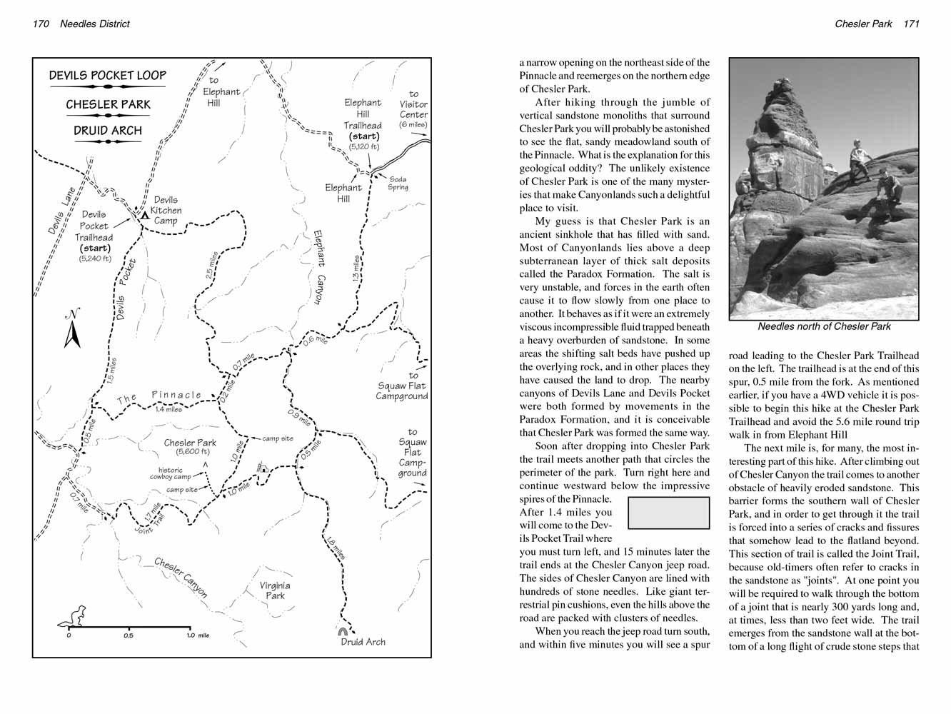
This is a particularly pretty area, with a dense outcropping of needles called the Pinnacle nearby and a fine view of the La Sal Mountain to the northeast.
From the junction the trail climbs up through a narrow opening on the northeast side of the Pinnacle and reemerges on the northern edge of Chesler Park.
After hiking through the jumble of vertical sandstone monoliths that surround Chesler Park you will probably be astonished to see the flat, sandy meadowland south of the Pinnacle.
What is the explanation for this geological oddity? The unlikely existence of Chesler Park is one of the many mysteries that make Canyonlands
National Park such a delightful place to visit.
My guess is that Chesler Park is an ancient sinkhole that has filled with sand.
Most of Canyonlands National Park lies above a deep subterranean layer of thick salt deposits called the Paradox Formation.
The salt is very unstable, and forces in the earth often cause it to flow slowly from one place to another.
It behaves as if it were an extremely viscous incompressible fluid trapped beneath a heavy overburden of sandstone.
In some areas the shifting salt beds have pushed up the overlying rock, and in other places they have caused the land to drop.
The nearby canyons of Devils Lane and Devils Pocket were both formed by movements in the Paradox Formation, and it is conceivable that Chesler Park was formed the same way.
 Soon after dropping into Chesler Park the trail meets another path that circles the perimeter of the park.
Turn right here and continue westward below the impressive spires of the Pinnacle.
After 1.4 miles you will come to the Devils Pocket Trail where you must turn left, and 15 minutes later the trail ends at the Chesler Canyon jeep road.
The sides of Chesler Canyon are lined with hundreds of stone needles. Like giant terrestrial pin cushions, even the hills above the road are packed with clusters of needles.
When you reach the jeep road turn south, and within five minutes you will see a spur road leading to the Chesler Park Trailhead on the left.
The trailhead is at the end of this spur, 0.5 mile from the fork.
As mentioned earlier, if you have a 4WD vehicle it is possible to begin this hike at the Chesler Park Trailhead and avoid the 5.6 mile round trip walk in from Elephant Hill.
Soon after dropping into Chesler Park the trail meets another path that circles the perimeter of the park.
Turn right here and continue westward below the impressive spires of the Pinnacle.
After 1.4 miles you will come to the Devils Pocket Trail where you must turn left, and 15 minutes later the trail ends at the Chesler Canyon jeep road.
The sides of Chesler Canyon are lined with hundreds of stone needles. Like giant terrestrial pin cushions, even the hills above the road are packed with clusters of needles.
When you reach the jeep road turn south, and within five minutes you will see a spur road leading to the Chesler Park Trailhead on the left.
The trailhead is at the end of this spur, 0.5 mile from the fork.
As mentioned earlier, if you have a 4WD vehicle it is possible to begin this hike at the Chesler Park Trailhead and avoid the 5.6 mile round trip walk in from Elephant Hill.
The next mile is, for many, the most interesting part of this hike. After climbing out of Chesler Canyon the trail comes to another obstacle of heavily eroded sandstone.
This barrier forms the southern wall of Chesler Park, and in order to get through it the trail is forced into a series of cracks and fissures that somehow lead to the flatland beyond.
This section of trail is called the Joint Trail, because old-timers often refer to cracks in the sandstone as "joints".
At one point you will be required to walk through the bottom of a joint that is nearly 300 yards long and, at times, less than two feet wide.
The trail emerges from the sandstone wall at the bottom of a long flight of crude stone steps that climb back to the sunshine and blue sky on the southern edge of Chesler Park.
After climbing the steps the trail turns east along the southern side of Chesler
Park.
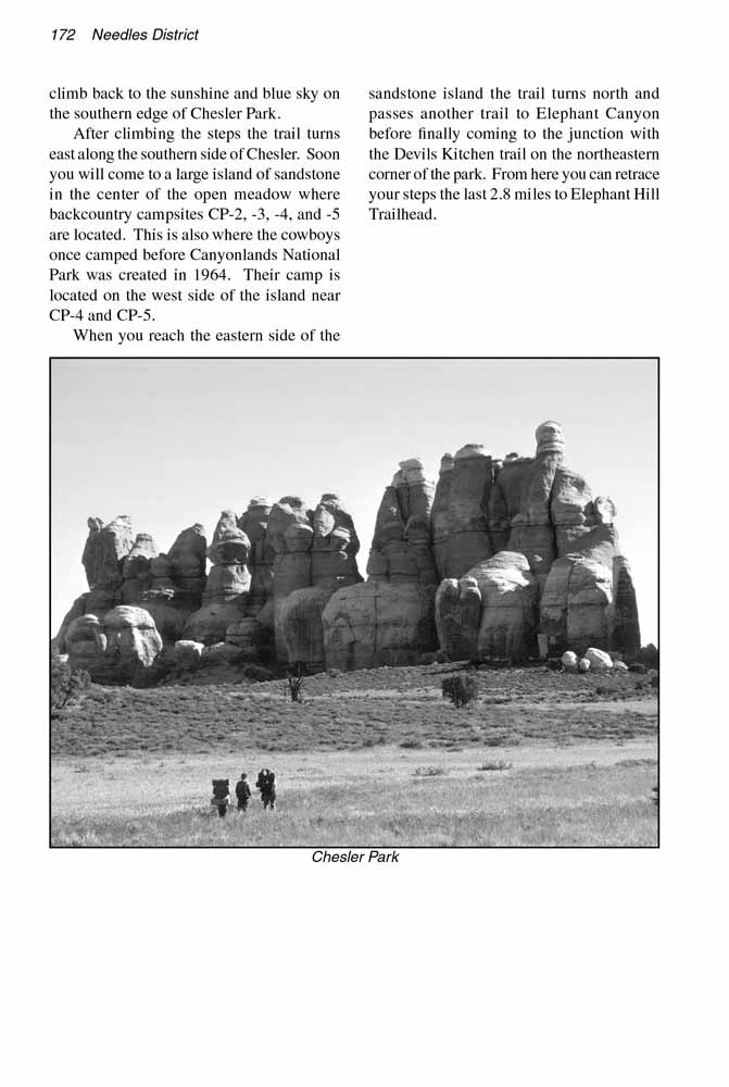
Soon you will come to a large island of sandstone in the center of the open meadow where backcountry campsites CP-2, -3, -4, and -5 are located.
This is also where the cowboys once camped before Canyonlands National Park was created in 1964. Their camp is located on the west side of the island near CP-4 and CP-5.
When you reach the eastern side of the sandstone island the trail turns north and passes another trail to Elephant Canyon before finally coming to the junction with the Devils Kitchen trail on
the northeastern corner of the park. From here you can retrace your steps the last 2.8 miles to Elephant Hill Trailhead.
Note to web developers: You may copy this material onto your site, but in return please include a link to my home page
www.utahtrails.com. Thank you, David Day (utahdavidday at gmail.com)
Click here to see more trails in
Canyonlands National Park
© Rincon Publishing Company, all rights reserved
|