Aztec Butte Trail
excerpted from our book
Canyonlands National Park
Favorite Jeep Roads & Hiking Trails
pages 62-63
|
Buy book directly from the author!
Canyonlands National Park
Favorite Jeep Roads & Hiking Trails
- has access info for 75 trailheads
- 56 detailed trail maps
- 241 photographs
- loads of driving and hiking tips
|
regularly $14.95
now on sale for only
$11.95
click here
for book orders
|
 Before 1300 A.D. there were many Anasazi Indians living within the boundaries of Canyonlands National Park. They generally lived in
the canyons below the mesas where water was more abundant-particularly along the Green River. But they also made frequent trips to the mesa tops for the
purpose of gathering food, and there is still a great deal of evidence of their habitation on the Island in the Sky Mesa. The best place to see the
remnants of these prehistoric people is on Aztec Butte, where the Anasazis built a number of granaries for storing the food they collected.
Before 1300 A.D. there were many Anasazi Indians living within the boundaries of Canyonlands National Park. They generally lived in
the canyons below the mesas where water was more abundant-particularly along the Green River. But they also made frequent trips to the mesa tops for the
purpose of gathering food, and there is still a great deal of evidence of their habitation on the Island in the Sky Mesa. The best place to see the
remnants of these prehistoric people is on Aztec Butte, where the Anasazis built a number of granaries for storing the food they collected.
From the car parking area the Aztec Butte trail goes east across the sandy desert for 0.6 mile to the base of the butte. It then heads up the west side of the hill,
climbing steeply over the slickrock in a few places, and finally reaches the flat top of Aztec Butte after an elevation gain of 200 feet. Once on the
top you will see several trails, and it may be confusing trying to decide which one to follow. Just remember that there is one ruin on the top
southeastern side of the hill and several more just under the rim on the northern side. I suggest that you first make your way to the southeastern
side of the butte to see the top ruin. Then find a primitive trail near that ruin that drops about 15 feet below the rim and follows a narrow bench
around to the other ruins on the north side.
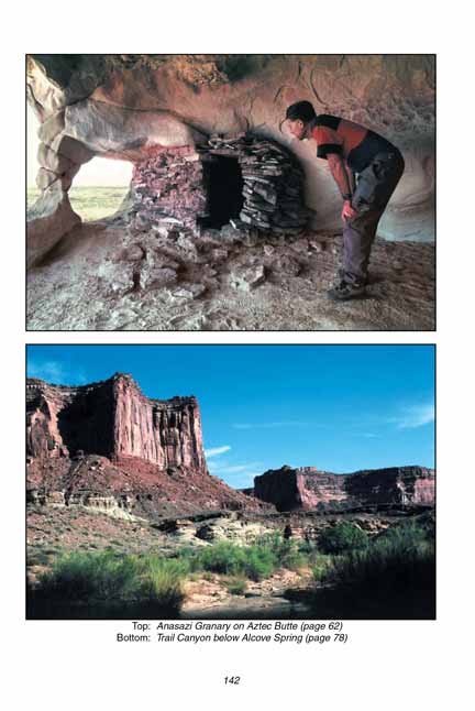
The ruin on the top of the Aztec Butte mesa looks big enough to have served as a dwelling for a good-sized family. It has been heavily reconstructed, however, and
it is hard to tell exactly what the original structure looked like. The most interesting
Aztec Butte ruins are located along the ledge on the north side of the
butte, where there are a number of small alcoves. These well-protected alcoves would have been ideal locations for granaries, and at least a half-dozen
of them contain Anasazi artifacts. Some of the structures are so crudely made, however, that I wonder if they were not built by other hikers rather
than the Anasazis.
The high point of the Aztec Butte hike is the last granary you will come to on the northwest side of Aztec Butte. This granary is in excellent condition, and it
is also situated in a very picturesque setting. The alcove has two pillars of sandstone that rise from the floor to the ceiling, forming three small
arches. There is also a magnificent view into Trail Canyon from the site. This location would have been a very pleasant place to rest after a hunting
trip across the mesa below.
About halfway from Aztec Butte back to the trailhead you will see a secondary spur trail on the right leading to a small hill west of the larger butte.
Be sure to explore this trail before returning to your car. It will lengthen your hike by only 20 minutes, but your reward will be two more finely
preserved granaries. After an elevation gain of about 100 feet the trail comes to the top of the low hill, and then drops into another alcove on
the north side where the Aztec Butte granaries are located. These granaries are each about 8 feet in diameter and 3 feet high.
Note to web developers: You may copy this material onto your site, but in return please include a link to my home page
www.utahtrails.com. Thank you, David Day (utahdavidday at gmail.com)
Click here to see more trails in
Canyonlands National Park
© Rincon Publishing Company, all rights reserved
|