Anderson Bottom
excerpted from our book
Canyonlands National Park
Favorite Jeep Roads & Hiking Trails
pages 246-250
|
Buy book directly from the author!
Canyonlands National Park
Favorite Jeep Roads & Hiking Trails
- has access info for 75 trailheads
- 56 detailed trail maps
- 241 photographs
- loads of driving and hiking tips
|
regularly $14.95
now on sale for only
$11.95
click here
for book orders
|
 Most of the bottom land along the Green River in Canyonlands National Park was farmed or homesteaded at one time or another during the early 1900s, but none of the river bottoms saw as much human activity as Anderson Bottom. At least seven different families attempted to establish ranches or farms here. They all failed not because the land was infertile but because it was too remote, too hard to supply, and too lonely. Albert Issac Anderson, the first settler on Anderson Bottom, lived there for three summers between 1909 and 1911. He intended to homestead the bottom, but eventually moved away because his sons didn’t want to live there. Anderson was followed by a succession of ranchers who ran sheep and cattle in the area before it became part of Canyonlands National Park.
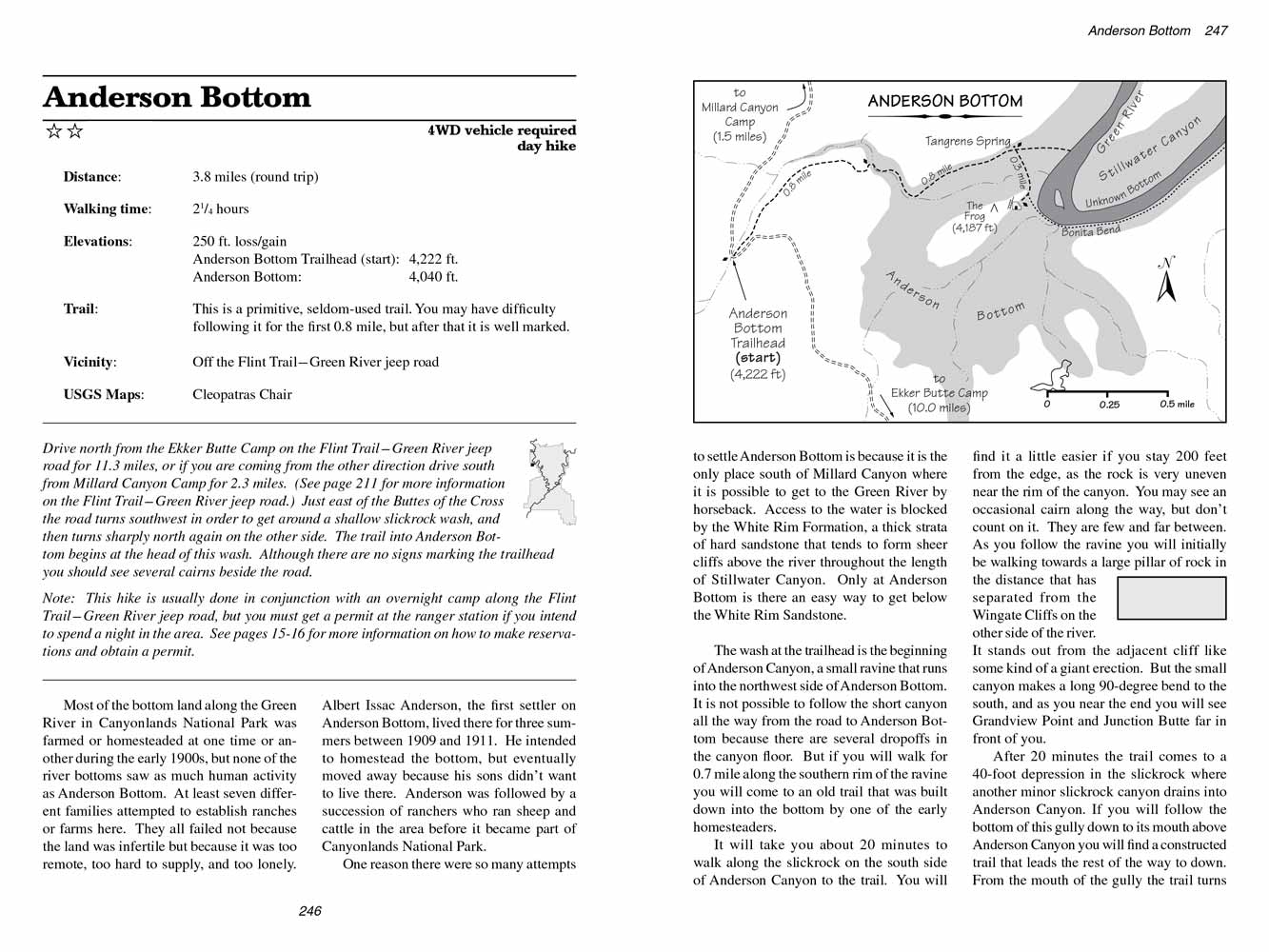
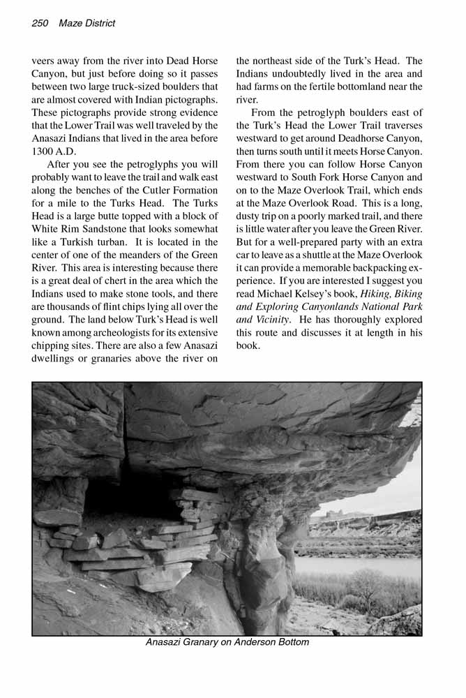
One reason there were so many attempts to settle Anderson Bottom is because it is the only place south of Millard Canyon where it is possible to get to the Green River by horseback. Access to the water is blocked by the White Rim Formation, a thick strata of hard sandstone that tends to form sheer cliffs above the river throughout the length of Stillwater Canyon. Only at Anderson Bottom is there an easy way to get below the White Rim Sandstone.
The wash at the trailhead is the beginning of Anderson Canyon, a small ravine that runs into the northwest side of Anderson Bottom. It is not possible to follow the short canyon all the way from the road to Anderson Bottom because there are several dropoffs in the canyon floor. But if you will walk for 0.7 mile along the southern rim of the ravine you will come to an old trail that was built down into the bottom by one of the early homesteaders.
It will take you about 20 minutes to walk along the slickrock on the south side of Anderson Canyon to the trail. You will find it a little easier if you stay 200 feet from the edge, as the rock is very uneven near the rim of the canyon. You may see an occasional cairn along the way, but don’t count on it. They are few and far between. As you follow the ravine you will initially be walking towards a large pillar of rock in the distance that has separated from the Wingate Cliffs on the other side of the river. It stands out from the adjacent cliff like some kind of a giant erection. But the small canyon makes a long 90-degree bend to the south, and as you near the end you will see Grandview Point and Junction Butte far in front of you.
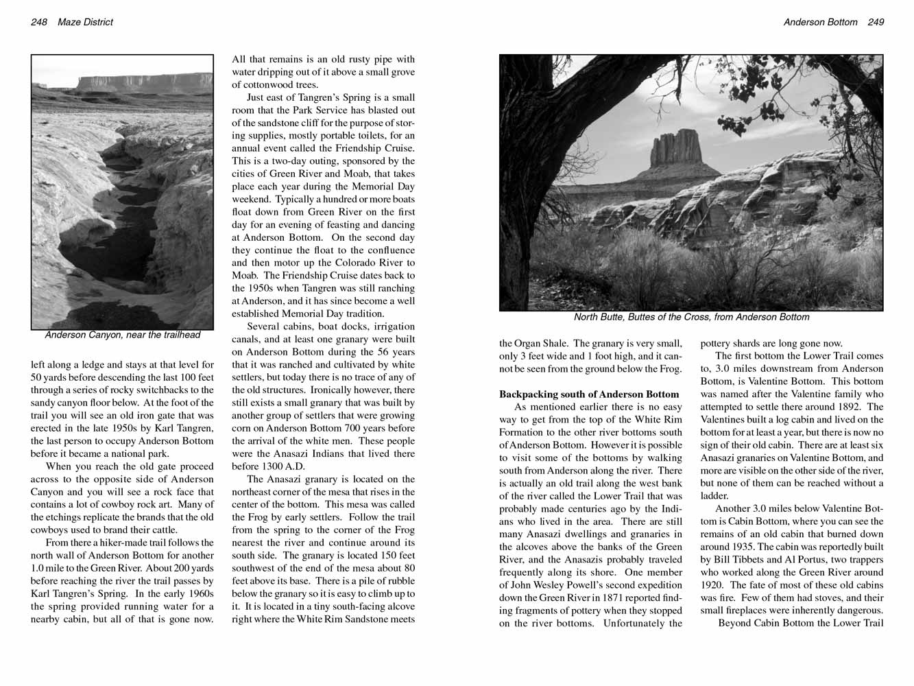 After 20 minutes the trail comes to a 40-foot depression in the slickrock where another minor slickrock canyon drains into Anderson Canyon. If you will follow the bottom of this gully down to its mouth above Anderson Canyon you will find a constructed trail that leads the rest of the way to down. From the mouth of the gully the trail turns left along a ledge and stays at that level for 50 yards before descending the last 100 feet through a series of rocky switchbacks to the sandy canyon floor below. At the foot of the trail you will see an old iron gate that was erected in the late 1950s by Karl Tangren, the last person to occupy Anderson Bottom before it became a national park.
When you reach the old gate proceed across to the opposite side of Anderson Canyon and you will see a rock face that contains a lot of cowboy rock art. Many of the etchings replicate the brands that the old cowboys used to brand their cattle.
From there a hiker-made trail follows the north wall of Anderson Bottom for another 1.0 mile to the Green River. About 200 yards before reaching the river the trail passes by Karl Tangren’s Spring. In the early 1960s the spring provided running water for a nearby cabin, but all of that is gone now. All that remains is an old rusty pipe with water dripping out of it above a small grove of cottonwood trees.
Just east of Tangren’s Spring is a small room that the Park Service has blasted out of the sandstone cliff for the purpose of storing supplies, mostly portable toilets, for an annual event called the Friendship Cruise. This is a two-day outing, sponsored by the cities of Green River and Moab, that takes place each year during the Memorial Day weekend. Typically a hundred or more boats float down from Green River on the first day for an evening of feasting and dancing at Anderson Bottom. On the second day they continue the float to the confluence and then motor up the Colorado River to Moab. The Friendship Cruise dates back to the 1950s when Tangren was still ranching at Anderson, and it has since become a well established Memorial Day tradition.
Several cabins, boat docks, irrigation canals, and at least one granary were built on Anderson Bottom during the 56 years that it was ranched and cultivated by white settlers, but today there is no trace of any of the old structures. Ironically however, there still exists a small granary that was built by another group of settlers that were growing corn on Anderson Bottom 700 years before the arrival of the white men. These people were the Anasazi Indians that lived there before 1300 A.D.
 The Anasazi granary is located on the northeast corner of the mesa that rises in the center of the bottom. This mesa was called the Frog by early settlers. Follow the trail from the spring to the corner of the Frog nearest the river and continue around its south side. The granary is located 150 feet southwest of the end of the mesa about 80 feet above its base. There is a pile of rubble below the granary so it is easy to climb up to it. It is located in a tiny south-facing alcove right where the White Rim Sandstone meets the Organ Shale. The granary is very small, only 3 feet wide and 1 foot high, and it cannot be seen from the ground below the Frog.
Backpacking south of Anderson Bottom
As mentioned earlier there is no easy way to get from the top of the White Rim Formation to the other river bottoms south of Anderson Bottom. However it is possible to visit some of the bottoms by walking south from Anderson along the river. There is actually an old trail along the west bank of the river called the Lower Trail that was probably made centuries ago by the Indians who lived in the area. There are still many Anasazi dwellings and granaries in the alcoves above the banks of the Green River, and the Anasazis probably traveled frequently along its shore. One member of John Wesley Powell’s second expedition down the Green River in 1871 reported finding fragments of pottery when they stopped on the river bottoms. Unfortunately the pottery shards are long gone now.
The first bottom the Lower Trail comes to, 3.0 miles downstream from Anderson Bottom, is Valentine Bottom. This bottom was named after the Valentine family who attempted to settle there around 1892. The Valentines built a log cabin and lived on the bottom for at least a year, but there is now no sign of their old cabin. There are at least six Anasazi granaries on Valentine Bottom, and more are visible on the other side of the river, but none of them can be reached without a ladder.
Another 3.0 miles below Valentine Bottom is Cabin Bottom, where you can see the remains of an old cabin that burned down around 1935. The cabin was reportedly built by Bill Tibbets and Al Portus, two trappers who worked along the Green River around 1920. The fate of most of these old cabins was fire. Few of them had stoves, and their small fireplaces were inherently dangerous.
Beyond Cabin Bottom the Lower Trail veers away from the river into Dead Horse Canyon, but just before doing so it passes between two large truck-sized boulders that are almost covered with Indian pictographs. These pictographs provide strong evidence that the Lower Trail was well traveled by the Anasazi Indians that lived in the area before 1300 A.D.
After you see the petroglyphs you will probably want to leave the trail and walk east along the benches of the Cutler Formation for a mile to the Turks Head. The Turks Head is a large butte topped with a block of White Rim Sandstone that looks somewhat like a Turkish turban. It is located in the center of one of the meanders of the Green River. This area is interesting because there is a great deal of chert in the area which the Indians used to make stone tools, and there are thousands of flint chips lying all over the ground. The land below Turk’s Head is well known among archeologists for its extensive chipping sites. There are also a few Anasazi dwellings or granaries above the river on the northeast side of the Turk’s Head. The Indians undoubtedly lived in the area and had farms on the fertile bottomland near the river.
From the petroglyph boulders east of the Turk’s Head the Lower Trail traverses westward to get around Deadhorse Canyon, then turns south until it meets Horse Canyon. From there you can follow Horse Canyon westward to South Fork Horse Canyon and on to the Maze Overlook Trail, which ends at the Maze Overlook Road. This is a long, dusty trip on a poorly marked trail, and there is little water after you leave the Green River. But for a well-prepared party with an extra car to leave as a shuttle at the Maze Overlook it can provide a memorable backpacking experience. If you are interested I suggest you read Michael Kelsey’s book, Hiking, Biking and Exploring Canyonlands National Park and Vicinity. He has thoroughly explored this route and discusses it at length in his book.
Note to web developers: You may copy this material onto your site, but in return please include a link to my home page
www.utahtrails.com. Thank you, David Day (utahdavidday at gmail.com)
Click here to see more trails in
Canyonlands National Park
© Rincon Publishing Company, all rights reserved
|