The attraction that draws most hikers to Willow Gulch is
the magnificent Broken Bow Natural Arch. This improbable sandstone formation
rises boldly from a low plateau on the north side of the streambed, where it
can be seen clearly from a distance of several hundred yards. The
triangular-shaped opening easily reminds one of a bow bent nearly double,
but actually that is not how the arch got its name. It was given its present
name in 1930 after an Indian bow was found underneath it.
Broken Bow Arch is located only 2.3 miles from the Willow
Gulch Trailhead. It is a relatively easy hike to the arch, and many hikers
turn around at that point. But in my opinion the hike from the arch on down
to Lake Powell is almost as interesting as the arch itself. The character of
the canyon changes dramatically in a surprisingly short distance, going from
an open desert environment to a constricted environment of slickrock
waterslides and sandstone narrows in less than a mile. Finally the canyon
opens out again at the end, where a small plateau offers a fine view of Lake
Powell.
From the parking area it may be difficult to see exactly
where the trail starts, but if you walk in a northerly direction from the
registration box, straight down the sandy slope, you will soon begin to see
the trail. Look for a large sandstone boulder that looks like an upside-down
Mexican hat about 150 yards from the trailhead. The trail passes within a
few feet of the boulder, and then turns east for the descent into a short
side canyon that eventually leads to Willow gulch.
This unnamed side canyon is interesting in its own right.
It is dry and dusty, with cliffs of Navajo Sandstone on both sides and a
short stretch of nicely sculpted narrows in its center. The trail generally
follows the right side of the canyon for 0.5 mile before dropping to the
bottom of the streambed. Shortly after the trail reaches the bottom of the
canyon you will come to an intersection where Cottonwood Wash enters from
the right and another short canyon comes in from the left. You may be
confused at this intersection, as there are three possible routes to follow.
Do not turn right or left, but continue straight through the intersection
into the sandy wash that continues on the other side.
At this point you are in the lower part of Cottonwood
Wash. Except in very wet years the canyon is bone dry, but, interestingly,
it contains signs of beaver. Notice the stunted cottonwood trees struggling
to find water under the sand; many of them have been damaged by the
wood-eating rodents. You can take that as an indication that there is water
ahead, but it is surprising how far the beaver venture into the dry canyon.
0.4 mile after entering Cottonwood Wash the canyon widens
again at the confluence with Willow Gulch. There are a great many willow
trees in the area (hence the name), and you should finally see some water in
the streambed. Turn left into Willow Gulch, but before continuing be sure to
make a mental note of what the confluence looks like so you will know where
to leave Willow on the return trip. What initially passed for a trail has
long since disappeared by this time; consequently it is easy to miss the
exit point from Willow Gulch when hiking out. If you do miss the turn you
can still reach the Hole in the Rock Road by continuing up Willow Gulch. But
if you do this you will have to walk another 2.9 miles along the road to get
from the head of Willow Gulch back to the trailhead.
You will pass a half-dozen small beaver dams as you walk
down Willow Gulch. The easiest place to walk is generally in the bottom of
the streambed, but the dams occasionally make detours necessary. The beavers
are seldom seen, but their handiwork is everywhere. It is probably the
pressure of overpopulation that causes some of them to venture up Cottonwood
Wash in search of another place to build a home. Finally, a half-hour after
entering Willow Gulch, Broken Bow Natural Arch should come into view.
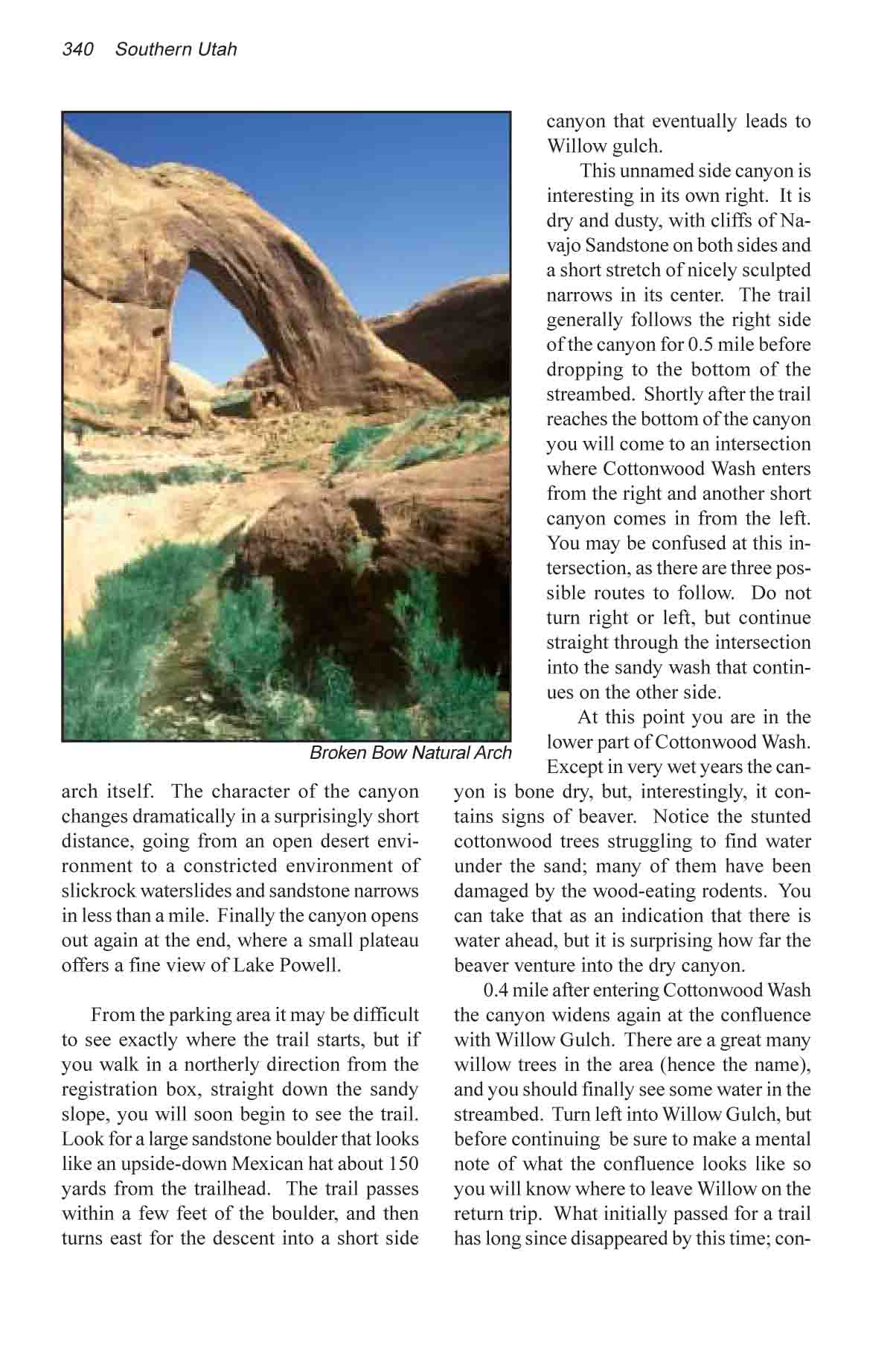
Broken Bow is surely one of the most beautiful arches in
the Escalante drainage. It curves gracefully away from the wall of the
canyon in a way that is reminiscent of Rainbow Natural Bridge, the world�s
largest natural arch. It is 170 feet high, with an opening 94 feet wide and
100 feet high. Its 70-foot-thick sides lend an element of strength to its
grace, assuring us that it is going to be here for a long time to come. Best
of all it lies in an easily accessible area, with no barriers on either
side, so good photographic angles are easy to find. And its most photogenic
side faces south, where it is in the sun for most of the day.
The Broken Bow Arch was sculpted from a fin of sandstone
that once protruded into the canyon from the west wall. The stream has never
actually flowed through the opening, and for this reason it is classified as
an arch and not a natural bridge. It seems, however, that the fickle creek
is intent on correcting this situation. As you walk through the streambed
you can see the undercutting that has began as the water tries to straighten
out its course and flow where Broken Bow now stands. The creek will probably
someday be the instrument that destroys the arch.
The effects of water on sandstone become more and more
apparent as you walk downstream from Broken Bow. The canyon becomes
narrower, deeper, colder, and more devoid of plant life as you approach its
mouth. In some sections the sensation is one of walking through a 20-foot
diameter pipe that has been scoured smooth by the grinding power of water
and sand. In other places it feels like you are walking along a racetrack
with galleries for the spectators in the huge alcoves above. There are
numerous waterslides along the way where the persistent stream has cut
graceful channels into the smooth sandstone. And in one part of the canyon
the water has carved out a 200-foot-long section of narrows that is scarcely
4 feet wide
Thirty minutes below Broken Bow Arch you will come to
Fortymile Gulch, another narrow, watery canyon that joins Willow Gulch from
the north, and soon afterward the canyon ends at Lake Powell. When the lake
is full the water may rise almost to the confluence with Fortymile Gulch,
but by the end of summer the lake has usually receded 0.5 mile below the
canyon junction. You will know you are getting close to the lake when you
start seeing a thick layer of mud on the canyon floor. The mud contains the
footprints of dozens of boaters who have landed and walked up Willow Gulch,
but they seldom go more than a few hundred yards.
Fortymile Gulch
An interesting variation to this hike is to return to the Hole in the
Rock Road through Fortymile Gulch and Carcass Wash. This route is somewhat
more difficult than the walk through Willow Gulch, however, so some
additional planning is needed. First, the walking distance is 3.9 miles
longer, bringing the total hiking distance around the loop to 11.1 miles.
Second, there is more water and more obstacles in Fortymile Gulch, so
progress is slower. There are at least two places in the lower part of
Fortymile where it is necessary to wade or swim through deep pools of water
that block the way. For this reason the hike should only be done in warm
weather, and if you are carrying a camera you should have some means of
keeping it dry. Finally, the Carcass Wash Trailhead is 3.6 miles by road
from the Willow Gulch Trailhead, so some kind of a shuttle is necessary to
get back to the starting point.
Carcass Wash is only one of three possible exit routes
from Fortymile Gulch to the Hole in the Rock Road, but it is, by far, the
easiest route. If you try to exit through Sooner Wash you will find a canyon
full of chock stones, and if you continue up Fortymile Gulch you will soon
find yourself in a box canyon with no apparent way out. Carcass Wash is the
second major canyon you will see on the left as you walk up Fortymile.
It is easy to miss the turn from Fortymile Gulch into
Carcass Wash, and for that reason it is probably better to do this loop hike
in the reverse direction. If you start at Carcass Wash the route simply
follows the canyon downstream to Fortymile Gulch and on to Willow Gulch.
Regardless of the direction you are traveling, however, be sure to pay
particular attention to the weather before entering Fortymile Gulch. A flash
flood in this canyon would be deadly, so don�t proceed if there is a
chance of rain.