Do you want to see the beautiful Bryce Canyon? Take an aerial tour today!
Interested in seeing the Grand Canyon or Monument Valley? You've come to the right spot!
|
Distance: 3.0 miles (loop) Walking time: 2 hours Elevations:
550 ft. loss/gain Trail: Excellent, well marked trail Season: Summer to mid-fall. The trail is covered with snow during the winter months. Vicinity: Bryce Canyon National Park |
|
|
Links to other sites:
Do you have any recent information to add about this trail? Ordering books & Maps Free sample copies of Outdoor Magazines Comments about this site or our book:
|
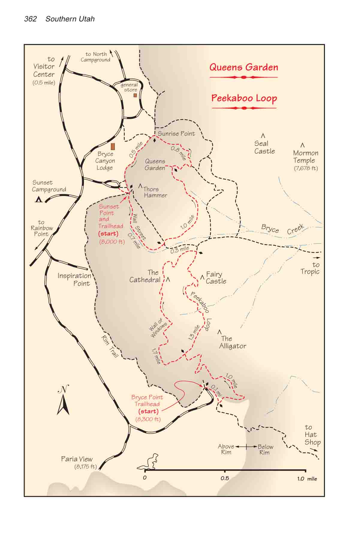
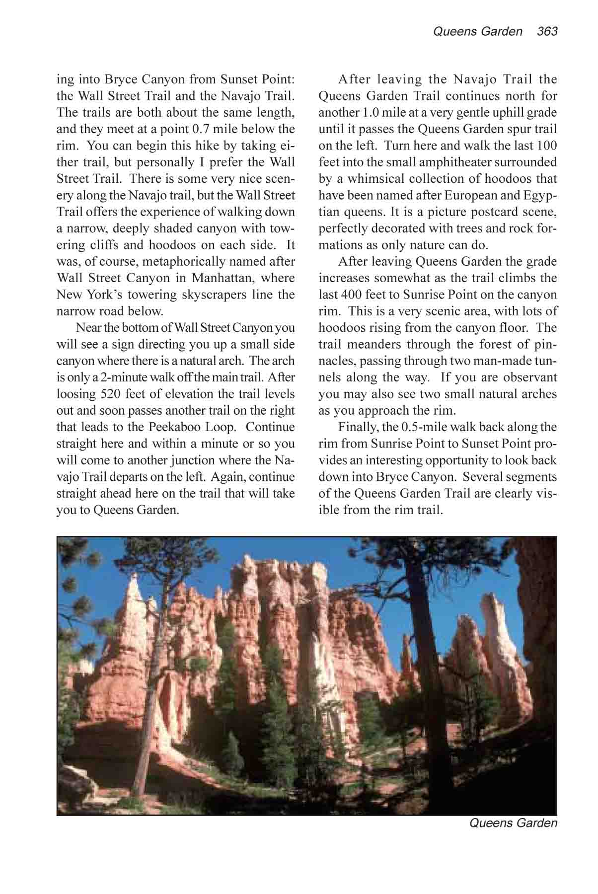
Bryce Canyon National Park is one place where you can see a lot of fantastic scenery in a very short time. There are numerous trails below the rim, especially in the area between Sunrise Point and Bryce Point, and several variations of this hike are possible. The route I will describe here descends below the rim through a narrow gorge called Wall Street Canyon. It then follows the Queens Garden Trail through an area that is filled with the weird and colorful geologic formations, called "hoodoos", that have made Bryce Canyon famous. Finally, the trail exits the canyon at Sunrise Point and turns to follow the rim back to Sunset Point where the hike began. Much of the route followed inside the canyon can also be seen from the rim trail, so you can enjoy Bryce Canyon�s unique geology from two different perspectives. There are two separate trails descending into Bryce Canyon from Sunset Point: the Wall Street Trail and the Navajo Trail. The trails are both about the same length, and they meet at a point 0.7 mile below the rim. You can begin this hike by taking either trail, but personally I prefer the Wall Street Trail. There is some very nice scenery along the Navajo trail, but the Wall Street Trail offers the experience of walking down a narrow, deeply shaded canyon with towering cliffs and hoodoos on each side. It was, of course, metaphorically named after Wall Street Canyon in Manhattan, where New York�s towering skyscrapers line the narrow road below. Near the bottom of Wall Street Canyon you will see a sign directing you up a small side canyon where there is a natural arch. The arch is only a 2-minute walk off the main trail. After loosing 520 feet of elevation the trail levels out and soon passes another trail on the right that leads to the Peekaboo Loop. Continue straight here and within a minute or so you will come to another junction where the Navajo Trail departs on the left. Again, continue straight ahead here on the trail that will take you to Queens Garden. After leaving the Navajo Trail the Queens Garden Trail continues north for another 1.0 mile at a very gentle uphill grade until it passes the Queens Garden spur trail on the left. Turn here and walk the last 100 feet into the small amphitheater surrounded by a whimsical collection of hoodoos that have been named after European and Egyptian queens. It is a picture postcard scene, perfectly decorated with trees and rock formations as only nature can do. After leaving Queens Garden the grade increases somewhat as the trail climbs the last 400 feet to Sunrise Point on the canyon rim. This is a very scenic area, with lots of hoodoos rising from the canyon floor. The trail meanders through the forest of pinnacles, passing through two man-made tunnels along the way. If you are observant you may also see two small natural arches as you approach the rim. Finally, the 0.5-mile walk back along the rim from Sunrise Point to Sunset Point provides an interesting opportunity to look back down into Bryce Canyon. Several segments of the Queens Garden Trail are clearly visible from the rim trail.
|
If you are interested in a supplemental map of the
Queens Garden area, we recommend:
Bryce Canyon National Park
(Trails Illustrated, map #219)