|
Links to other sites:
Do you have any recent information to add about this trail?
Ordering books & Maps
Comments about this site or our book:

|
Naomi Peak is the highest
point in the Bear River Mountains of northern Utah and southern
Idaho. While the limestone range is not very high it is extremely
rugged, and the views from the top of Naomi are outstanding.
Many of the most interesting peaks in the range can be seen from
the summit.
If you are hiking in late July
or August you will also be able to enjoy another highlight of
the Bear River Range: wildflowers. Nowhere else in Utah will
you see them in such staggering abundance. A colorful profusion
of geraniums, paintbrushes, columbines, lupines, daisies, and
mountain sunflowers stretch for miles across the meadows north
of Tony Grove Trailhead. It is a shame that these meadows were
not included in the 1984 Utah Wilderness Bill that created the
Mount Naomi Wilderness Area. Snowmobile operators frequent the
area in the winter, and they lobbied successfully to have the
watershed east of the peak excluded from the bill. This hike
touches only briefly on the eastern boundary of the wilderness
area.
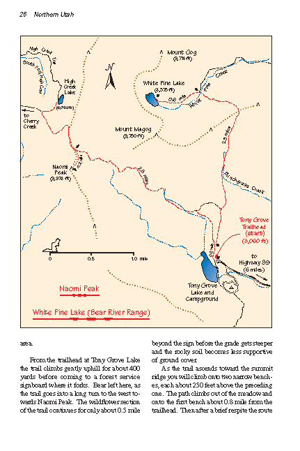
From
the trailhead at Tony Grove Lake the trail climbs gently uphill
for about 400 yards before coming to a forest service signboard
where it forks. Bear left here, as the trail goes into a long
turn to the west towards Naomi Peak. The wildflower section of
the trail continues for only about 0.5 mile beyond the sign before
the grade gets steeper and the rocky soil becomes less supportive
of ground cover.
As the trail ascends toward the
summit ridge you will climb onto two narrow benches, each about
250 feet above the preceding one. The path climbs out of the
meadow and onto the first bench about 0.8 mile from the trailhead.
Then after a brief respite the route becomes steep again until
the second bench is attained 0.8 mile farther along. From the
second bench the trail makes its third and last steep climb up
to the summit ridge just north of the peak.
Once you reach the summit ridge
it will be necessary to leave the trail and strike out along
the top of the ridge for the last 0.2 mile to the peak. The Mount
Naomi Wilderness Area boundary line also follows the ridge, and
you will see a forest service sign at the boundary just before
the point where you must leave the trail. It is an easy ten-minute
scramble along the summit ridge to the top of Naomi Peak. The
peak is only 140 feet higher than the pass, and there is no vegetation
to impede the way.
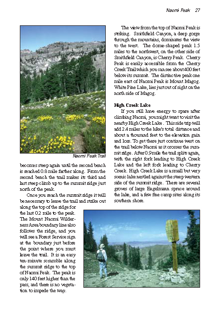
The view from the top of Naomi
Peak is striking. Smithfield Canyon, a deep gorge through the
mountains, dominates the view to the west. The dome-shaped peak
1.5 miles to the northwest, on the other side of Smithfield Canyon,
is Cherry Peak. Cherry Peak is easily accessible from the Cherry
Creek Trail which you can see about 400 feet below its summit.
The distinctive peak one mile east of Naomi Peak is Mount Magog.
White Pine Lake, lies just out of sight on the north side of
Magog.
High Creek Lake
If you still have energy to spare
after climbing Naomi, you might want to visit the nearby High
Creek Lake . This side trip will add 2.4 miles to the hike's
total distance and about a thousand feet to the elevation gain
and loss. To get there just continue west on the trail below
Naomi as it cross the summit ridge. After 0.9 mile the trail
splits again with the right fork leading to High Creek Lake and
the left fork leading to Cherry Creek. High Creek Lake is a small
but very scenic lake nestled against the steep western side of
the summit ridge. There are several groves of large Engelmann
spruce around the lake, and a few fine camp sites along its southern
shore. |