|
Links to other sites:
Ordering books & Maps
Comments about this site or our book:

|
One can hardly visit this
remarkable canyon without wondering about the dozens of other
similar tributaries of Glen Canyon that were flooded by Lake
Powell in 1964. Dark Canyon is more than 200 river miles upstream
from Glen Canyon Dam, and consequently it was spared most of
the destruction of the lower canyons. What were the other canyons
like before they were filled with water? What geological, biological,
and archeological treasures did we loose? And what gems of natural
beauty are now gone forever? A few of the canyons were photographed
and studied before the man-made flood occurred, but many of them
had never been visited by more than a few hundred people before
they were erased from our maps and replaced with jagged blue
lines. We cannot know how much we have lost, but if Dark Canyon
is any clue the loss was substantial.
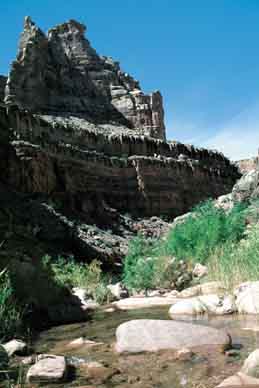
The hike described here touches
only a few miles of Dark Canyon_the section just above Lake Powell.
In my opinion, however, this is the most beautiful part of the
canyon. There is a reliable stream here, and the greenery contrasts
sharply with the pink sandstone and shale in the canyon walls.
Near the bottom of the canyon is a fascinating layer of Honaker
Trail limestone that is chock full of well preserved 300-million-year-old
fossils. Beneath that the picturesque creek flows for several
miles across a layer of smooth limestone, adorned with a series
of idyllic swimming holes and water slides.
Dark Canyon is over thirty miles
long, and there are many other hiking opportunities along its
length. The upper part of the canyon is part of the Manti-La
Sal National Forest, and since 1984 it has been protected as
the Dark Canyon Wilderness Area. The lower part, unfortunately,
is on BLM land and is not within the boundaries of the wilderness
area. Another interesting hike through Dark Canyon begins in
the wilderness area at Woodenshoe Canyon, near Natural Bridges
National Monument, and exits 31 miles later on the Sundance Trail
described here. Unfortunately, however, the two trailheads are
63 miles apart.
Day 1
The Sundance Trail is not really
a trail at all, but rather a well marked route into Dark Canyon.
From the car parking area just walk across the earthen dam below
the cattle tank and look for the first rock cairn on your left.
After you have spotted the first cairn you should have no trouble
following the rest. The trail meanders northward across the slickrock
for about a mile before you begin to notice the presence of a
deep side canyon on your right. It then skirts around the northern
edge of this side canyon, bearing east for another mile until
it reaches the rim of Dark Canyon. It will take you about an
hour to walk from the trailhead to the canyon rim.
The view from the rim of Dark Canyon
is awesome. The canyon is 1,280 feet deep at this point, and
the sensation is not unlike the feeling one gets when looking
into the Grand Canyon: a feeling of grandeur, a feeling of immensity,
and most of all a feeling of personal insignificance. It is also
abundantly clear from this vantage point that the climb down
is going to be a steep one. The canyon bottom is only 1750 horizontal
feet from the rim, and 1280 vertical feet. If the trail had no
switchbacks it would have to descend at an angle of nearly 40
degrees. Of course there are switchbacks, and the route down
is about a mile long. Nevertheless it is a knee breaker, especially
if you are carrying a heavy pack.
After the trail leaves the rim
it drops slightly and then traverses west a short distance to
a place where an ancient landslide has made it possible to get
below the cliffs of the Cedar Mesa Sandstone. It then follows
the rubble slope down, all the way to the bottom of the small
side canyon, and finally emerges from a sandy wash to meet Dark
Canyon Creek.
Once you reach the creek the next
order of business is choosing a suitable campsite. There are
a few nice sites in the area where you first meet the water,
and more sites upstream over the next mile. Beyond the confluence
with Lost Canyon, however, there are fewer campsites. After a
camp is established you will probably want to do some exploring.
As discussed below, there is plenty to see both up and down canyon.
Day 2
Plan on 2 1/2 hours to climb back
up the Sundance Trail and walk to your car. But before you leave
be sure to take some time to look around. Many people spend four
or five days enjoying the quiet beauty of Dark Canyon, but you
should be able to see most of the highlights on a two-day trip.
Side Trips
The Sundance Trail meets Dark Canyon
Creek in a section where three major canyons come together, so
there are many opportunities for exploration in the area. Lean-to
Canyon joins Dark Canyon 0.2 mile downstream from where the trail
ends, and the junction with Lost Canyon is 0.9 mile upstream.
Both of these side canyons are dry; hence few visitors bother
to go very far into them. But if what you are looking for is
solitude they might be just your thing.
The bottom of Dark Canyon above
the confluence with Lost Canyon is particularly interesting.
Here the creek flows over long stretches of hard, blue-gray limestone
which has strange intrusions of chert imbedded in it. Occasionally
another layer of limestone is also exposed just above the intruded
layer that is a treasure-trove of marine fossils. Youngs Canyon,
a beautiful canyon with a stream and a waterfall at its mouth,
is about 6.0 miles upstream from the Sundance Trail. The creek
in the bottom of Dark Canyon ends about a mile above Youngs Canyon,
so if you plan to continue beyond that point you will have to
carry your own water.
The most popular side trip in lower
Dark Canyon is the hike downstream to Lake Powell. The round
trip from the Sundance Trail requires only about 3 hours, but
some minor scrambling is necessary. For the first half hour it
is an easy walk along the bottom of Dark Canyon. Several stream
crossings are necessary, but there are no serious obstacles to
impede the way. After about a half hour, however, you will encounter
a series of pouroffs in the canyon that are increasingly difficult
to get around. When you reach a point where you can no longer
stay in the bottom of the canyon you will have to scramble up
to a ledge about 15 feet above the right (east) side of the streambed.
If you can’t find a way up, just backtrack a ways until
you see an easy way to climb to the ledge.
Once you reach the ledge you will
see a fairly distinct trail that continues downstream above the
creek. This trail continues for the next mile, climbing as high
as 150 feet above the water. Finally you will come to a point
where another large side canyon comes into Dark Canyon from the
east, and it is here that the trail again descends to the canyon
floor. Once the trail gets back to the floor of Dark Canyon just
continue downstream for another 1.1 miles. After a half hour
the stream becomes stagnant and the bottom of the canyon is covered
with a thick, gooey mud that gets deeper and deeper as you proceed.
This is the beginning of the lake. Unless the lake level is low,
the last mile of Dark Canyon will be flooded, making it impossible
to get to Cataract Canyon and the Colorado River without a boat. |