The Venable and Comanche trails together form a popular
loop hike into the Sangre de Cristo Wilderness Area. The route follows
Venable Creek up to the crest of the Sangre de Cristo Range, then traverses
the west side of Spring Mountain. From there it crosses Comanche Pass and
follows the Comanche Trail back to the trailhead. You might also want to
consider bagging two thirteeners along the way. Venable Peak (13,334 ft.) is
just 554 feet above the highest point on this trail, and Comanche Peak
(13,277 ft.) is 577 feet above Comanche Pass. Both peaks are relatively easy
uphill walks from the trail.
With an early start the basic loop trail can be walked in
one day. But if you want a more relaxed outing I suggest you spend one night
either at Comanche Lake or in the basin below the Venable Lakes. There are
no nice campsites near the Venable Lakes themselves.
The path leaves the trailhead in a northerly direction
through a forest of Ponderosa pine, then slowly begins bending around to the
west. After just a few minutes you will come to a trail junction where the
Rainbow Trail branches off to the left, then 0.3 mile later you will arrive
at a second junction where the Goodwin Trail branches off to the right. Five
minutes after leaving the Goodwin Trail junction you will begin to hear
running water on the south side of the trail. This is Venable Creek, which
you will be following all the way to its source.
After the trail meets Venable Creek it begins a long,
unbroken climb up the valley toward the Venable Lakes. The grade is not
particularly steep, but it is unrelenting. After 1.8 miles you will come to
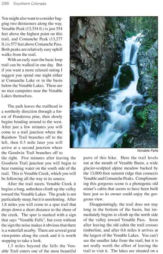
a spur trail that drops down a short distance to the shore of the creek. The
spur is marked with a sign that says "Venable Falls", but even without the
sign the noise makes it obvious that there is a waterfall nearby. There are
several great viewpoints along the creek and it is worth stopping to take a
look.
1.3 miles beyond the falls the Venable Trail enters one
of the most beautiful parts of this hike. Here the trail levels out at the
mouth of Venable Basin, a wide glacier-sculpted alpine meadow backed by the
13,000-foot summit ridge that connects Venable and Comanche Peaks.
Complimenting this gorgeous scene is a photogenic old miner’s cabin that
seems to have been built here just so its owner could enjoy the gorgeous
view.
Disappointingly, the trail does not stay long in the
bottom of the basin, but immediately begins to climb up the north side of
the valley toward Venable Pass. Soon after leaving the old cabin the trail
crosses timberline, and after 0.6 miles it arrives at the largest of the
Venable Lakes. You can’t see the smaller lake from the trail, but it is not
really worth the effort of leaving the trail to visit it. The lakes are
situated on a high, rocky bench, quite removed from the picturesque valley
below, and they are not particularly scenic.
0.4 mile after leaving Venable Lakes the trail comes to
another junction. If you turn right here you will be heading toward Venable
Pass, but in order to complete the loop you must bear left toward Comanche
Pass. The next 0.6 mile of trail is an exciting segment. The path gains
another 340 feet before reaching 12,780 feet, the highest point on this
hike, and crossing to the west side of the ridge. The last few hundred yards
are along a very narrow constructed trail with significant exposure on the
left side. I wouldn’t want to attempt this trail in icy conditions. In warm,
dry weather the danger is minimal, but it is definitely exciting.
As the trail crosses the ridge Venable Peak seems almost
close enough to hit with a rock. If you have the time and inclination to bag
a thirteener it is an easy 20-minute scramble to the top. The summit is 0.3
mile from and 554 feet above the trail.
After crossing the ridge the trail heads south with very
little change in elevation toward Comanche Pass. It reaches the pass after
1.0 mile, crosses to the east side of the ridge, and starts down into
Comanche Lake basin. Again, it is tempting to bag another named thirteener
before starting down. Comanche Peak is just 0.3 mile further up the summit
ridge-an easy 20-minute walk away. The peak is 577 feet above Comanche Pass,
but the terrain is not particularly difficult.
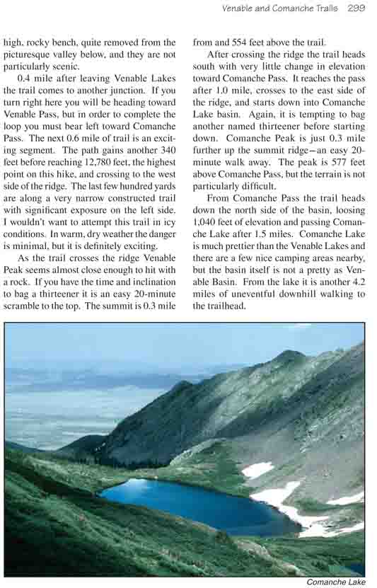
From Comanche Pass the trail heads down the north side of the basin,
loosing 1,040 feet of elevation and passing Comanche Lake after 1.5 miles.
Comanche Lake is much prettier than the Venable Lakes and there are a few
nice camping areas nearby, but the basin itself is not a pretty as Venable
Basin. From the lake it is another 4.2 miles of uneventful downhill walking
to the trailhead.